In 1930, the city of Richmond decided to change the names of a lot of streets. The city decided to rename streets in the northwest and southwest sections of the city to conform to the “Philadelphia System” of street naming that was in use on the east side of the city. This involved street names that were based on numbers and letters. The names of streets in the city prior to this were a mix of many things, as with most cities and towns.
The information for this post came the Richmond Palladium-Item of 14 November 1930. “The placing of 600 street markers throughout the city has been started under direction of the city engineer’s office.”
“It has been pointed out that the erection of these markers is expected to reduce to a minimum misunderstanding which has resulted after a large number of streets in northwest and southwest portions had been renamed to conform with the city’s alphabetical and numeral system.”
Most of the changes were to be done in the Peacock section of the west side, but not in the original West Richmond. Those street names are still the same as they were before 1930.
Street name changes that were made at the time were: Kinsey Street, North West A Street. Pearl Street, North West B Street. Lincoln Street, North West C Street. Randolph Street, North West D Street. Chestnut Street, North West E Street. Laurel Street, North West E Street. Center Street, North West F Street. State Street, North West G Street. John and Williams Street, North West H Street. Sherman and Charles Street, North West I Street. Grant Street and Linden Avenue, North West J Street. Maple Street, North West K Street. School Street, North West L Street. Stevens Street, North West M Street. Charles Avenue, North West Fifteenth Street. George Street, North West Sixteenth Street. Highland Streets, North West Sixteenth Street. West and Cottage Grove Avenues, North West Seventeenth Street. Roscoe Street, North West A Street. Hilda Street, North West C Street.
Catherine Street, South West D Street. Florence Street, South West D Street. Collins Street, South West C Street. John Street, South West A Street. Moorman Street, Southwest Nineteenth Street. Gilbert Avenue, South West Thirteenth Street. Williams Street, South West Fourteenth Street. Charles Street, South West Fifteenth Street. George Street, South West Sixteenth Street. Church Street, South West Seventeenth Street.
North D Street from Doran Bridge to Fort Wayne Avenue (now Middleboro Pike) was changed to Richmond Avenue. I am not sure when it happened, but Richmond Avenue was, at one point, Asylum Avenue on the west side of the Whitewater River.
When I was younger, before I really started getting into becoming a road geek, the only road that I could tell you anything about was Interstate 70. It was the first one that I could remember. This was because I spent, at least in the back seat of the car, a LOT of time on that road. It was the first road that I remember learning things like exit signs and mileage markers. My family is from Pennsylvania. I describe getting to my ancestor’s location as driving on I-70 to the end, and keep going. (The end being New Stanton, PA. I-70 changes into US 119 there.) But, this is an Indiana Transportation History blog, not a history discussion about me.
Interstate 70 has been voted by some YouTubers the greatest of the cross-country interstates. The first newspaper reference that I have found about it came from the Muncie Star Press of 29 November 1957. The Headline read: “‘Interstate 70’ Name of New Highway.” The story went on to state “Federal Interstate Highway 70 is the name officially chosen for the projected New York-to-St. Louis federal super-highway that is to follow a course roughly parallel to U.S. 40. Its marked will be a shield with a red, blue and white background carrying the word Interstate across the top, the word Indiana at the bottom and in the center the figure 70.”
The National Road Traveler of Cambridge City reported, on 27 March 1958, that the Indiana Farm Bureau met with about 150 Henry County farmers to explain the rights of property owners along the new route. “The right-of-way for Interstate 70 will be 300 feet, which amounts to about 30 acres per mile.” The farmers were told that when considering the value of the property, keep in mind everything there – buildings, wells, septic tanks, fences and the cost of the land.
When the decision was being made about where to locate Interstate 70, there were a lot of things in play. Believe it or not, there were financial things taken into consideration. The plan was to put I-70 from 1.75 to 2 miles north of U.S. 40 According to the Tri-County Banner, Knightstown, of 6 February 1958, “highway engineers believe that the corridor between the two highways would be wide enough to constitute valuable industrial and business sites, conveniently located to rail as well as highway facilities.” Yes, you read that right. The location of railroad facilities was considered, at least in Indiana, for the location of the interstate.
Another thing mentioned in this article is that the plan was to try to use section lines as much as possible. Given the information put out, it would put the interstate, according to the newspaper, south of Spiceland. This would be located south of the Central School in the area. But the section line actually ran along the south edge of Spiceland, and through the school itself. That section line is located 2.5 miles north of U.S. 40. “Survey crews are already at work north of Richmond and it has been announced that the proposed highway will be slightly more than 2.6 miles north of U.S. 40 at Centerville, but will then swing slightly southward. The road will leave Wayne county about two miles north of U.S. 40 at Cambridge City.”
The Richmond Palladium-Item of 18 December 1958 reported “Record-Breaking Road Plan Includes Bypass.” The Chairman of the Indiana State Highway Commission was interviewed about the pending project. Chairman John Peters mentioned that the bids for the I-70 project at Richmond would be taken in March 1959. Right-of-way purchasing would also be started in early 1959. He also mentioned that three changes in the routing of the bypass, at the request of residents of both Richmond and Wayne County, have delayed the project for about a year.
This is just a small snippet of what went into creating Interstate 70 across, at least, eastern Indiana. At some point, I will be covering western Indiana. And the other interstates in the state.
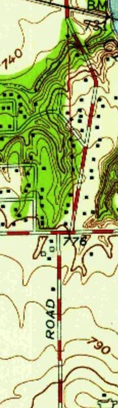
The first part of the new beltway (almost) around Indianapolis started on the westside of Marion County. As mentioned in other articles, the original plan was to start Interstate 465 at Interstate 65 on the northwest side, with the replacement for State Road 100 (which I-465 officially was) heading south from there to circle around the county from there. Interchanges were planned at I-65, I-74/US 136, 10th Street, US 36 (Rockville Road), US 40 (Washington Street), Weir Cook Municipal Airport (Airport Expressway), Interstate 70, and SR 67 (Kentucky Avenue). According to USGS topo maps, like that included below, show that there was a stub ramp connecting I-465 to 62nd Street, although the ramp connecting to 62nd Street was listed as still proposed six years later.
1962 USGS topographic map showing the original interchange connection Interstate 65 and Interstate 465.
Construction started along the corridor in 1959. The Indianapolis News ran a series of pictures showing the plans set out by the State Highway Department. If you noticed the list of interchanges above, there were no plans for 56th Street or 38th Street to have ways to access 465. Bridges were to be built over 465 at 56th, 46th, 38th, 34th, and 21st Streets. (21st Street was a very special, and contentious, situation. I covered it in the article: “Building I-465 at West 21st Street. [8 May 2020]”)
Indianapolis News, 14 December 1959, showing the Indiana State Highway Department’s plans for the new Interstate 465 (also still called State Road 100 at the time) at the northern terminus of the highway.
The plans for Interstate 65 at that point were to continue to have it replace US 52 (Lafayette Road). The US 52 bypass at Lebanon was made part of the new I-65. The temporary plan was to connect I-65 just southeast of I-465 directly to US 52 until construction could continue. Then I-65 would also be US 52 from that point to northwest of Lebanon. I mention this only because the loop around Indianapolis was, apparently, easier to get approved than trying to run I-65 through town. (And since it would take another 16 years to complete, even to the point that an addition was planned to I-465 and completed before I-65 through Marion County says it all.)
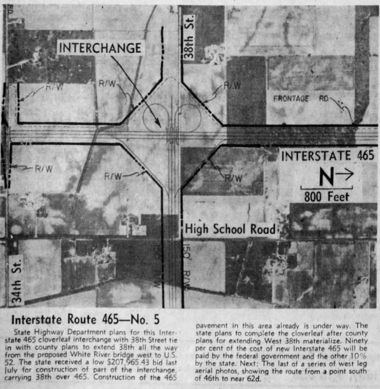
It wouldn’t take long after the original plans for the interstate were laid down that changes were made. The non-planned 38th Street interchange was added to the deal. It was to be a partial cloverleaf interchange connecting to 38th Street at that point. Marion County had decided to build 38th Street from Lafayette Road east to the new White River bridge to be built by the city. At that point in history, 38th Street was a county road with nothing resembling the connections it has today as a major west side thoroughfare.
Indianapolis News, 11 December 1959, showing the future connection to 38th Street from I-465. This ramp would be built much later, when 38th Street was finally connected as a thoroughfare across Marion County.
The next interchange south of the “gonna be built someday” 38th Street was the connection to another interstate highway, Interstate 74. The plans shown in the Indianapolis News differ slightly from what was actually built. US 136 (Crawfordsville Road) is directly connected to the east end of the proposed interstate connection. This would change. It looks like the proposed interchange was moved slightly north, and Crawfordsville Road west of High School Road was turned north to connect to High School Road. This would be where US 136 would ultimately officially end.
Indianapolis News, 10 December 1959, showing the proposed connection between interstates 74 and 465. The original plan, and this was carried out, is that Interstate 74 would “travel over,” ISHD/INDOT term for multiplex, with I-465 from northwest to southeast Marion County.
1953 Topo map showing the intersection of West 10th Street and High School Road.
The next section did change, at least at one interchange, quite a bit. But before I describe that, let’s talk about the placement of I-465 from Vermont Street north to about where 16th Street would be, if it continued to High School/Girls School Road. The new interstate was planned, in that section, to be built directly over High School Road. This is not really a stretch, since High School Road, from Washington Street south to the Airport, was the original State Road 100. And I-465 was, for all intents and purposes, State Road 100 according to ISHD.
I have written a detailed history of SR 100 (SR 100: How did it come to be? [9 March 2019]) and an article about how, at one point, the connection between SR 100 on BOTH sides of Marion County were to have cloverleaf interchanges (“The Cloverleaf Interchanges at US 40 and SR 100” [20 November 2019]). If SR 100 had been completed on the west side, like it was on the north and east sides, I have no doubt that it would have followed High School Road north, probably, ultimately, to 86th Street, which was SR 100 along the northwest side.
The change in interchanges happened at 10th Street. The original plan was for a full cloverleaf interchange at that intersection. This would have pushed the eastbound 10th Street to southbound 465 ramp back closer to Glen Arm Road, where High School Road was rerouted to miss the interchange. What was ultimately built was a jumbled three-quarter cloverleaf with a flyover from westbound 10th to southbound 465.
In the end, High School Road was basically built over by 465 from Vermont to 10th Streets. 10th Street is a survey correction line, so High School actually moves slightly to the east at that point, as shown in the topo map to the left. For more information about survey lines, check out “Survey Lines and County Roads. (29 March 2019)”
Indianapolis News, 9 December 1959, showing the Indiana State Highway Department plans for I-465 from just south of the New York Central railroad tracks to just north of the Baltimore & Ohio Railroad tracks, including what was to originally be full cloverleaf interchanges at 10th Street and Rockville Road.
1953 USGS topo map of the area of Washington Street and High School Road. The area marked “Ben Davis” would be the location of the new cloverleaf interchange between US 40 and I-465.
From the looks of aerial photos in 1959 as shown in the Indianapolis News, the interchange at Washington Street was going to be very destructive. (Keep in mind that as of the writing of this article, MapIndy, my go to source for historic aerial photos of Marion County no longer offers that service. Maps are available, but the aerial photos are gone.) In addition to the shunting of Morris Street (a survey line and historic route of its own accord), most of where the interchange between US 40 and I-465 was basically what had been the town of Ben Davis.
Another thing would have to happen before this interchange would be built. It was determined, and reported, in July 1959 that an improvement of West Washington Street would have to occur before the interstate reached that point. US 40 was to be widened in the area. The work on Washington Street, however, would have to wait until sewer work in the area was completed…probably in 1961. Plans to widen Washington Street from 40 feet to 68 feet wide, with a four foot median and an eight parking lane on each side, were decided upon. Very little of that plan exists today…and if it does, it’s hard to find.
Indianapolis News, 8 December 1959, showing the proposed area of US 40 and Interstate 465.
The last area covered by the Indianapolis News in the series of articles (actually, it was the first since the editor staff decided to post them south to north, even though the interstate was built north to south!) shows the area of I-465 near Weir Cook Municipal Airport. The one change that I can see is what would become Airport Expressway (check out “Indianapolis’ Raymond Street Expressway” [4 February 2020] for the history of what started out as the Bradbury Expressway) was proposed to connect to the airport heading slightly north of due west, just above Southern Avenue. This section of the (now) Sam Jones Expressway is due east-west at the point it connects to Interstate 465. For a history of what is now Indianapolis International Airport, check out “Indianapolis Municipal Airport.” (20 August 2019)
Indianapolis News, 7 December 1959. This newspaper snippet shows the area of proposed I-465 near the (then) Weir Cook Municipal Airport (now Indianapolis International).
That covers the first of the construction of the State Road 100 replacement. I want to share this one last snippet from the Indianapolis News of 19 October 1960. It shows the construction of I-465/I-65/US 52 at 62nd Street…or the original northern end of Interstate 465.
Indianapolis News, 19 October 1960, showing the original northern end of Interstate 465.
What a year. The Indiana Transportation History blog will be taking the day off. But I want to wish you all a safe, fun and happy holiday. I hope that everything goes your way on this holiday. Celebrate how you wish, and how you can given the situation.
Since Christmas falls on a Friday this year, the next blog entry will be posted on 28 December 2020. See you then!
And for some fun, check out last year’s Christmas post: 2019: Merry Christmas To All! It included the covers of my own Christmas cards.
In 1999, the Indiana Department of Transportation decided that it was time to come up with a system that would help better keep track of features along the roads that for which it was responsible. While is would be based, according to INDOT, on the mileage of the road, it was not a milepost system. It was a locator for maintenance items, other than signs, on the state highway system.
RPS 86 on US 40, Marion County, Indiana (Washington Park Cemetery). From Google Maps, snipped 23 December 2020.
There are many parts to the system. The one that most people would have seen, but not really noticed, were the signs that were put up for use with the system. These consisted of small blue signs with a mile number on it, with a smaller sign, if needed, below it with an offset to that mile on it. The signs themselves were barely wider than the post they were on. Very small in relation to most highway signs. Since they are technically only for INDOT use, their size wasn’t a concern. The public wouldn’t notice them, lessening the sign pollution that departments of transportation have been trying to keep under control forever.
RP 88, Offset .88, US 40 bridge of Buck Creek, Cumberland
I really wish I could have had a better snippet for the offset post, but then, the idea was to give the reader the image of what they roughly look like, so the reader would know what to look for.
The RPS manual is very detailed in its information. For instance, the picture to the left is listed as “RP_U_40_Post_86,” meaning “Reference Post, US 40, Post 86.” The one on the right is listed as “CUMBERLAND CORP. LINE BR 4588 O BUCK CREEK,” at least in the 2004 manual.
US 40 is a very prime example of why this system isn’t to be used as a mileage post system. The system was setup prior to the 1 July 1999 decommissioning of US 31, SR 37 and US 40 inside the Interstate 465 loop. What was, in 1999, marked as mile 86 on US 40 is, in 2020, at mile 92.37 on that very same road in 2004. In 2016, the last update from INDOT, it was listed as US 40 mile 65.179. The legal definition of US 40 was lengthened when it was rerouted along the southside of Indianapolis on I-465 in 2004. By a little over six miles. By 2016, the extra mileage along I-465 was removed to show a more accurate road mileage count towards INDOT’s limit of 12,000 miles.
But there is a bit more to the reference post system that comes into play. Each highway listed in the RPS not only includes the complete mileage for the road in Indiana, but they are also listed by the mileage per county, as well. For instance, reference post 86 above is listed as Marion County mile 24.06 in 2004. In the 2016 manual, that mileage is 5.027.
Then, the reference post system records almost everything along the road. This includes EVERY village/town/city street that intersects with the posted road. For instance, near reference post 86 is, in the 2004 manual, “86 + 0.21 24.52 IR 4193 LT (DELBRICK LN).” At reference post location 86.21, 24.52 route miles into Marion County, Delbrick Lane connects to Washington Street (US 40) on the left (north) side of the road. Directions are listed from the increasing number of the reference post. Every street is listed, although almost none of them have a reference post sign.
Also, the corporation limits of towns and cities are listed by the reference post location, although there is no reference post installed most of the time. This even includes old corporation limits. For instance, in the 2016 manual, reference post 85+0.686 is listed as “City or Town Limit – Indianapolis.” Post Road is reference post 86+0.668. Legally, Indianapolis continues for another at least two miles (the sign welcoming one to Indianapolis is west of German Church Road, the county line is another mile east of that, but that is in the town of Cumberland. And even legally, Cumberland is part of Indianapolis. It is as confusing as all get out, but suffice it to say, for the past 50 years, the city limits of Indianapolis have been the county limits of Marion County, with some exceptions. Certainly not Post Road.
But the idea of the legal multiplex of I-465 with almost every INDOT road in Marion County (there are two that don’t mix with I-465: US 136 and SR 135) that brings up another question. What about multiplexes of state roads?
When the system was created in 1999, it was designed with a hierarchy of roads. That hierarchy was interstate, US highway, then state road, in that order. INDOT does not use the term “multiplex” officially. It is called “travel over” in Indiana. The following picture comes from the INDOT RPS guide of 1999 showing how “travel overs” are handled when it comes to marking the mileage of the road.
Indiana Department of Transportation Reference Post System Users Guide, May 1999.
As you can see, near Frankfort, US 421 takes precedence with the little blue signs. SR 39 is junior to SR 38 when it comes to the signs, only due to the fact that 38 is before 39 numerically.
The system underwent some changes between 2004 and 2015. In 2015, it was made perfectly clear that the manual may contain some mistakes, but that every effort was taken to avoid them.
There was also a special note involving US 40 in Vigo County. When US 40 was removed from most of Vigo County, and rerouted along I-70 and SR 46, the RPS system was not changed to reflect that. The section of US 40 that “travels over” SR 46 is still labelled as SR 46. Here is INDOT’s explanation: “US 40 in Vigo County has a special issue that needs to be addressed. Due to relinquishments and creating a travel over for US 40, the alignment does not follow the historic path. US 40 now traverses where SR 46 has traditionally been and SR 46 is considered the Travel Over on US 40. However, the existing reference posts are still for the SR 46 route and are running in a contrary direction to the increasing direction of US 40. Therefore, for the purposes of this book, RP and Offset for the first 3 miles of US are based on the State Log Measure until it reaches the traditional location for US 40 and then jumps to RP 11 + 00 at the intersection of SR 46 and US 40.”
I mentioned above about the original system being put in place prior to the decommissioning of routes in Marion County. It is important to note that there were more routes affected than just those that were moved to I-465. Those routes were US 31, SR 37 and US 40. The mileage on those roads got weird, yes. But there were two others that were affected by the change…and one most people didn’t even realize.
SR 135 was rerouted from Troy Avenue to Thompson Road, cutting two miles out of the official route. This just required moving the little blue signs from north of Thompson Road, and surveying what else would need signs. And what wouldn’t.
The other route affect wasn’t even marked when it was decommissioned. Shadeland Avenue on the east side of Marion County was still legally SR 100 from I-465 to US 40 (Washington Street) until 1 July 1999. For the longest time, the only marker on SR 100 was a smaller blue sign below the reference post signs that read “100.”
INDOT has available on their website the RPS manuals for 2004, 2015 and 2016. Also available is the users guide from 1999. Here are the links for each: Users Guide – 2004 – 2015 – 2016
Today, I want to return to the Auto Trail era. There were many Auto Trails created over the time before the US Highway system took full hold. Even today, the Auto Trail era lives in the names of city streets and county roads. The biggest one that comes to mind is the Lincoln Highway…both of them, actually. But some of the Auto Trails really made you want to ask one question: Why? Today’s road actually made me ask that very question: the Liberty Way.
Since this is an Indiana Transportation History site, I guess that it is good that I can’t find, so far, a map that follows this road outside Indiana. But then it makes me go back to the question above – why? The Liberty Way was an Auto Trail that started in Kokomo, connecting Logansport, Winamac, Bass Lake, North Judson, San Pierre, Kouts, Valparaiso, Hobart, East Chicago, and Whiting to Chicago. Those are the bigger towns along the way. The whole map is available at the Indiana State Library with this 1923 map. The Liberty Way was also shown on the 1920 Rand McNally highway map. Its routing was slightly different.
Basically, I want to do this with maps. Tracing the roads gets a bit complicated in this case. The red line on the maps marked “DD” are the Liberty Way in 1923. On the 1920 map, it is marked “86.”
1920 Liberty Way from Kokomo to Logansport.
1923 Liberty Way from Kokomo to Logansport
1920 Logansport to Winamac
1923 Logansport to Winama
1920 Winamac to Kouts1923 Winamac to Kouts1920 Kouts to Valparaiso
1923 Kouts to Valparaiso
The next two maps are a jumbled mess. Because of Indiana’s location, it has always been the crossroads of America. And these two maps show the importance of Chicago in the grand scheme of things when it came to highways. Indiana’s side of the state line near Chicago was cluttered with way too many road markers.
1920 Valparaiso to Illinois State Line1923 Valparaiso to Illinois State Line
Doing a newspaper search for “Liberty Way” is not the straight forward grasp for information one would hope. Apparently that name was very popular for other places throughout the state. But an ad in the Logansport Pharos-Tribune of 23 July 1921 could tell you, using the Liberty Way, how to get to Bass Lake.
Today, I want to continue the list of streets that were proposed to have name changes during the City Council meeting of 4 March 1912. The list was quite long. And most of them didn’t happen. Or if they did, they are long gone now. This is a follow-up to yesterday’s “1912 Proposed Indianapolis Street Name Changes, Part 1.”
The first one today never was completed, but also didn’t retain the name it had before the proposal. Cooper Avenue between Lafayette Road and the line that separates Wayne and Washington Townships (now 38th Street) was to become Concord Street. At the time, Cooper Avenue did end at Lafayette Road. But a relatively straight line due south would connect to Concord Street just north of 16th Street (between 17th and 18th, actually). By 1926, Concord Street would be completed from Lafayette Road to 16th Street (also still known as Crawfordsville Road by some). It would have a name change as well…but not to Cooper. Concord from 16th to Lafayette, and Cooper from Lafayette to 56th (Centennial Road), would be given the name Kessler Boulevard. It is still called Cooper Road between 56th Street (Centennial Road) and 62nd Street (Isenhour Road).
Before the subject proposal, Brightwood’s Depot Street, from Massachusetts Avenue south to 21st Street, and (what looks like) Laycook Avenue (hard to read on most maps) from 21st south to 19th would be renamed Avondale Place. A street that connected Pratt to 16th Street would be built, and, with Avondale Place, would become Avondale Street. This never happened. Avondale Place still exists, and from what I can tell, what was supposed to be Avondale Street south of 16th Street became known as Kealing Street. Avondale Place south of 21st Street would be removed for industrial development. Avondale Place would be ripped in two by the construction of Interstate 70 in the early to mid 1970’s. (The interstate opened to traffic in 1976.)
The next street name change also never occurred. The new name for the many sections of streets would be Chase. It was to include the first alley west of Bloomington Street from Washington Street to White River, Inwood Street from White River to Michigan Street, Kane Street from Michigan to Walnut Street and Dexter Street from 18th to 22nd Streets. I am not sure about the alley, but I believe it went away when White River Parkway was bent to connect to Washington Street outside the new Indianapolis Zoo. Inwood and Kane Streets are long gone, buried under IUPUI concrete. Dexter Street still exists.
Another large number of segments that would be proposed to become one name was Blake Street. At the time, Blake Street existed from the White River end of Washington Avenue (the original path of the National Road and location of the National Road covered bridge over White River until 1904) north to Pratt Street northeast of Indiana Avenue. Dett Street at Southern Avenue, Brooks Street from 10th to 13th Street, Isabella Street from Myrtis to Udell, Fairview Terrace from Haughey Avenue and 44th Street, and Crown Street from 44th to 45th Street were all included in this change. Dett Street no longer exists…but did at the White River end of Southern Avenue west of Meridian Street. The original Blake Street still exists, in sections. It runs through the IUPUI campus today. Brooks Street still exists. Isabella Street would become Franklin Place. The last two sections are near Butler University. Fairview Place still exists to 43rd Street. Crown Street is between 43rd and 44th Street. I would bet that the street numbers were wrong in the proposal, and that 44th was meant to be 43rd, and 45th was meant to be 44th.
Thomas Street between Brookville Road and English Avenue, Mineral Street from 10th to 19th Streets and Brightwood’s Foundry Street would actually be changed…but not immediately due to this proposal. Those streets would be changed to the name that the street along that line had between Washington Street and 10th Street – Denny Street.
There are still more on the list. As the Indianapolis News mentioned in the last paragraph of the story: “These ordinances are a part of about five hundred contemplated changes in street names. It is Copeland’s plan to give a common name to several streets of different names on the same line. The plan has been approved by postoffice authorities.”
I have been covering Indianapolis street name changes for the past couple of days. It seems that almost every decade along the way had some major changes. I covered a major change with the annexation of the town Irvington and the Tuxedo neighborhood last Friday (Tarkington Street? Not so fast. ITH Blog, 18 December 2020). Today, I want to move into the 1910’s to see what I can find and share.
And it starts in 1912 with a very large proposed change. Most of these never made the maps of Indianapolis in an official way. Councilman Copeland introduced an ordinance that would make a ton of street name changes in the city. These were all submitted to the city council on 4 March 1912.
1905 map of the Arbor Avenue area on the near westside of Indianapolis
The first one involved was was Shover Avenue on the near west side of the city. The recommendation was to turn Shover Avenue into an extension of Arbor Avenue. And it was. From Oliver to Gillette Street, Shover Avenue became Arbor Avenue. But somewhere along the way, the section from the north alley of Oliver Avenue to Henry Street was vacated for the Chevy plant. Arbor Avenue was moved to the east alley Coffey Street, and Division Street was removed completely. Today, Arbor north of Henry exists for a short distance, before being blocked off by a fence and a railroad spur that served the Chevy plant. Also, Division and Gillette Streets are on the private property side of that fence, no longer accessible be the general public.
In addition to Arbor Avenue, an Arbor Street was included in the ordinance along the same line as the Avenue. The new Arbor Street was to include Greeley Street from Washington Street to White River, Limestone Street from Owosso to Michigan, and Porter Street from North to Walnut. The only section of those three streets that still exist is that of Limestone Street, which now connects the end of the New York Street White River bridge to Michigan Street, where it turns into Eskenazi Avenue.
Another one that didn’t quite make it was the renaming of Mobile Street between Senate and Illinois, and Jackson Place, between Illinois and Meridian, to Bates Street. It is on the line of Bates Street east of East Street. No, the name of Jackson Place didn’t go away. It is still called that in front of Union Station.
Poplar Street, between Union and Chestnut Streets, and Bicking Street between Delaware and East Streets to be changed to Bradshaw Street. Not only did this change not happen, the streets in question are now missing from the landscape of Indianapolis. Both fell victim to Eli Lilly and Company.
Bedford Avenue between Raymond and Morris, and King Avenue between Vermont and Tenth Streets to Addison Street. Both King Avenue and Bedford Street are along the same line as Addison Street, but the change was never made.
Mulberry Street between McCarty and Frank Streets, and Union Street between LeGrande Avenue and first alley north of Schiller Street to Pennsylvania Street. I can tell you that at least the southern section, from LeGrande to the alley, did change its name to Pennsylvania. I used to live practically on the corner of both. The name of Chestnut Street would be removed from maps of Indianapolis, becoming an alley between Union and Talbott Streets from Morris to Adler Streets.
Paca Street between Indiana Avenue and Tenth Street was to become Bright Street. This Ransom Place street still maintains its name.
McCormick Place between Muskingum and Illinois Streets to become Anderson Street. This was the name of one of the downtown alleys. The city directory of 1913 states that McCormick is listed under W. Ohio Street.
Smith Lane, between Merrill Street and Stephan Place to Adelaide Street. Adelaide was the name of the alley between New Jersey and East Streets. This change didn’t happen. Today, it wouldn’t matter as Eli Lilly has mowed the entire neighborhood down.
1945 Polk Indianapolis City Directory S
The last one that I want to cover is one that actually did happen, eventually. On 20 June 2019, I covered the “The Indianapolis end of the Brookville (State) Road.” The original end of Brookville Road was at the National Road west of what is now Sherman Drive. The road that winds behind the shopping center at Sherman Drive and Washington Street was originally part of the Brookville Road. By 1900, the section west of Sherman Drive was called Brookville Avenue. In 1912, it was recommended that it be changed to Ewing Street. At some point, S. Brookville Avenue was changed to Brookville Boulevard, and Brookville Avenue east of Sherman Drive reverted to Brookville Road, the name it had originally. Maps and city directories into the 1940’s still show Brookville Avenue/Boulevard. It would be 1945 until the Polk City Directory would list the following entries: Brookville Avenue – Changed to N. Ewing. Brookville Boulevard – Changed to S. Ewing.
When running through newspapers looking for things to write about, some articles just stand out as both a historic fact and a fun story. Thus, today’s story from the Indianapolis News of 19 January 1903. The headline starts with a simple “Tarkington’s Name Too Long For Street.” That was enough to catch my interest. But this story also drips with a kind of irony that makes it worth it.
The lead paragraph, as is taught in Journalism class (I know from experience), gives a good idea of what is going on. “The fame of Booth Tarkington, author-politician, will not be impressed on future generations by having a street in classic Irvington named after him. They will have to remember him by his book and his reputation as a legislator.”
Yes. The idea was to rename a street in the college town of Irvington after the author of “The Magnificent Ambersons,” among others.
The topic of street name changes came up because the town of Irvington had just been annexed by the City of Indianapolis. Another neighborhood, Tuxedo, was also taken into the city around the same time. Tuxedo was located between the old city limits and Irvington. Or more precisely, between Sherman Drive and Emerson Avenue, from Washington Street to 10th Street. This required a large number of street names to be changed to avoid confusion between the two. I will include the list below.
But the subject name, Tarkington Street, is what I want to discuss first. The plan by the City Engineer’s office, was to change the name of Maple Avenue to Tarkington Street. Oh, but then the protest letters started pouring in. Tarkington was too long a name. Those on Maple Avenue wanted a name that was easier to pronounce. That was the argument. So, the city engineer decided to change the name of Maple Avenue to Bolton Avenue.
Another name change that brought the ire of Irvingtonians was that of Downey Avenue. Downey was the name of one of the original founders of the town. He was also the one that came up with the name “Irvington” for the community. The thought that it would be changed to Thompson Avenue did not go over well in the newly annexed town. Another reason involved a church. The “Downey Avenue Church” would have to change its name, as well. As it turned out, the reason they wanted to change the name is to avoid confusion with Downey Avenue in the city. It, however, did not have a sentimental connection to the neighborhood. It was changed to Orange Street.
The street names changed in Irvington and Tuxedo were as follows: Central, Irving and College Avenues, from Brookville Avenue to Lowell Avenue: Audubon Road. Detroit Street, from Huron to English: Mozart Avenue (later changed to Bosart). East Street, from Washington to PRR: Sheridan Avenue. Parkman Avenue, Ivanhoe Street south: Catherwood Avenue. Warren Street, Washington south to PRR: Catherwood Avenue. Orchard Street, Washington south to PRR: Webster Avenue. Parkman Avenue, Oak north to PRR: Webster Avenue. Prescott Avenue, B&O tracks north: Webster Avenue. South Avenue, between the B&O and University Avenue: Good Avenue. Perry Avenue, Julian Ave. to PRR: Berry Avenue. Maple Avenue, PRR to Lowell Avenue: Bolton Avenue. Pleasant Avenue, Lowell to Chambers: Bolton Avenue. Maxwell Avenue, Lowell to Chambers: Hursh Avenue. Green Avenue, Lowell to Chambers: Lesley Avenue. Pleasant Street (first west of Emerson): Bancroft Avenue.
I will just include the newspaper article list of names that were changed in the city to avoid confusion. There were also a collection of streets that were finally given a name in this batch of street name changes.
The name change of Quincy Street to McKim Street ended up being pointless, although still understandable. The Quincy Street that remained would be in the Tuxedo neighborhood, west of Emerson Avenue. Depending on where you are, it is either two west of Emerson (on Washington Street) or three west of Emerson (New York Street north). Later, it would be changed to DeQuincy Street.
I hope that you find this as interesting as I did.
Street name changes in Indianapolis have been a constant thing. Major renamings have occurred several times. But minor changes were made throughout the history of the city. Today, I want to look at some of the minor changes that happened, or would have happened, in the 1930’s. There is no particular reason I chose the 1930’s, other than the fact that was the time period that I was researching for something that didn’t pan out.
In June 2019, I wrote an article called “Why Do Indianapolis Street Numbers Start at 9?” Originally, it was planned that 10th would be the first numbered street. But right before Christmas 1931, the City Council decided that the new lowest street number would be Nine. Pratt Street, a historic name in the city, would be changed to Ninth Street. The street had been named after Julius Pratt, a prominent citizen in the early days of the area. “Somebody conceived the idea that the name was not sufficiently dignified and, naturally, it was not difficult to get an array of signatures on a petition to change it.’ (Indianapolis Star, 23 December 1931, pp 8)
A street extension, mostly by the city, but would be taken over by the state later, called for a street name change. Daisy Avenue, a street that connected Raymond Street just east of the White River to Bluff Road was changed to West Street. This was in preparation for the city to complete West Street from 16th Street to Bluff Road. The ordinance making the street name change was passed by the City Council on 15 October 1934. Eventually, the entire section of West Street mentioned (from Bluff Road to 16th Street) would find itself part of the state highway system. South of Washington Street, it became SR 37, replacing Bluff Avenue (Road) and Meridian Street. (SR 37 ended in downtown Indianapolis at the time.)
In April 1937, a “discussion” between the City of Indianapolis and residents of Irvington were started, and finished, about the changing of street names in the neighborhood. The biggest fear was that Julian Avenue, named after one of the founders of the town, would be changed to Maryland Street in an effort to keep street names consistent through the city. The City Council announced that very few changes would be recommended…and there would be public meetings about them as they were announced.
There was a post in one of the newsgroups on Facebook to which I subscribe. The poster was asking about a relative that lived on Manlove Street. What happened to Manlove Street? May 1939, a series of 11 name changes were urged on the northside. These name changes would be between 42nd and 52nd Streets. The names were to be changed to the names of roughly the same streets north of 59th Street.
These name changes were: Arsenal to Indianola; Sheldon to Rosslyn; Hovey to Primrose; Ralston Avenue to Ralston Drive; Schofield to Buckingham Avenue; Sangster to Norwaldo; Manlove to Crittenden; Baltimore to Evanston; Caroline to Burlington; Hillside to Cambridge and Brouse to Allenby. Not all of these proposed changes were actually done.
There weren’t many. Street name changes are not taken lightly due to all of the things that go along with it: new street signs; address changes with the post office; property records; etc. But I plan to cover more as time goes on.
In May, 2019, I wrote an article about the Milwaukee Road in Indiana. For the last two days, I have been covering the bankruptcy of one of the predecessor roads, the Southern Indiana Railway. Two days ago (Bankruptcy of the Southern Indiana Railway, Part 1), I covered the main line. Yesterday (Bankruptcy of the Southern Indiana Railway, Part 2), I covered the branch lines. A lot of legalese, defining exact locations of what was where. Today I want to focus on the spur lines that were defined in the Notice of Sale.
When compiling the list of railroad property, people don’t realize that it requires a complete detailing of the entire operation. These include spur lines for customers.
A Spur from a point on the main line of The Southern Indiana Railway Company nine-tenths (0.9) miles South of Hulman Street, Terre Haute, Indiana, extending in a Westerly direction One and Eight Tenths (1.8) miles to a Gravel Pit.
A Spur from a point on the main line of The Southern Indiana Railway Company One and One Tenth (1.1) miles North of Coalmont, Indiana, extending in a Westerly direction in Clay and Sullivan Counties, Indiana, to a plant of United States Power Company.
A Spur from a point on the main line of The Southern Indiana Railway Company at Coalmont, Indiana, extending in an Easterly direction Five Tenths (0.5) miles to the Pierson Mine.
Mines around the Coalmont, Indiana, area, 1915.
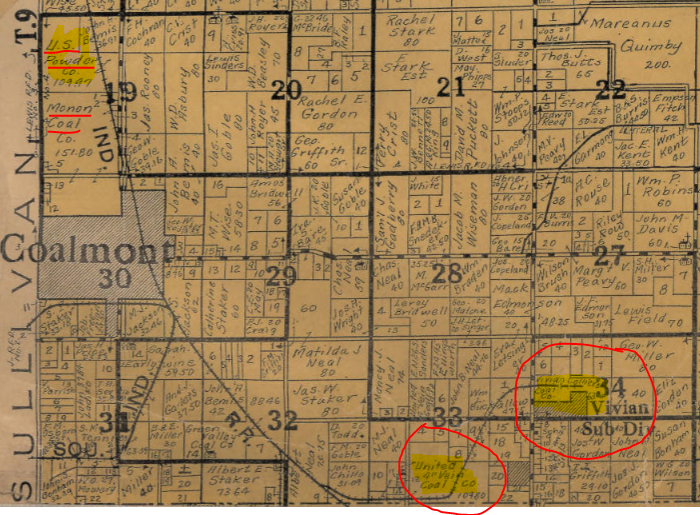
A Spur from a point on the main line of The Southern Indiana Railway Company One and Seven Tenths (1.7) miles South of Coalmont, Indiana, extending in an easterly direction Two (2) miles to the Island Valley and Vivian mines.
Mines in the Jasonville, Indiana, area, 1906.
A Spur from a point on the main line of The Southern Indiana Railway Company in Jasonville, Indiana, extending in an Easterly direction One (1) mile to the Northwest mine.
A Spur from a point in Latta Yard of The Southern Indiana Railway Company extending in a Westerly direction Two and Three Tenths (2.3) miles to the Lattas Creek mine.
A Spur from a point in the Latta Yard of The Southern Indiana Railway extending in a Westerly direction Five Tenths (.5) miles to the Letsinger mine.
A Spur from a point on the main line of The Southern Indiana Railway Company four tenths (0.4) miles North of Midland, Indiana, extending in an Easterly direction One and Six Tenths (1.6) to the Tower Hill mine.
A Spur from a point on the main line of The Southern Indiana Railway Company Two and Seven Tenths (2.7) miles North of Linton, Indiana, extending in a Westerly and Northerly direction Two and Six Tenths (2.6) miles to the Hoosier and Templeton mines.
A Spur from a point on the main line of The Southern Indiana Railway Company Two and Two Tenths (2.2) miles North of Linton extending in a Southwesterly direction Seven Tenths (0.7) miles to the Black Creek Semi Block mine.
A Spur from a point on the main line of The Southern Indiana Railway Company One and One Tenth (1.1) miles North of Linton extending in a Northeasterly direction One and Two Tenths (1.2) miles to the North Linton mine.
A Spur from a point on the main line of The Southern Indiana Railway Company Two and Five Tenths (2.5) miles South of Linton extending in a Westerly direction Six Tenths (0.6) miles to the Island Valley mine.
A Spur from a point on the Latta Branch of The Southern Indiana Railway Company One and One Tenth (1.1) miles Southeasterly from Gilmour, Indiana, extending in a Southerly direction Two and One Tenth (2.1) miles to the Antioch mine.
A Spur from a point on the Sullivan Branch of The Southern Indiana Railway Company Four Tenths (0.4) miles North of Sullivan, Indiana, extending in a Southeasterly direction Nine Tenths (0.9) miles to the Citizen’s mine.
A Spur from a point on the Coalmont Branch of The Southern Indiana Railway Company Fouth Tenths (.0.4) South of Coalmont, Indiana, extending in a Westerly firection One and Two Tenths (1.2) miles to the Freeman mine.
A Spur from a point on the main line of The Southern Indiana Railway Company at Coxton, Indiana, extending in a Northerly direction 3.4 miles to the E. F. Gilberson & Co. stone quarry.
For those that have been following along, this brings me to 1.5 columns of nine of the legal notice in the Indianapolis Star.
In May, 2019, I wrote an article about the Milwaukee Road in Indiana. Yesterday, I started covering the absolute minute detail that comes when a company is for sale after filing for bankruptcy. Today, I want to show, in detail, the descriptions of the branch lines that the Southern Indiana Railway had at the time of the sale. Keep in mind, this legal announcement of sale would lead to the company that would be leased by the Milwaukee Road.
Notice of Sale of the Properties of The Southern Indiana Railway Company, Indianapolis Star, 28 September 1910.
There is a lot of survey jargon in this one. But it spells out in detail the beginning and end of each branch…with a rough idea of how it got between those two points.
Sullivan Branch: Beginning at a point of connection with the main line of The Southern Indiana Railway Company in the Northeast Quarter (N. E. 1/4) of the Southeast Quarter (S. E. 1/4) of Section Sixteen (16), Township Ten (10) North, Range Eight (8) West of the Second Principal Meridian, Vigo County, Indiana, at a point 198 feet from where center line crosses the north line of the Northeast Quarter (N. E. 1/4) of the Southeast Quarter (S. E. 1/4) of said Section Sixteen (16), and extending thence in a general Southerly direction through Vigo and Sullivan Counties to a point 50 feet Easterly from the center line of the Evansville & Terre Haute Railroad and 207 feet south of Washington Street in the City of Sullivan, Indiana.
The town of Blackhawk, Indiana, is located in Section 16, Township 10 North, Range 8 West.
Shelburn Branch: Beginning at a point of connection with the Sullivan Branch of The Southern Indiana Railway Company in the Southwest Quarter (S. W. 1/4) of the Southwest Quarter (S. W. 1/4) of Section Twenty Seven (27), Township Ten (10) North, Range Eight (8) West of the Second Principal Meridian, Vigo County, Indiana, at a point 83 feet south of the north line of the Southwest Quarter (S. W. 1/4) of the Southwest Quarter (S. W. 1/4) of said Section Twenty Seven (27), and extending thence in a general Southerly direction through Vigo and Sullivan Counties to a point of connection with the Sullivan Branch 271 feet Southwesterly from the East line of the Northwest Quarter (N. W. 1/4) of the Northeast Quarter (N. E. 1/4) of Section Twenty Three (23), Township Eight (8), Range Nine (9) West of the Second Principal Meridian.
Section 27, Township 10 North, Range 8 West is located northwest of the town of Lewis, Indiana. The southwest corner of Section 27 is at the corner of All Street and State Road 246, almost due south of Blackhawk.
Latta Branch: Beginning at a point of connection with the main line of The Southern Indiana Railway Company in Green County, Indiana, in the Northeast Quarter (N. E. 1/4) of the Southwest Quarter (S. W. 1/4) of Section Nine (9), Township Eight (8) North, Range Seven (7) West of the Second Principal Meridian, 312 feet North of the south line of the Northeast Quarter (N. E. 1/4) of the Southwest Quarter (S. W. 1/4) of said Section Nine (9), and extending thence in a general Southwesterly direction through Greene County; thence in a general Easterly direction through Sullivan County to a point 556 feet west of the north and south center line of Section Seventeen (17), Township Eight (8) North, Range Eight (8) West of the Second Principal Meridian.
1906 Map of Wright Township, Green County, Indiana. The red square is Section 9, Township 8 North, Range 7 West…or the beginning of the Latta Branch of the Southern Indiana Railway.
Coalmont Branch: Beginning at a point of connection with the main line of The Southern Indiana Railway Company in Clay County, Indiana, in the Northwest Quarter (N. W. 1/4) of the SOutheast Quarter (S. E. 1/4) of Section Thirty (30), Township Nine (9) North, Range Seven (7) West of the Second Principal Meridian, 62 feet Northwesterly from the south line of the Northwest Quarter (N. W. 1/4) of the Southeast Quarter (S. E. 1/4) of said Section Thirty (30), and extending thence in a general Southwesterly direction through Clay County and Sullivan County to a point of connection on the Latta Branch 987 feet Westerly from where the center line of the Latta Branch crosses the east line of said Section Fourteen (14).
1915 map of Coalmont, Clay County, Indiana. The number 30 below the word Coalmont shows that to be the Section 30 listed in the description of the beginning of the Coalmont branch of the Southern Indiana Railway.
St. Bernice Branch: All the right, title and interest acquired, or which may hereafter be acquired, by The Southern Indiana Railway Company, or Myron J. Carpenter as Receiver, in a branch railroad extending from a point on the main line of The Southern Indiana Railway Company at or near St. Bernice, Vermillion County, Indiana, in a general Southeasterly direction for a distance of approximately five and one-half (5 1/2) miles to the mines of the Clinton Coal Company, said branch railroad being at the date of entry of said decrees in curse of construction under authority granted to the said Receiver by order entered May 19th, 1910.
Thus are all the branch lines of the Southern Indiana Railway as of the sale in late 1910. If you read yesterday’s post (Bankruptcy of The Southern Indiana Railway, Part 1), or saw the first image in this entry, you can see that it is a very detailed legal notice. To the point that this, the second part, only got to the bottom of the first column of the notice. The complete notice takes nine columns…none full page columns. Again, this shows the level of detail any land transaction in Indiana entails…and even more so with something like a railroad that covers a long distance.
This post is going to include a LOT of legal jargon. But, I think it is important to show how the legal definitions of railroad right of ways are documented. It really isn’t “let’s build this this way, damn the consequences.” Well, not entirely.
In May, 2019, I wrote an article about the Milwaukee Road in Indiana. One of the roads that made up what would become part of that western railroad that wandered east was the Southern Indiana Railway. The creation of the railroad will be covered at some point. But while looking at a map of Clay County, there was a proposed Southern Indiana Railroad that went across Clay County that went through Saline City and north of Bowling Green. So I tried looking it up. But all I found was the one connected to what would become the Milwaukee Road.
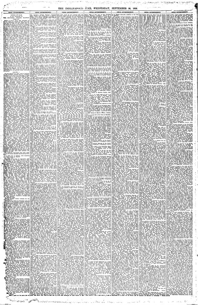
But the topic of this post is the bankruptcy of the Southern Indiana Railway. It made the newspaper legal notices in September, 1910. And it took a complete page and a half in the Indianapolis Star. Yes, a page and a half. I have included the first page below. Do I expect people to be able to read. Oh, no. But to give you an idea of the complete railroad property bankruptcy, this picture sums it up.
Indianapolis Star, 28 September 1910. This is the first page of the “Notice of Sale of the Properies of The Southern Indiana Railway Company.”
The entire property of the railroad is so detailed in this legal notice that it will take a few blog entries to cover the entire thing.
The Southern Indiana Railway filed for bankruptcy in the Circuit Court of the United States for the District of Indiana on 27 May 1910. There were several plaintiffs in the complaint. First was the First Trust and Savings Bank, as trustee. The second was the Girard Trust Company under a deed dated 1 February 1901. Another plaintiff was Alfred M. Chapman. The offices of the railroad were located on Hulman Street, between 14th and 14 and 1/2 Streets, in Terre Haute.
The first parcel listed in the sale of the railroad was described as “all and sigular the main track of railway of the Southern Indiana Railway Company existing at the date of the mortgage or deed of trust made by the Southern Indiana Railway Company to the First Trust and Savings Bank of Chicago, dated May 1, 1906.” This trackage was listed as “commencing at the extreme northwesterly limit of said line as then constructed in Vermillion County, Indiana, at or near the line between the States of Illinois and Indiana, at or near Quaker Hill in the State of Illinois, thence in a southeasterly direction to and into and around the city of Terre Haute in Vigo County, Indiana, and thence in a southeasterly direction in and through the counties of Vigo, Sullivan, Clay, Green, Daviess, Martin, Lawrence, Jackson, Bartholomew and Decatur to the town of Westport in the last name county.”
This description would also include “all its branches diverging from said main lines at or near Black Hawk, Coalmont, and Latta in the State of Indiana and extending to or near Sullivan in said State, said branches being otherwise known as the Sullivan Branch (which includes the Hymera Branch), the Shelburn Branch, the Coalmont Branch and the Latta Branch, and also all other railroad tracks, extensions and branches which said The Southern Indiana Railway Company owned on May 1, 1906, or at any time thereafter constructed.”
Also included in this were “all buildings, lands and interests therein, rights of way and property of every kind on May 1, 1906, owned by The Southern Indiana Railway Company or at any time thereafter acquired.” There is one exception, which goes to show the original planned extent of the railroad. It is listed as “except the lands which it then owned in Wayne County, Indiana.” The original plan for the railroad was to reach to Richmond, in Wayne County. The Southern Indiana ended, at the time, at the Big Four Railway south of Greensburg. That is quite a distance from Wayne County.
1893 Map of Wayne County showing the proposed route of the Evansville & Richmond Railroad through Washington, Centre and Wayne Townships. This route would connect Centerville and Richmond south of the Panhandle Route (PRR).
The main line of the railroad was described in the following legal manner: “Beginning at a point of connection with the railroad of The Chicago Southern Railway on the state line between the states of Illinois and Indiana in the Southwest quarter (S. W. 1/4) of the Section Seven (7), Township Sixteen (16) North, Range Ten (10) West of the Second Principal Meridian.” Legally, most of the state of Indiana is surveyed from the Second Principal Meridian, also called the Paoli Meridian. (The First Principal Meridian forms the line between Ohio and Indiana.)
From there, “and extending thence in a general Southerly direction in and through said county of Vermillion, thence in a general Southerly direction through Vigo County, also from a point in the center line of the right of way of The Southern Indiana Railway Company 33 feet Northeasterly from where said center line crosses the south line of Section 3 (3), Township Eleven (11) North, Range Nine (9) West of the Second Principal Meridian and extending thence in a general Northerly direction to Wabash Avenue in the City of Terre Haute, Indiana, thence in a general Southerly direction through Sullivan County, Clay County, and Greene County; thence in a general Southeasterly direction through Daviess County; thence in a general Easterly direction through Martin County, Lawrence County, and Jackson County and into and through a part of Bartholomew County; thence in a general Northeasterly direction through part of Bartholomew County and a part of Decatur County to a point of connection with the Cleveland, Cincinnati, Chicago and St. Louis Railway.”
To give you an idea of how much information is in the above listed article, I have only covered the first half of the first column in this entry. I will be covering more in entries to come. I know these can be a bit boring, but it is also important to transportation history. Not many railroads in Indiana did not go through a bankruptcy. These types of legal announcements would have been made for each and every one of them, if they were required to publicly announce them. Just looking at one of them sheds a light on all of those things that most people don’t see when it comes to the railroads.
One of the Auto Trails that I have been unable to find much historical information on, yet have seen on many maps, is the Hub Highway. In Indiana, the highway started in Lafayette, working itself across the state to Union City. Along the way, it travelled through Frankfort, Tipton, Muncie, and Winchester on its way to Chillicothe, Ohio.
In Lafayette, it share the Jackson Highway route heading to the southeast. The closest thing to the official start of the road that I can find is Second and Main Streets in downtown Lafayette. This also would be the end of the old Indianapolis-Lafayette State Road. From there, it followed Main Street and State Road 38 out of town, and to Mulberry. At Mulberry, the Jackson Highway, which has been sharing the route with the Hub, split into two. The Hub shared the northern Jackson Highway route, which turned southeast along what is now Gas Line Road. It turned east on what is now Farmers Gravel Road, entering Frankfort on what is now US 421.
The original route of the Hub Highway basically followed what is now SR 28 across Clinton and Tipton Counties to Tipton County Road 300 West. It then turned north on CR 300 W, then east on Tipton’s Jefferson Street. The old route again joins SR 28 until it reached what is now SR 19. It turned north along SR 19 for one half mile to Tipton County Road 100S. East along CR 100S to Tipton County Road 300 East, or State Road 213.
The route turned south along SR 213, crossing SR 28 again and the old Nickel Plate to Tipton County Road 150 South, or old SR 28. The route turned east, crossed the old Nickel Plate again to enter Hobbs. SR 28 becomes the original route of the Hub into Elwood. The Hub then turned south on what is now SR 13 for one mile, to Madison County Road 1100 North. The old highway followed 1100 North, Bethel Avenue, Madison County Road 925 West, and again Bethel Avenue almost all the way to Muncie. At Wheeling Avenue, the Hub turned southeast to enter downtown Muncie.
In Muncie, as best as I can tell, the Hub Highway followed Wheeling Avenue and High Street to Jackson Street. Keep in mind, if you are using this as a travel log, Jackson Street is one way east at this point. Basically, from Muncie to Winchester, the Hub Highway and State Road 32 are one and the same. To get to Union City, the route, as best as can be found, turned north on Union Street in Winchester, and followed that and Union City Pike into Union City.
I am not sure what this highway was supposed to accomplish. But, it seems it would be a great day trip/road trip for those that want to drive a 1917 Auto Trail.
In the early 1910’s, the City of Indianapolis and the several railroad companies that entered downtown came to an agreement to elevate the tracks connecting to Union Station. But, technically, it was one railroad that was responsible for dealing with doing the work. The tracks leading to the Union Station all belonged to the Indianapolis Union Railway (IU).
The original contracts that were let for the work, as reported in the Indianapolis Star of 28 January 1913, also included a determined elevation level for the tracks and the grade to be put in place.
The story in the Star reported that there were problems in the City Council about the contract, and delays involved with it. The Law Subcommittee, consisting of R. W. McBride, Caleb S. Denny, Ralph Bamberger, Reginald H. Sullivan and Frank E. Gavin, “reported adversely on the contract.” The main concern was that the city would be on the hook for helping to pay for “increasing the facilities of the railroads.” The Council announced that they want to talk to lawyers about this situation.
Now to the specifics of what is to be done. Article Two of the contract laid out grades and elevation levels of the tracks through downtown. The tracks were to be elevated to the level of the railroad bridges over the White River, rising at a grade of 4/10 of a foot per 100 feet eastward to Illinois Street. From Illinois to Pennsylvania Streets, the tracks were to be level. After Pennsylvania Street, the downgrade would be .256 feet per 100 feet to Virginia Avenue. It would go back up .335 feet per 100 feet until the center of Washington Street. The Panhandle (PRR) and Cincinnati, Hamilton & Dayton (B&O) tracks were to descend .7 feet per 100 from East Street to Noble Street (College Avenue). The grade of the wye to connect the Madison line, also part of the Panhandle at that point, would ascend at a rate of .76 feet per 100 from Meridian Street to South Street. From Delaware Street to South Street, the wye would ascend .88 feet per 100.
The street clearances were also laid out in Article two of the contract. The following is what was decided, from the newspaper itself:
Indianapolis Star, 28 June 1913, Elevations for Indianapolis Union Railway tracks through downtown Indianapolis.
Of all the streets that would be affected by the elevation, only one was to be removed from the map of the city of Indianapolis. That street was then called Liberty Avenue. Today, it is called Park Avenue.
What caused part of the problem with the City Council is the idea that the ordinance basically ordering the railroad to perform this work (passed in 1905) stated that the city and county would contribute to the elevation of the tracks. But the city refused to pay for any expansion of railroad facilities during this time. Any expansion of the yard facilities that would occur while the elevation was taking place would be borne by the railroad.
The cost was broken up in the contract as follows: Indianapolis Union Railway pays 75%; the remaining 25% would be shared by the City of Indianapolis, the County of Marion, the Town of Woodruff Place and the Indianapolis Street Railway Company/Indianapolis Traction and Terminal Company (both at this point are owned by the Terre Haute, Indianapolis & Eastern Traction Company).
“It is provided, however, that the railway company alone shall bear the cost of laying the tracks after the elevation is completed.”
The history of the track elevation in Indianapolis was covered in the Indiana Transportation History entry of 7 October 2019 called “Indianapolis Track Elevation.”
While doing the article that will appear tomorrow, the newspaper I was looking at had car and tire ads. What stood out to me were the locations of the sales. Also, the prices on those things at the time. This would be 28 June 1913.
Tire ad from the Indianapolis Star of 28 June 1913.
Indianapolis Star, 28 June 1913, used car sales ad.
The following one is what really caught my attention. It looked like a plea to return a car. But no. It was an ad for a car. The location also grabbed my eye: 20 West Wabash Street. For those unfamiliar, that is the alley just north of the Circle, and just south of Ohio Street.
The last things I want to share are personal sales ads that were included in that newspaper.
I know this isn’t normal fare for my blog. But this is transportation history, of a sort. I thought it was interesting. I hope you do, too!
Since it was built, the National Road has held an important place in the history of Marion County. Obviously, the city itself benefitted from the coming of the road. The road was built from east to west, which means when it reached Marion County, Warren Township would be first in line.
1889 map of Cumberland, Indiana
Cumberland. The town was laid out shortly after the coming of the road. The name of the town came from the other name for the National Road. Or, more to the point, the terminus of the road – Cumberland, Maryland. The town was laid out by Henry Brady on 7 July 1831. The original plat only included four blocks, bounded by what was called North, South, East and West Streets (now Niles Street, Saturn Street, Muessing Street and one that no longer exists).
The railroad would come to Cumberland in 1853. The Indiana Central Railway built 71.94 miles of track that year, connecting Indianapolis to the Ohio state line east of Richmond.
The next things that were encountered on the way west were a church and a toll gate one mile west of the county line. The church, built in 1855, was St. John’s Church, but the corner stone is written in the language of the congregation – German. The road would be named later German Church Road. The toll house was opposite the church, on the southwest corner of German Church and Washington.
At the corner of the National and Franklin Roads, a country schoolhouse was located on the southwest corner.
1889 map of Irvington, Indiana
Irvington. Before entering Center Township at what is now Emerson Avenue, the town of Irvington in encountered. Incorporated in March 1873, it was designed as a town of “refinement and culture.” That same year, the Northwestern Christian University was enticed to move to the new town with a 25 acre land donation and a grant of $150,000. The university was tucked between the two railroads that ran through the area, and along the western edge of the town.
If there is one thing that Indianapolis is known for, it is fast cars running around in circles in May. And the transportation history of the Indianapolis Motor Speedway can not be denied. The 2.5 mile rectangle in a farm field five miles northwest of downtown was built to test cars in the early days. The four men that created the Indianapolis Motor Speedway Company were car people. Carl Fisher and James Allison owned Prest-O-Lite, a maker of headlights and batteries for cars. Frank Wheeler made carburetors. Arthur Newby owned the National Motor Vehicle Company.
I want to go into a little more history before getting into the pre-coverage of what would, decades later, become the “Greatest Spectacle In Racing.” Carl Fisher wanted to create a place to test automobiles. Local roads were not of sufficient quality, and the new one mile oval track at the Indiana State Fairgrounds was not good enough either. Fisher’s first plan was to create a five mile track at French Lick. (For those of you that have read my article on the routing of the Dixie Highway through Indiana – “Winners and Losers, Routing the Dixie Highway Through Indiana” – know the irony in that plan.) That plan, obviously, did not happen. And so, in 1909, the Indianapolis Motor Speedway was born.
We look at the speedway today, and we look at the three (max) races held there every year. In 1910, there were MANY races held at the track. As many as 42 in one three-day weekend. This led to poor attendance, and a plan to have one great big race with a lot of money to the winner. This created the first of what would become the Indianapolis 500.
That “extravaganza” was publicized well. The Indianapolis Star of 28 May 1991, had “a history of the careers of the drivers who will pilot the cars in the 500-mile race at the Speedway Tuesday.” I want to focus on their exploits at the Indianapolis Motor Speedway.
The first one mentioned was Ralph De Palma. He started racing on his own in April 1908, even with broken tendons in his arms after a wreck as a mechanicman. In August 1909, he scored four second place finishes with a Fiat stock car. He also won time trials in August 1910 with a 200 horse power Fiat. He also won a ten-mile free-for-all.
The next mentioned was Charles Merz. His first racing experience included crashing through a fence, demolishing his car and narrowly escaping death. That was 4 November 1905. At a race. In Indianapolis. The car company that supplied his racing vehicles was the above mentioned National Motor Vehicle Company. His experience at the Motor Speedway included races in August 1909, May 1910 and September 1910. In these, he either placed first of second. Including running 100 miles “without a stop.”
Robert Burman drove for Benz. His history included driving the very first car built by the Buick Motor Company. He raced several Buick entries across the country. His first experience at the Indianapolis Motor Speedway included several wins in long races in July 1910. But his cars were disqualified, meaning so were his wins.
Indianapolis Star, 28 May 1911
“Happy” Johnny Aitken of Indianapolis. He also drove National Motor Vehicles. His list of accomplishments at the Indianapolis Motor Speedway is rather long. To the point that his list from 1909 is included to the left. Another list of his exploits is included below that. This doesn’t include his running at the December 1909 sessions at the Speedway.
Today, I want to give a brief overview of the next five original state roads that were created with the law that created the Indiana State Highway Commission in 1919. I have covered the first ten, if you are interested, in these articles: “Dec 1917: Main Market Roads Officially Announced” and “Original State Roads 6-10.”
Original State Road #11: This road started in Greenfield, traveling north through Pendleton, Anderson, Alexandria, Marion, Mt. Etna, Huntington, and Roanoke ending at Fort Wayne. Most of the road in Grant, Huntington and Allen Counties was originally built as part of the Fort Wayne State Road, connecting the county seat of Allen County to Indianapolis. From Greenfield to Huntington, it would later be designated SR 9. The original US 24 used the rest of the original State Road 11.
Original State Road #12: This was the designation given to the original Indianapolis-Vincennes State road built in the 1830’s from Bruceville to (almost) Martinsville. It actually ended on the west bank of the White River opposite Martinsville. The southern end of the road was at original State Road 10 at Bruceville. In 1923, the state added the rest of the route from Martinsville to Indianapolis to the designated SR 12. That was discussed in the article “Original SR 22 – The “Fight” For the Way to Martinsville.” With the Great Renumbering, OSR 12 became part of State Road 67. (There is a reason for this road given the number 67…and I covered it in the article “SR 67 – Why?“)
Original State Road #13: Starting at Lewisville, on the National Road/OSR 3, heading north through New Castle, Muncie, Hartford City, Montpelier, Bluffton, and Ossian, to end with OSR 11 at Fort Wayne. The Great Renumbering changed this road to SR 3. Later, the northern section from east of Montpelier would be changed to SR 1 later.
Original State Road #14: This road started at Cannelton on the Ohio River, then north through Tell City and English, ending at Paoli. This road was marked on maps as going in a (as) straight (as possible in southern Indiana) line between English and Tell City. This road would become the new SR 37, sort of. The route would be changed along the way, especially from English to Tell City.
Original State Road #15: Starting at Logansport, the road travelled through Royal Center, Winamac, Knox, and Laporte to end at Michigan City. At the northern end, this road was part of the Michigan Road, but only a short section of it. (Basically the section from what is now the intersection of US 35 and US 20, following E. Michigan Boulevard into Michigan City.) As such, for all intents and purposes, it became a “Michigan Road” shortcut, connecting Logansport to Michigan City more directly. When the Great Renumbering happened, it was numbered as such…SR 29, the same number the ISHC gave to the Michigan Road from Logansport to Madison.