Marion County Road Names, 1905, Part 1

One of my favorite things to do, if you haven’t guessed, is to look at old maps. One of my interests, especially, is to look at names that are printed on those maps, especially for roads. Seeing how long those road names have been on maps is interesting to me. Since I live in Marion County, and that county has the most available maps online, I spend a lot of time at looking at those. And the road names are very interesting. I want to share some of them today.

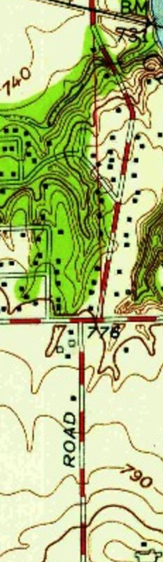
The map that I am looking at as I write this comes from 1905. One of the things with this map is that most of the names are on free gravel roads, roads that were, at one point, probably tolls roads. Not completely sure, but it makes sense in the scheme of things.

The first road that I want to mention was called the Fall Creek and Mud Creek Free Gravel Road. The road itself started in Millersville, at the end of the Millersville Free Gravel Road (now Millersville Road). Millersville, on the maps, is located one quarter mile west of the Washington-Lawrence Township line (which runs along what is now Emerson, or the same line, to 62nd Street) on 56th Street. As one can guess, the road name still exists, kind of. Now it is actually in two parts: Fall Creek Road and Mud Creek Road. The road itself ended at the Hamilton-Marion County line (now 96th Street).

Another road name that still exists on this map is the Hague Free Gravel Road. Yes, it is Hague Road today. But there were three extensions to the road that have different names today. First was a mile long, branching from the main road less than one half mile north of the start of the road at the Fall Creek and Mud Creek Road. That extension went west from the main road. Today, that extension is now called 71st Street.

The second extension from the Hague Road branched west, for three-quarters of a mile, one and a half miles north of the first extension. This connected the Hague Road to the town of Castleton. Today, it is called 82nd Street. The third extension, one and a half miles north of the second, branched east for one mile. It is now part of 96th Street.

Back to the second extension, at the end of the Hague Road extension, it connected to the middle of the Andy Smith Free Gravel Road. That road started at Allisonville Road, traveling east along what is now 82nd Street to where what is now Masters Road used to connect to 82nd Street. Here, it traveled north for one half mile, where it turned east for about two miles along what is now 86th Street.

For what is now Pendleton Pike from 30th Street to Oaklandon Road (and its junction with the Bee Line Railroad), had two different names. From 30th Street to Franklin Road, it was the Indianapolis and Lanesville Road. From that point to Oaklandon Road, and north on Oaklandon Road to the Bee Line tracks, it was the Indianapolis and Oakland Road. From here, an extension of the Indianapolis and Oakland Road followed alongside the railroad tracks to the county line. Both of the mentioned roads were also part of a longer former state road, which by 1905 was called the Pendleton Free Pike.

At the Bee Line tracks, heading north, along what is now Oaklandon Road, was the Germantown and Oaklandon Road. This free gravel road stopped one mile south of Germantown, which was located along Fall Creek at the county line (96th Street today). This road ended at 86th Street. From this point, county dirt roads were the way to get to Germantown, which is now submerged in Geist Reservoir.

What is now 46th Street east of the Indianapolis and Oakland Road, for about two miles, was called, at the time, the Asbury Free Gravel Road. This ended at a point half way between Mitthoefer and German Church Roads. From that point, the one half mile to German Church Road was officially an extension to the Asbury Road.

One half mile south of the Asbury Road was the Henry Bell Free Gravel Road. Technically, this road started at the Pendleton Pike, travelled south on Franklin Road to 42nd Street, and ended half way between Mitthoefer and German Church Roads, like the Asbury Road. Unlike the Asbury Road, the extension was on the west end of this path, connecting the Pendleton Pike to Franklin Road along 42nd Street.

Another road name that hasn’t really changed since the 1905 map is Mitthoefer Road. Now, having said that, there is some question as to the spelling of that road’s name, as the family, as I understand it, spelled it “Mithoefer.” I have seen street signs posted by the city of Indianapolis with both two “t”s and two “f”s, as in Mitthoeffer. Today, the city spells it with one “f” (most of the time). This road started at the National Road, running north to the line separating Lawrence and Warren townships (now 38th Street).

One of the most confusing roads, with many names, is now called German Church Road. First, let’s start with its most common name before it was changed by the county to match the interurban stop name along the National Road. From 30th Street south to the National Road, it was called the Franke Free Gravel Road. However, the other name was also commonly used – Holzhausen Road. To make matters worse, the Holzhausen Road had four extensions. One ran east from the end of the main road one mile to the county line along 30th Street. The second ran north from 30th Street to the Peoria & Eastern/New Castle Traction tracks (anyone familiar with the area, that right-of-way, since both the railroad and the interurban are long gone, it is along the north edge of the Hindu Temple of Central Indiana property). The third extension ran west along 30th Street for one quarter mile. The fourth extension ran one quarter mile west from the end of the third extension.

What is now Muessing Road, connecting the Brookville Road to the National Road, was once part of two different free gravel roads. And it gets a bit confusing, to say the least. For starters, the Cumberland Free Gravel Road left that town just like Muessing Road does today, angled to the southwest. From there, just like today, it followed a very curvy path to what is now Prospect Street. Here the Cumberland Road turned east, then south again almost immediately. The Cumberland Road didn’t go far from there. South of Prospect Street, the road makes a sharp turn to the west. Then, before the road turned south again along the half section line, the Cumberland Road abruptly ended. But, the Muessing Extension started at that exact point, running south along the half section line to the Brookville Road.

The last road I am going to cover today, as this will probably be a long series of articles, is the Bade Free Gravel Road. Now, looking at a map of southeastern Warren Township, there is a Bade Road on it. That current road was part of the original Bade Free Gravel Road. For a mile (technically, about a few feet short of one, but who’s counting?), from the Brookville Road to what is now Prospect Street was the beginning of the Bade Road. It retains that name today. However, the Bade Free Gravel Road turned east for three-quarter mile, then turned north for nearly a mile and a half to connect to the National Road. The east turn is now Prospect Street. The last 1.5 miles is now German Church Road.

There are a lot more roads to be listed. I am not sure how many parts this will be…but I don’t want to make them way too long.

Advertisement

Railroads of Indiana, 1850

One of the beautiful things of the internet, one of the things that make doing something like the Indiana Transportation History blog so easy, is the access to a world of information. Yes, some is accurate, and some isn’t. But my favorite resources, as I have shown over the past almost two years, is maps. While maps can be wrong at times, or more to the point, based on “future” information that doesn’t come to be, they are still a great resource if you can figure where they went wrong.

Today, I found another map that grabbed my interest. Looking at a map of railroads in Indiana, even today, there are railroads all over the state. A railroad map from the turn of the 20th Century is a spider web of routes crossing the state in all kinds of directions. But the map that I found today is one of Indiana in 1850. It is an interesting look what was, and how many changes have come about in the 170 years since it was printed.

When railroads started being built in the state, just like everywhere else, it was a jumble of little companies, usually with destination cities in the company title. There were 15 railroads on the map at the time, with some that were proposed. One of them was in Ohio, but would later be part of an Indiana system when it was completed. The map that I found showed the railroad routes as straight lines, not the actual routes themselves. I am going to cover them in the order the map numbered them.

Number 1: Madison and Indianapolis Railroad. I have covered this railroad many times, as it was the first long distance railroad built in Indiana. The engineering of this route, which included the steepest railroad tracks in the nation, was top notch at the time. Although it was originally been on the cheap, using iron strapped rails instead of the “T” rail that would become standard (and much safer) later. In the end, it would become part of the Pennsylvania Railroad.

Number 2: Shelbyville Lateral Branch. This line was built as a feeder road to the Madison & Indianapolis. Its history isn’t terribly long. It connected the Madison & Indianapolis at Edinburgh to Shelbyville, opening up farm produce from Shelby County to the world at large. The railroad, depending on what history you read because it is very spotty, would last around five years before it was abandoned.

Number 3: Shelbyville & Rushville Railroad. Shelbyville was a “rail center” for a little while in the 1850’s and 1860’s. This route connected the two title towns, opening Rush County to the markets available on the Madison & Indianapolis.

Number 4: Shelbyville & Knightstown Railroad. Another short lived railroad, that would open southern Henry County to the same markets served by the above three. This company would last less than a decade, according to the source. Again, the history is spotty about this road at best. Later, part of route would become part of a railroad again, but instead of connecting Knightstown to Shelbyville, it would connect to Rushville.

Number 5: Columbus, Nashville & Bloomington. Trying to find any history on this road is difficult at best. I am not even sure if it existed at all. This will require more research.

Number 6: Martinsville Branch Railroad. Another road, like the one above. History is hard to find like the one above. It connected the Madison & Indianapolis to Martinsville. Later, the same connection would be made, in 1853, from the M&I at Franklin to Martinsville. That railroad would would be the Fairland, Franklin & Martinsville.

Number 7: Indianapolis & Bellefontaine Railroad. This route connected Indianapolis to Pendleton, Anderson, Muncie and Winchester to ultimately Bellefontaine, Ohio. Down the road, this would be one of the founding parts of the Big Four Railroad. It is still in use today as part of CSX.

Number 8: Indianapolis & Peru Railroad. Today, this is mostly known as the Nickel Plate connecting Indianapolis, Noblesville, Tipton, Kokomo and Peru. Or at least what’s left of it. At one point, for about nine months, it was consolidated with the Madison & Indianapolis creating a route from Madison to Peru under one umbrella. Shareholders, and the courts, put an end to that marriage, creating two separate companies again.

Number 9: Indianapolis & Lafayette Railroad. Another constituent part of what would become the Big Four Railroad. At one point, at the Indianapolis end, the line came down alongside the Central Canal. It would be also be the scene of a large train wreck that would kill members of the Purdue University football team (Part 1 and Part 2).

Number 10: Lafayette & Crawfordsville Railroad. This railroad would later become part of the Chicago, Indianapolis & Louisville, later known as the Monon. At the end of this article, I will show the only proposed railroad that in included on this map, which would be a connecting route from Crawfordsville to Bedford, thus creating the remaining part of the Monon mainline through western Indiana.

Number 11: Terre Haute, Indianapolis & Richmond Railroad. The original plan for this railroad was to connect the entire state, east to west, following roughly the National Road corridor. It would never be built past Indianapolis. Over the years, it would become part of the Pennsylvania Railroad.

Number 12: New Albany & Salem Railroad. This would be the southern end of what would become the Monon. There were several companies between the New Albany & Salem and the Monon. I covered the history of the Monon in two parts, part 1 and part 2.

Number 13: Jeffersonville & Columbus Railroad. Most references to this road refer to it as the Jeffersonville, or “J.” The plan was to build the line all the way to Indianapolis. The problem came with the management of the Madison & Indianapolis. As the first railroad, the M&I assumed the attitude that they were the kings of the state’s railroads and others, especially direct competitors like the “J,” should just be good little kids and do what they are told.

There is a story about the M&I not wanting to help another railroad, because they weren’t in business to provide charity to other companies. The company they turned down would be the THI&R, which would be far more successful than the M&I in the end.

The M&I refused to cooperate with the J. So, ultimately, the J not only invested in feeder lines, taking traffic from the M&I, they started building a parallel track to the M&I. Ultimately, the J would end up buying the struggling M&I. And, like the M&I, would become part of the Pennsylvania system.

Number 14: Lawrenceburg & Greensburg Railroad. This road was built to connect the markets of Decatur and Ripley Counties to the markets at Cincinnati. Ultimately, the plan was to build the road all the way to Indianapolis, allowing a more direct route from the Hoosier capital to the Queen City of the Ohio. Traffic would be barged from Lawrenceburg to Cincinnati, which was faster than the already in place barged traffic from Madison to Cincinnati.

Number 15: Cincinnati, Hamilton & Dayton Railroad. The only reason that I am mentioning this is because it would be the foundation of what would ultimately become the Baltimore & Ohio connecting Indianapolis to Cincinnati directly.

As mentioned above, the only proposed railroad on this map is the future Monon route connecting Bedford to Crawfordsville. Several towns along the proposed route would not be serviced by any other railroad company for years. And today, most of this route no longer exists, having been given back to the locals when the bigger companies were created, and the route became excessively redundant.

There is one more transportation facility included on this map. The Wabash & Erie Canal from Evansville to Fort Wayne and beyond is marked on it.

The entire map that I used for this article is available here: Railroad map of Indiana, by Col. Thomas A. Morris, Civil Engineer, | Library of Congress (loc.gov)

1920-1960: Bartholomew County Roads

Today, we look at the third county in alphabetical order in the State of Indiana. Bartholomew County would have very few changes in its state highway history. It was located on the Jackson Highway south of Indianapolis, along what would become State Road 1. That very same road branched at Columbus, with one branch continuing south to Jeffersonville and the other running to Madison. It was the latter branch that gave the name to the same road in southern Marion and northern Johnson counties.

January 8, 1821: Formation by statute effective February 12, 1821. The formation affected Jackson County and Delaware. The county was organized by act January 9, 1821, effective February 12, 1821.

Boundaries: “Beginning at the south west corner of section eighteen in township seven north of range four east, thence north to the northwest corner of township ten north of range four east, thence east with the line dividing townships ten and eleven north to the north east corner of township ten of range seven east, thence south with the range line dividing ranges seven and eight to the south east corner of section thirteen, in township eight north of range seven east, thence west to the range line dividing ranges six and seven at the north west corner of section nineteen in township eight north of range seven east, thence south with said range line to where it intersects Big Sand Creek, thence down said creek with the meanders thereof to its junction with Driftwood river, thence down said river with the meanders thereof to when an east and west line running through the centre of township seven north strikes the north west side of the aforesaid river, thence west with the said line to the place of beginning.”

The territory of Bartholomew County would change with a law passed on January 16, 1828. All of that territory in Range 3 East, townships 8, 9, and 10 north, would be attached to Bartholomew County. That territory, plus half of Range 4 east in the same townships, and six section in the northwest corner of township 7 north, would be removed from Bartholomew County to create the new Brown County effective 1 April 1836. A law of 17 February 1838 brought Bartholomew County to its present shape, with the removal of the final three sections of the northwest quarter of Range 4 East, Township 7 North that were still attached to the county. It was moved to Jackson County.

The County Seat location was chosen as part of sections 24 and 25, township 9 north, range 5 east on 15 February 1821. “The name Tiptona was suggested, but on March 20, the name Columbus was adopted.” The decision to change the name of the town, which had actually already been platted and settled, from Tiptona to Columbus upset one person in particular. I covered that in the article “The Location of the Mauck’s Ferry Road, A Case of Revenge” on 11 November 2020.

1920 Indiana Official State Highway Map

We start, as we always do, with the map of 1920. But, like Allen County that I covered last week, Bartholomew County was actually on the state highway system since 1917. Main Market Road 1 connected through the middle of the state from Jeffersonville to South Bend, including Scottsburg, Seymour, Columbus, Franklin, Indianapolis, Kokomo, Peru, Rochester and Plymouth. With the second creation of the Indiana State Highway Commission in 1919, it was changed from Main Market Road 1 to State Road 1.

The branch towards Madison that was mentioned in the first paragraph was given the number State Road 26, and was continued west of Columbus to Nashville in Brown County.

1923 Kenyon Map of Bartholomew County, Indiana

There were only two Auto Trails that connected to the county. The first was also mentioned in the opening paragraph, marked as (C) on the map to the left, which was the Jackson Highway.

1923 Indiana Official State Highway Map

The other, marked (P) was the Terre Haute-Columbus-Cincinnati Highway, connecting, pretty close, those three cities. The Jackson Highway followed what was by then State Road through the County. The THCC was made part of State Road 26 from west of Columbus to the city. East of Columbus, it sued county roads for its journey towards Greensburg. This will come back into play in a few short years with the Great Renumbering of 1926. The official map of 1923 showed no change in the state highway system at all in the county.

1926 Indiana Official State Highway Map

With the Great Renumbering, State Road 1 became what it is still known as today – US 31. The THCC highway through the county became SR 46, although it was only an authorized addition at that time east of Columbus. This road connected the county seats, directly, of Brown, Bartholomew and Decatur Counties (Nashville, Columbus and Greensburg). It connected to more (Bloomington, Spencer, Terre Haute and Lawrenceburg).

The Madison Road would become State Road 7. It would connected directly to the county seat of Jennings County, Vernon, but would end at the county seat of Jefferson County, Madison.

1930 Indiana Official Highway Map

Late 1930, and another state road was being authorized in Bartholomew County. Given the job of state roads was to connect county seats, this one would connect to the seats of Shelby and Hancock Counties (Shelbyville and Greenfield), among others. It was not given a number as of that time, however, it was an extension of State Road 9, which ended at Greenfield. The new extension of State Road 9 was authorized to the junction of State Road 46 between Petersville and Newbern.

1932 Indiana Official State Highway Map

By 1932, the extension of the now built State Road 9 was pushed all the way through the county to a point east of Seymour, through Elizabethtown. Another authorized addition coming from Bedford to Columbus was granted, as well.

1933 Indiana Official State Highway Map

That state road that would come in from Bedford would be completed the following year and given the number State Road 58. Ultimately, it was built to connect to US 31 south of Columbus and Garden City.

The State Road 9 extension listed in 1932 was removed from the maps of 1934 and 1935. That addition to State Road 9 would, however, still by in the hearts and minds of the Indiana State Highway Commission. In 1936, a new State Road 9 was being built from State Road 7 south to US 50 east of Seymour. And an authorized addition connecting State Road 46 to State Road 7 was in the works.

1936 Indiana Official State Highway Map
1937 Indiana Official State Highway Map

The State Road 9 extension would be added to maps for the 1937 issue. The connection from State Road 46 south to a point on the under construction new SR 9 west of Elizabethtown was complete. At that point, State Road 9 just dead ended at the construction. It is important to note that the route used by the extension of State Road 9 was in place for many, many years before the state decided to add it to the state highway system. Today, that route, coming off of State Road 46 (old State Road 9, I’ll get to that!) uses County Road 750 East and Legal Tender Road where it connects to US 31 southeast of Columbus.

1939 Indiana Official State Highway Map

By 1939, State Road 9 would be completed to its greatest extent. North of what is now Legal Tender Road going east into Elizabethtown, the new highway was given the designation State Road 9W. This, as you will see, would be a temporary thing.

1941 Indiana Official State Highway Map

A reroute of US 31 was in order in 1941. There had been talk of moving the old route of US 31 throughout the state. In Bartholomew County, this would happen twice. First, a new bypass of Columbus was under construction. At that point, State Road 7 from downtown Columbus to the new State Road 9W would become part of US 31, then all of State Road 9W, and State Road 9 from the end of SR 9W to Seymour, would be changed to US 31. Old US 31 would be redesignated US 31A. By the time the 1942 maps came out, the new US 31 was completed, and State Road 9 was removed from Elizabethtown, having been routed along what became County Road 200 South to its junction with the new US 31 (old SR 9W).

1942 Indiana Official State Highway Map
1945 Indiana Official State Highway Map

The other change in US 31 happened with the creation of Camp Atterbury in Johnson and Bartholomew Counties west of Edinburgh. To facilitate traffic to the new Army camp, the state expanded US 31 to a four lane divided highway. This required the bypassing of Edinburg, since the towns streets were narrow at that time. It did, however, add a new state road to the landscape. It was given the highest “mother” number of the state roads in Indiana (other than SR 135, which began life as SR 35…but that is another story). The old US 31 through Edinburgh would be given the designation State Road 79.

1950 Indiana Official State Highway Map

The only other changes in the state highway system in Bartholomew County prior to 1960 was 1) the construction of a new connection between US 31 and US 31A north of Columbus and 2) the widening of US 31 north of Columbus.

In the years to come, Interstate 65 would come to the county, US 31A would be renamed State Road 11, State Road 58 would be moved further south, State Road 46 would replace State Road 9 south of Newbern, and State Road 7 west of US 31. And State Road 79 would be given to the town of Edinburgh and removed from the state highway system. Ultimately, SR 11 from Columbus north would be also removed from the state highway system.

1957 Indiana Official Highway Map
1959 Indiana Official State Highway Map

Newspaper Blurbs about Lincoln Highway in Indiana

I spend a lot of time looking through old newspapers. It all started with my genealogical research. But I realized that this blog could benefit from the very same resources. And, if you have followed this blog, you know I do use them a lot. Today, I want to cover some newspaper articles about the early days of the Lincoln Highway, and construction of same.

The Indianapolis News of 18 June 1914 spent almost an entire column page to the Lincoln Highway. The majority of the article was about what Carl Fisher planned when it came to both the Lincoln Highway and the Michigan Road in his home state. Fisher was in South Bend, witnessing the beginning of work on his brain child. According to the News, he “has started another big movement. It is the improvement of the Michigan road from Indianapolis to South Bend to connect the speedway city with the coats-to-coast highway and to give central and southern Indiana an outlet to it.”

Plans were also to have a “General Good Roads Day” in Marion, Boone, Clinton, Cass, Fulton, Marshall and St. Joseph Counties. He was also calling for the oiling of that road. Calls for a state trunk road system were announced, as well.

The plans for the Lincoln Highway in South Bend called for an 18 foot cement road way with three foot graveled shoulders on each side, make for a total 24 foot wide road right-of-way. Fisher let the St. Joseph County Commissioners know that specifications only called for a 15 foot roadway, with the same three foot shoulders. This would make the right-of-way a total of 21 feet wide.

The cement mixture, according to Fisher, was also too expensive for the work. He recommended that the mixture include one part cement, two parts sand and three parts gravel. This was the same mixture that had been successfully in use in Wayne County, Michigan. This one change decreased the cost of construction of the Lincoln Highway across St. Joseph County from around $194,000 to roughly $150,000.

The Lincoln Highway was, at the time of this article, also completely marked across northern Indiana. Traffic along the new Auto Trail was increasing with travelers moving between the two coasts. The prospect of major traffic from the east going to the California-Panama Exposition in 1915 was on the minds of the people involved with completing the highway across the United States.

Fisher also expressed his concern that the Lincoln Highway be built “under competent engineers and honest contractors.” His belief that “nothing shows worse than concrete construction any underlying graft. It only takes two or three years to label a skimping contractor a thief or an incompetent.”

As a human interest story, less than a month later, in the Indianapolis Star of 19 July 1914, it was announced that “Fred Callahan, the young man who walked from New York to San Francisco and who is now walking back over the Lincoln Highway, reached Ashland, O., a short time ago. He averages about thirty miles a day and has covered more than 5,000 miles. He carries a pack on his back weighing about thirty-five pounds. Callahan says the Lincoln Highway is being put in good shape all across the country, and he ought to know.”

An article covering the entire Lincoln Highway in the Fort Wayne Journal-Gazette of 13 January 1918 mentions that of the 94 counties crossed by the Lincoln Highway in the United States, only one has completely finished the concrete pavement of the route. That county is St. Joseph, Indiana. The same article mentions that there is an official feeder road to the Lincoln Highway at Dyer. That feeder road connects the coast-to-coast highway to the city of Chicago.

The Indianapolis Star of 7 July 1918 mentions the work that the Indiana State Highway Commission made appropriations for that year. The ISHC, created in 1917, had taken the original route of the Lincoln Highway into the fledgling state highway system. It was called Main Market Road 2. According to the newspaper, $37,000 was allocated for the Lincoln Highway between Elkhart and the Elkhart-St. Joseph County line. The same amount was earmarked be Elkhart County. St. Joseph County was also starting the grading of the highway near Osceola. A contract for a new bridge in St. Joseph County was also let.

Tree planting was the news of the day in the South Bend Tribune of 25 June 1921. St. Joseph County planned to plant as many as 5,000 trees along the national highways that connected to South Bend. Keep in mind that both of Carl Fisher’s “children,” the Lincoln Highway and the Dixie Highway, met in South Bend. The roadside was “barren,” according to the newspaper. They also ran the following two pictures to make their point.

South Bend Tribune, 25 June 1921.

One of the bad things about looking through newspapers for a topic like the Lincoln Highway is that it was such an important feature in the United States that news from across the country would appear in the newspaper. Most of the coverage was for the national perspective, not the Hoosier one. I will continue to scour the newspapers of the state to find more information like this. Just that some projects are so large that local information is usually mainly ignored.

A 1933 Indianapolis Map and Why It Interests Me

While roaming the Indiana State Library online collection of maps several years ago, I found a map that flat out struck me as interesting. The map was dated 1933 and was issued by the A. C. Wagner Company of Cincinnati, Ohio. Now, why would this map stand out to me, a confessed map geek? Actually, it was the way that roads on it were marked, really.

The roads that now have names, ones that are relatively well known, were marked on this map with directionals and numbers. I had never seen this system used on any other map. But as the image below states, “Roads in the County are numbered based on the house numbering system of Indianapolis.”

Index of Marion County roads as listed on the Wagner’s Map of Marion County, Indiana, 1933.
Index of Marion County roads as listed on the Wagner’s Map of Marion County, Indiana, 1933, Columns 1 and 2

To the left are just the first two columns of the above index. The roads that are marked “N. x” are actually numbered that today, as long as it is above 10. The one numbered street on this map that doesn’t have a number now is “N. 4th W.,” in Wayne Township. That is Vermont Street from Cossell Road west. The other N. numbered roads are now streets of the same number.

The east streets in the picture to the left are the interesting ones. For instance, “E. 110,” both north and south were known as Franke Road at the time of the printing of this map. Today, it is German Church Road. E. 120th is now Carroll Road, formerly known as County Line Road East.

If you know the addressing system in Indianapolis (Marion County), it is easy to figure out which road is which. E 32nd, for instance, is McFarland Road. E. 38th is Sherman Drive. And E. 40th, in Perry Township at least, is Gray Road.

Every other map of Marion County that I have ever seen includes road names, nothing like this addressing numbering system.

1933 Wagner’s Map of Marion County, Indiana, showing south central Perry Township, bordered by Shelby Street (E. 11), Edgewood Avenue (S. 60), Sherman Drive (E. 38) and County Line Road (S. 90).

But some of the modern names are included on this map. Looking at Perry Township again, from Edgewood Avenue south, Edgewood Avenue and Banta Road have names. They are also labelled as S. 60 and S. 65, as well. But the rest south of there are just given the addressing labeled names: S. 70 (Southport); S. 75 (Stop 10); S. 80 (Stop 11); S. 85 (Stop 12); and S. 90 (County Line Road).

Some roads aren’t even marked at all. The road leading north out of Southport, east of the railroad, has no marked name on the map. But looking at it, it is Main Street and Derbyshire Road. A road named, apparently, after the landowner at the corner of that road and Banta Road.

Also, US 31, which until 1941 used what is now Madison Avenue, is marked as Madison Road, its original name from the 1830’s.

If you would like to see this map in its entirety, the link is here: Wagner’s Map of Marion County, Indiana, 1933.

SR 32/SR 67 in Madison and Delaware Counties

Today on a map of Indiana, there are two state highways connecting Anderson and Muncie. As the subject suggests, they are SR 32 and SR 67 (even though SR 67 actually hasn’t entered either for decades. But it wasn’t always that way.

When the Great Renumbering happened in 1926, SR 32 only connected Crawfordsville to Anderson, much like the Auto Trail of the same name. SR 67 would be applied to Ohio Avenue and Mounds Road. The original road crossed what is now the Anderson Municipal Airport to connect (as now Anderson Road) in Chesterfield to what is now SR 32. From there, SR 67 continued its journey to Muncie. While technically Mounds Road and Anderson Road are still connected, the road in place today is a replacement around the airport, as the old road west straight across what is now the runway.

At Muncie, what is now SR 32 east of the city was originally SR 28. That would change in 1931, when SR 28 (east out of Muncie) was changed to SR 32. According to the map sources that I have seen, however, the only state road connecting Anderson to Muncie was still SR 67. In 1933, the connecting road would share both the numbers 32 and 67.

Things got interesting in the Anderson area in 1934/1935. Two new state highways were being constructed along 53rd Street and 38th Street. The 53rd Street route was being added to the state highway system from SR 9 to Middletown as SR 236. The 38th Street route was, from information available, to become an Anderson bypass of SR 67. That route would travel across 38th Street to Rangeline Road, then connect to the then current SR 32/67 along Mounds Road.

Things changed again in 1936, when it was decided by the State Highway Commission to build a new state highway staying south of the Big Four (“B” Line) railroad, staying south of Daleville, and crossing Delaware County in a relatively straight line to Sharps, then turning toward, but not actually entering, Muncie until meeting SR 21/US 35. By this time, SR 236 was completed to Middletown. The new route would use 53rd Street, and the 38th Street route was removed from the pending state highway status.

53rd Street in Anderson was officially made SR 67 from SR 9 to Rangeline Road in 1937. SR 32 still used the Ohio Avenue/Mounds Road/Anderson Road route. The two state roads would reconnect using what is now Madison County Road 300 East. This short section would connect Mounds Road (SR 32) in the north to Union Township Pike (SR 67) in the south.

The new route of SR 67 would be along the corridor that is still SR 67 today across Delaware County. This would be what is also Delaware County Road 550 South to Honey Creek Road. From there, would again follow what is now SR 67 for a short distance, then the current route turns east before the 1937 route continued northeast to Fusion Road. It would then turn northeast, then north, along Madison Street, where it would combine with SR 21/US 35 into Muncie.

The new State Road 67 route would be completed by 1938. At that time, the State Road 32 route would still be located on the Mounds Road/Anderson Road route. What is now Madison County Road 100 N was given the number SR 232 from between Mounds Road (SR 32) to Union Township Pike (SR 67).

The next change would occur in 1960, when SR 32 was rerouted out of Anderson along the Third Street/University Boulevard corridor. Here it would connect to the original SR 67/32 route at Chesterfield. The old SR 32, along Ohio Avenue/Mounds Road to the Union Township Pike route of SR 67 would be changed to SR 232, which most of it is today. In 1965, the designation SR 232 would be truncated into Mound State Park, no longer connecting to a soon to disappear SR 67.

SR 67 would be rerouted along Interstate 69 from SR 9/67 between Pendleton and Anderson to near Daleville. The 1937 route of SR 67 would be returned to Madison County, and is currently referred to as Old State Road 67.

In the 21st Century, slight changes in SR 67 in Delaware County would occur, making the very long “S” curve that exists today.

1930 Richmond Street Name Changes

In 1930, the city of Richmond decided to change the names of a lot of streets. The city decided to rename streets in the northwest and southwest sections of the city to conform to the “Philadelphia System” of street naming that was in use on the east side of the city. This involved street names that were based on numbers and letters. The names of streets in the city prior to this were a mix of many things, as with most cities and towns.

The information for this post came the Richmond Palladium-Item of 14 November 1930. “The placing of 600 street markers throughout the city has been started under direction of the city engineer’s office.”

“It has been pointed out that the erection of these markers is expected to reduce to a minimum misunderstanding which has resulted after a large number of streets in northwest and southwest portions had been renamed to conform with the city’s alphabetical and numeral system.”

Most of the changes were to be done in the Peacock section of the west side, but not in the original West Richmond. Those street names are still the same as they were before 1930.

Street name changes that were made at the time were:
Kinsey Street, North West A Street.
Pearl Street, North West B Street.
Lincoln Street, North West C Street.
Randolph Street, North West D Street.
Chestnut Street, North West E Street.
Laurel Street, North West E Street.
Center Street, North West F Street.
State Street, North West G Street.
John and Williams Street, North West H Street.
Sherman and Charles Street, North West I Street.
Grant Street and Linden Avenue, North West J Street.
Maple Street, North West K Street.
School Street, North West L Street.
Stevens Street, North West M Street.
Charles Avenue, North West Fifteenth Street.
George Street, North West Sixteenth Street.
Highland Streets, North West Sixteenth Street.
West and Cottage Grove Avenues, North West Seventeenth Street.
Roscoe Street, North West A Street.
Hilda Street, North West C Street.

Catherine Street, South West D Street.
Florence Street, South West D Street.
Collins Street, South West C Street.
John Street, South West A Street.
Moorman Street, Southwest Nineteenth Street.
Gilbert Avenue, South West Thirteenth Street.
Williams Street, South West Fourteenth Street.
Charles Street, South West Fifteenth Street.
George Street, South West Sixteenth Street.
Church Street, South West Seventeenth Street.

North D Street from Doran Bridge to Fort Wayne Avenue (now Middleboro Pike) was changed to Richmond Avenue. I am not sure when it happened, but Richmond Avenue was, at one point, Asylum Avenue on the west side of the Whitewater River.

1893 map of West Richmond

The Beginnings of Interstate 70 in Indiana

When I was younger, before I really started getting into becoming a road geek, the only road that I could tell you anything about was Interstate 70. It was the first one that I could remember. This was because I spent, at least in the back seat of the car, a LOT of time on that road. It was the first road that I remember learning things like exit signs and mileage markers. My family is from Pennsylvania. I describe getting to my ancestor’s location as driving on I-70 to the end, and keep going. (The end being New Stanton, PA. I-70 changes into US 119 there.) But, this is an Indiana Transportation History blog, not a history discussion about me.

Interstate 70 has been voted by some YouTubers the greatest of the cross-country interstates. The first newspaper reference that I have found about it came from the Muncie Star Press of 29 November 1957. The Headline read: “‘Interstate 70’ Name of New Highway.” The story went on to state “Federal Interstate Highway 70 is the name officially chosen for the projected New York-to-St. Louis federal super-highway that is to follow a course roughly parallel to U.S. 40. Its marked will be a shield with a red, blue and white background carrying the word Interstate across the top, the word Indiana at the bottom and in the center the figure 70.”

The National Road Traveler of Cambridge City reported, on 27 March 1958, that the Indiana Farm Bureau met with about 150 Henry County farmers to explain the rights of property owners along the new route. “The right-of-way for Interstate 70 will be 300 feet, which amounts to about 30 acres per mile.” The farmers were told that when considering the value of the property, keep in mind everything there – buildings, wells, septic tanks, fences and the cost of the land.

When the decision was being made about where to locate Interstate 70, there were a lot of things in play. Believe it or not, there were financial things taken into consideration. The plan was to put I-70 from 1.75 to 2 miles north of U.S. 40 According to the Tri-County Banner, Knightstown, of 6 February 1958, “highway engineers believe that the corridor between the two highways would be wide enough to constitute valuable industrial and business sites, conveniently located to rail as well as highway facilities.” Yes, you read that right. The location of railroad facilities was considered, at least in Indiana, for the location of the interstate.

Another thing mentioned in this article is that the plan was to try to use section lines as much as possible. Given the information put out, it would put the interstate, according to the newspaper, south of Spiceland. This would be located south of the Central School in the area. But the section line actually ran along the south edge of Spiceland, and through the school itself. That section line is located 2.5 miles north of U.S. 40. “Survey crews are already at work north of Richmond and it has been announced that the proposed highway will be slightly more than 2.6 miles north of U.S. 40 at Centerville, but will then swing slightly southward. The road will leave Wayne county about two miles north of U.S. 40 at Cambridge City.”

The Richmond Palladium-Item of 18 December 1958 reported “Record-Breaking Road Plan Includes Bypass.” The Chairman of the Indiana State Highway Commission was interviewed about the pending project. Chairman John Peters mentioned that the bids for the I-70 project at Richmond would be taken in March 1959. Right-of-way purchasing would also be started in early 1959. He also mentioned that three changes in the routing of the bypass, at the request of residents of both Richmond and Wayne County, have delayed the project for about a year.

This is just a small snippet of what went into creating Interstate 70 across, at least, eastern Indiana. At some point, I will be covering western Indiana. And the other interstates in the state.

West Marion County and I-465

This image has an empty alt attribute; its file name is images.jpg

The first part of the new beltway (almost) around Indianapolis started on the westside of Marion County. As mentioned in other articles, the original plan was to start Interstate 465 at Interstate 65 on the northwest side, with the replacement for State Road 100 (which I-465 officially was) heading south from there to circle around the county from there. Interchanges were planned at I-65, I-74/US 136, 10th Street, US 36 (Rockville Road), US 40 (Washington Street), Weir Cook Municipal Airport (Airport Expressway), Interstate 70, and SR 67 (Kentucky Avenue). According to USGS topo maps, like that included below, show that there was a stub ramp connecting I-465 to 62nd Street, although the ramp connecting to 62nd Street was listed as still proposed six years later.

1962 USGS topographic map showing the original interchange connection Interstate 65 and Interstate 465.

Construction started along the corridor in 1959. The Indianapolis News ran a series of pictures showing the plans set out by the State Highway Department. If you noticed the list of interchanges above, there were no plans for 56th Street or 38th Street to have ways to access 465. Bridges were to be built over 465 at 56th, 46th, 38th, 34th, and 21st Streets. (21st Street was a very special, and contentious, situation. I covered it in the article: “Building I-465 at West 21st Street. [8 May 2020]”)

Indianapolis News, 14 December 1959, showing the Indiana State Highway Department’s plans for the new Interstate 465 (also still called State Road 100 at the time) at the northern terminus of the highway.

The plans for Interstate 65 at that point were to continue to have it replace US 52 (Lafayette Road). The US 52 bypass at Lebanon was made part of the new I-65. The temporary plan was to connect I-65 just southeast of I-465 directly to US 52 until construction could continue. Then I-65 would also be US 52 from that point to northwest of Lebanon. I mention this only because the loop around Indianapolis was, apparently, easier to get approved than trying to run I-65 through town. (And since it would take another 16 years to complete, even to the point that an addition was planned to I-465 and completed before I-65 through Marion County says it all.)

It wouldn’t take long after the original plans for the interstate were laid down that changes were made. The non-planned 38th Street interchange was added to the deal. It was to be a partial cloverleaf interchange connecting to 38th Street at that point. Marion County had decided to build 38th Street from Lafayette Road east to the new White River bridge to be built by the city. At that point in history, 38th Street was a county road with nothing resembling the connections it has today as a major west side thoroughfare.

Indianapolis News, 11 December 1959, showing the future connection to 38th Street from I-465. This ramp would be built much later, when 38th Street was finally connected as a thoroughfare across Marion County.

The next interchange south of the “gonna be built someday” 38th Street was the connection to another interstate highway, Interstate 74. The plans shown in the Indianapolis News differ slightly from what was actually built. US 136 (Crawfordsville Road) is directly connected to the east end of the proposed interstate connection. This would change. It looks like the proposed interchange was moved slightly north, and Crawfordsville Road west of High School Road was turned north to connect to High School Road. This would be where US 136 would ultimately officially end.

Indianapolis News, 10 December 1959, showing the proposed connection between interstates 74 and 465. The original plan, and this was carried out, is that Interstate 74 would “travel over,” ISHD/INDOT term for multiplex, with I-465 from northwest to southeast Marion County.
1953 Topo map showing the intersection of West 10th Street and High School Road.

The next section did change, at least at one interchange, quite a bit. But before I describe that, let’s talk about the placement of I-465 from Vermont Street north to about where 16th Street would be, if it continued to High School/Girls School Road. The new interstate was planned, in that section, to be built directly over High School Road. This is not really a stretch, since High School Road, from Washington Street south to the Airport, was the original State Road 100. And I-465 was, for all intents and purposes, State Road 100 according to ISHD.

I have written a detailed history of SR 100 (SR 100: How did it come to be? [9 March 2019]) and an article about how, at one point, the connection between SR 100 on BOTH sides of Marion County were to have cloverleaf interchanges (“The Cloverleaf Interchanges at US 40 and SR 100” [20 November 2019]). If SR 100 had been completed on the west side, like it was on the north and east sides, I have no doubt that it would have followed High School Road north, probably, ultimately, to 86th Street, which was SR 100 along the northwest side.

The change in interchanges happened at 10th Street. The original plan was for a full cloverleaf interchange at that intersection. This would have pushed the eastbound 10th Street to southbound 465 ramp back closer to Glen Arm Road, where High School Road was rerouted to miss the interchange. What was ultimately built was a jumbled three-quarter cloverleaf with a flyover from westbound 10th to southbound 465.

In the end, High School Road was basically built over by 465 from Vermont to 10th Streets. 10th Street is a survey correction line, so High School actually moves slightly to the east at that point, as shown in the topo map to the left. For more information about survey lines, check out “Survey Lines and County Roads. (29 March 2019)”

Indianapolis News, 9 December 1959, showing the Indiana State Highway Department plans for I-465 from just south of the New York Central railroad tracks to just north of the Baltimore & Ohio Railroad tracks, including what was to originally be full cloverleaf interchanges at 10th Street and Rockville Road.
1953 USGS topo map of the area of Washington Street and High School Road. The area marked “Ben Davis” would be the location of the new cloverleaf interchange between US 40 and I-465.

From the looks of aerial photos in 1959 as shown in the Indianapolis News, the interchange at Washington Street was going to be very destructive. (Keep in mind that as of the writing of this article, MapIndy, my go to source for historic aerial photos of Marion County no longer offers that service. Maps are available, but the aerial photos are gone.) In addition to the shunting of Morris Street (a survey line and historic route of its own accord), most of where the interchange between US 40 and I-465 was basically what had been the town of Ben Davis.

Another thing would have to happen before this interchange would be built. It was determined, and reported, in July 1959 that an improvement of West Washington Street would have to occur before the interstate reached that point. US 40 was to be widened in the area. The work on Washington Street, however, would have to wait until sewer work in the area was completed…probably in 1961. Plans to widen Washington Street from 40 feet to 68 feet wide, with a four foot median and an eight parking lane on each side, were decided upon. Very little of that plan exists today…and if it does, it’s hard to find.

Indianapolis News, 8 December 1959, showing the proposed area of US 40 and Interstate 465.

The last area covered by the Indianapolis News in the series of articles (actually, it was the first since the editor staff decided to post them south to north, even though the interstate was built north to south!) shows the area of I-465 near Weir Cook Municipal Airport. The one change that I can see is what would become Airport Expressway (check out “Indianapolis’ Raymond Street Expressway” [4 February 2020] for the history of what started out as the Bradbury Expressway) was proposed to connect to the airport heading slightly north of due west, just above Southern Avenue. This section of the (now) Sam Jones Expressway is due east-west at the point it connects to Interstate 465. For a history of what is now Indianapolis International Airport, check out “Indianapolis Municipal Airport.” (20 August 2019)

Indianapolis News, 7 December 1959. This newspaper snippet shows the area of proposed I-465 near the (then) Weir Cook Municipal Airport (now Indianapolis International).

That covers the first of the construction of the State Road 100 replacement. I want to share this one last snippet from the Indianapolis News of 19 October 1960. It shows the construction of I-465/I-65/US 52 at 62nd Street…or the original northern end of Interstate 465.

Indianapolis News, 19 October 1960, showing the original northern end of Interstate 465.

INDOT’s Reference Post System

In 1999, the Indiana Department of Transportation decided that it was time to come up with a system that would help better keep track of features along the roads that for which it was responsible. While is would be based, according to INDOT, on the mileage of the road, it was not a milepost system. It was a locator for maintenance items, other than signs, on the state highway system.

RPS 86 on US 40, Marion County, Indiana (Washington Park Cemetery). From Google Maps, snipped 23 December 2020.

There are many parts to the system. The one that most people would have seen, but not really noticed, were the signs that were put up for use with the system. These consisted of small blue signs with a mile number on it, with a smaller sign, if needed, below it with an offset to that mile on it. The signs themselves were barely wider than the post they were on. Very small in relation to most highway signs. Since they are technically only for INDOT use, their size wasn’t a concern. The public wouldn’t notice them, lessening the sign pollution that departments of transportation have been trying to keep under control forever.

RP 88, Offset .88, US 40 bridge of Buck Creek, Cumberland

I really wish I could have had a better snippet for the offset post, but then, the idea was to give the reader the image of what they roughly look like, so the reader would know what to look for.

The RPS manual is very detailed in its information. For instance, the picture to the left is listed as “RP_U_40_Post_86,” meaning “Reference Post, US 40, Post 86.” The one on the right is listed as “CUMBERLAND CORP. LINE BR 4588 O BUCK CREEK,” at least in the 2004 manual.

US 40 is a very prime example of why this system isn’t to be used as a mileage post system. The system was setup prior to the 1 July 1999 decommissioning of US 31, SR 37 and US 40 inside the Interstate 465 loop. What was, in 1999, marked as mile 86 on US 40 is, in 2020, at mile 92.37 on that very same road in 2004. In 2016, the last update from INDOT, it was listed as US 40 mile 65.179. The legal definition of US 40 was lengthened when it was rerouted along the southside of Indianapolis on I-465 in 2004. By a little over six miles. By 2016, the extra mileage along I-465 was removed to show a more accurate road mileage count towards INDOT’s limit of 12,000 miles.

But there is a bit more to the reference post system that comes into play. Each highway listed in the RPS not only includes the complete mileage for the road in Indiana, but they are also listed by the mileage per county, as well. For instance, reference post 86 above is listed as Marion County mile 24.06 in 2004. In the 2016 manual, that mileage is 5.027.

Then, the reference post system records almost everything along the road. This includes EVERY village/town/city street that intersects with the posted road. For instance, near reference post 86 is, in the 2004 manual, “86 + 0.21 24.52 IR 4193 LT (DELBRICK LN).” At reference post location 86.21, 24.52 route miles into Marion County, Delbrick Lane connects to Washington Street (US 40) on the left (north) side of the road. Directions are listed from the increasing number of the reference post. Every street is listed, although almost none of them have a reference post sign.

Also, the corporation limits of towns and cities are listed by the reference post location, although there is no reference post installed most of the time. This even includes old corporation limits. For instance, in the 2016 manual, reference post 85+0.686 is listed as “City or Town Limit – Indianapolis.” Post Road is reference post 86+0.668. Legally, Indianapolis continues for another at least two miles (the sign welcoming one to Indianapolis is west of German Church Road, the county line is another mile east of that, but that is in the town of Cumberland. And even legally, Cumberland is part of Indianapolis. It is as confusing as all get out, but suffice it to say, for the past 50 years, the city limits of Indianapolis have been the county limits of Marion County, with some exceptions. Certainly not Post Road.

But the idea of the legal multiplex of I-465 with almost every INDOT road in Marion County (there are two that don’t mix with I-465: US 136 and SR 135) that brings up another question. What about multiplexes of state roads?

When the system was created in 1999, it was designed with a hierarchy of roads. That hierarchy was interstate, US highway, then state road, in that order. INDOT does not use the term “multiplex” officially. It is called “travel over” in Indiana. The following picture comes from the INDOT RPS guide of 1999 showing how “travel overs” are handled when it comes to marking the mileage of the road.

Indiana Department of Transportation Reference Post System Users Guide, May 1999.

As you can see, near Frankfort, US 421 takes precedence with the little blue signs. SR 39 is junior to SR 38 when it comes to the signs, only due to the fact that 38 is before 39 numerically.

The system underwent some changes between 2004 and 2015. In 2015, it was made perfectly clear that the manual may contain some mistakes, but that every effort was taken to avoid them.

There was also a special note involving US 40 in Vigo County. When US 40 was removed from most of Vigo County, and rerouted along I-70 and SR 46, the RPS system was not changed to reflect that. The section of US 40 that “travels over” SR 46 is still labelled as SR 46. Here is INDOT’s explanation: “US 40 in Vigo County has a special issue that needs to be addressed. Due to relinquishments and creating a travel over for US 40, the alignment does not follow the historic path. US 40 now traverses where SR 46 has traditionally been and SR 46 is considered the Travel Over on US 40. However, the existing reference posts are still for the SR 46 route and are running in a contrary direction to the increasing direction of US 40. Therefore, for the purposes of this book, RP and Offset for the first 3 miles of US are based on the State Log Measure until it reaches the traditional location for US 40 and then jumps to RP 11 + 00 at the intersection of SR 46 and US 40.”

I mentioned above about the original system being put in place prior to the decommissioning of routes in Marion County. It is important to note that there were more routes affected than just those that were moved to I-465. Those routes were US 31, SR 37 and US 40. The mileage on those roads got weird, yes. But there were two others that were affected by the change…and one most people didn’t even realize.

SR 135 was rerouted from Troy Avenue to Thompson Road, cutting two miles out of the official route. This just required moving the little blue signs from north of Thompson Road, and surveying what else would need signs. And what wouldn’t.

The other route affect wasn’t even marked when it was decommissioned. Shadeland Avenue on the east side of Marion County was still legally SR 100 from I-465 to US 40 (Washington Street) until 1 July 1999. For the longest time, the only marker on SR 100 was a smaller blue sign below the reference post signs that read “100.”

INDOT has available on their website the RPS manuals for 2004, 2015 and 2016. Also available is the users guide from 1999. Here are the links for each: Users Guide200420152016

1912 Proposed Indianapolis Street Name Changes, Part 2

Today, I want to continue the list of streets that were proposed to have name changes during the City Council meeting of 4 March 1912. The list was quite long. And most of them didn’t happen. Or if they did, they are long gone now. This is a follow-up to yesterday’s “1912 Proposed Indianapolis Street Name Changes, Part 1.”

The first one today never was completed, but also didn’t retain the name it had before the proposal. Cooper Avenue between Lafayette Road and the line that separates Wayne and Washington Townships (now 38th Street) was to become Concord Street. At the time, Cooper Avenue did end at Lafayette Road. But a relatively straight line due south would connect to Concord Street just north of 16th Street (between 17th and 18th, actually). By 1926, Concord Street would be completed from Lafayette Road to 16th Street (also still known as Crawfordsville Road by some). It would have a name change as well…but not to Cooper. Concord from 16th to Lafayette, and Cooper from Lafayette to 56th (Centennial Road), would be given the name Kessler Boulevard. It is still called Cooper Road between 56th Street (Centennial Road) and 62nd Street (Isenhour Road).

Before the subject proposal, Brightwood’s Depot Street, from Massachusetts Avenue south to 21st Street, and (what looks like) Laycook Avenue (hard to read on most maps) from 21st south to 19th would be renamed Avondale Place. A street that connected Pratt to 16th Street would be built, and, with Avondale Place, would become Avondale Street. This never happened. Avondale Place still exists, and from what I can tell, what was supposed to be Avondale Street south of 16th Street became known as Kealing Street. Avondale Place south of 21st Street would be removed for industrial development. Avondale Place would be ripped in two by the construction of Interstate 70 in the early to mid 1970’s. (The interstate opened to traffic in 1976.)

The next street name change also never occurred. The new name for the many sections of streets would be Chase. It was to include the first alley west of Bloomington Street from Washington Street to White River, Inwood Street from White River to Michigan Street, Kane Street from Michigan to Walnut Street and Dexter Street from 18th to 22nd Streets. I am not sure about the alley, but I believe it went away when White River Parkway was bent to connect to Washington Street outside the new Indianapolis Zoo. Inwood and Kane Streets are long gone, buried under IUPUI concrete. Dexter Street still exists.

Another large number of segments that would be proposed to become one name was Blake Street. At the time, Blake Street existed from the White River end of Washington Avenue (the original path of the National Road and location of the National Road covered bridge over White River until 1904) north to Pratt Street northeast of Indiana Avenue. Dett Street at Southern Avenue, Brooks Street from 10th to 13th Street, Isabella Street from Myrtis to Udell, Fairview Terrace from Haughey Avenue and 44th Street, and Crown Street from 44th to 45th Street were all included in this change. Dett Street no longer exists…but did at the White River end of Southern Avenue west of Meridian Street. The original Blake Street still exists, in sections. It runs through the IUPUI campus today. Brooks Street still exists. Isabella Street would become Franklin Place. The last two sections are near Butler University. Fairview Place still exists to 43rd Street. Crown Street is between 43rd and 44th Street. I would bet that the street numbers were wrong in the proposal, and that 44th was meant to be 43rd, and 45th was meant to be 44th.

Thomas Street between Brookville Road and English Avenue, Mineral Street from 10th to 19th Streets and Brightwood’s Foundry Street would actually be changed…but not immediately due to this proposal. Those streets would be changed to the name that the street along that line had between Washington Street and 10th Street – Denny Street.

There are still more on the list. As the Indianapolis News mentioned in the last paragraph of the story: “These ordinances are a part of about five hundred contemplated changes in street names. It is Copeland’s plan to give a common name to several streets of different names on the same line. The plan has been approved by postoffice authorities.”

Bankruptcy of the Southern Indiana Railway, Part 2

In May, 2019, I wrote an article about the Milwaukee Road in Indiana. Yesterday, I started covering the absolute minute detail that comes when a company is for sale after filing for bankruptcy. Today, I want to show, in detail, the descriptions of the branch lines that the Southern Indiana Railway had at the time of the sale. Keep in mind, this legal announcement of sale would lead to the company that would be leased by the Milwaukee Road.

Notice of Sale of the Properties of The Southern Indiana Railway Company, Indianapolis Star, 28 September 1910.

There is a lot of survey jargon in this one. But it spells out in detail the beginning and end of each branch…with a rough idea of how it got between those two points.

Sullivan Branch: Beginning at a point of connection with the main line of The Southern Indiana Railway Company in the Northeast Quarter (N. E. 1/4) of the Southeast Quarter (S. E. 1/4) of Section Sixteen (16), Township Ten (10) North, Range Eight (8) West of the Second Principal Meridian, Vigo County, Indiana, at a point 198 feet from where center line crosses the north line of the Northeast Quarter (N. E. 1/4) of the Southeast Quarter (S. E. 1/4) of said Section Sixteen (16), and extending thence in a general Southerly direction through Vigo and Sullivan Counties to a point 50 feet Easterly from the center line of the Evansville & Terre Haute Railroad and 207 feet south of Washington Street in the City of Sullivan, Indiana.

The town of Blackhawk, Indiana, is located in Section 16, Township 10 North, Range 8 West.

Shelburn Branch: Beginning at a point of connection with the Sullivan Branch of The Southern Indiana Railway Company in the Southwest Quarter (S. W. 1/4) of the Southwest Quarter (S. W. 1/4) of Section Twenty Seven (27), Township Ten (10) North, Range Eight (8) West of the Second Principal Meridian, Vigo County, Indiana, at a point 83 feet south of the north line of the Southwest Quarter (S. W. 1/4) of the Southwest Quarter (S. W. 1/4) of said Section Twenty Seven (27), and extending thence in a general Southerly direction through Vigo and Sullivan Counties to a point of connection with the Sullivan Branch 271 feet Southwesterly from the East line of the Northwest Quarter (N. W. 1/4) of the Northeast Quarter (N. E. 1/4) of Section Twenty Three (23), Township Eight (8), Range Nine (9) West of the Second Principal Meridian.

Section 27, Township 10 North, Range 8 West is located northwest of the town of Lewis, Indiana. The southwest corner of Section 27 is at the corner of All Street and State Road 246, almost due south of Blackhawk.

Latta Branch: Beginning at a point of connection with the main line of The Southern Indiana Railway Company in Green County, Indiana, in the Northeast Quarter (N. E. 1/4) of the Southwest Quarter (S. W. 1/4) of Section Nine (9), Township Eight (8) North, Range Seven (7) West of the Second Principal Meridian, 312 feet North of the south line of the Northeast Quarter (N. E. 1/4) of the Southwest Quarter (S. W. 1/4) of said Section Nine (9), and extending thence in a general Southwesterly direction through Greene County; thence in a general Easterly direction through Sullivan County to a point 556 feet west of the north and south center line of Section Seventeen (17), Township Eight (8) North, Range Eight (8) West of the Second Principal Meridian.

1906 Map of Wright Township, Green County, Indiana. The red square is Section 9, Township 8 North, Range 7 West…or the beginning of the Latta Branch of the Southern Indiana Railway.

Coalmont Branch: Beginning at a point of connection with the main line of The Southern Indiana Railway Company in Clay County, Indiana, in the Northwest Quarter (N. W. 1/4) of the SOutheast Quarter (S. E. 1/4) of Section Thirty (30), Township Nine (9) North, Range Seven (7) West of the Second Principal Meridian, 62 feet Northwesterly from the south line of the Northwest Quarter (N. W. 1/4) of the Southeast Quarter (S. E. 1/4) of said Section Thirty (30), and extending thence in a general Southwesterly direction through Clay County and Sullivan County to a point of connection on the Latta Branch 987 feet Westerly from where the center line of the Latta Branch crosses the east line of said Section Fourteen (14).

1915 map of Coalmont, Clay County, Indiana. The number 30 below the word Coalmont shows that to be the Section 30 listed in the description of the beginning of the Coalmont branch of the Southern Indiana Railway.

St. Bernice Branch: All the right, title and interest acquired, or which may hereafter be acquired, by The Southern Indiana Railway Company, or Myron J. Carpenter as Receiver, in a branch railroad extending from a point on the main line of The Southern Indiana Railway Company at or near St. Bernice, Vermillion County, Indiana, in a general Southeasterly direction for a distance of approximately five and one-half (5 1/2) miles to the mines of the Clinton Coal Company, said branch railroad being at the date of entry of said decrees in curse of construction under authority granted to the said Receiver by order entered May 19th, 1910.

Thus are all the branch lines of the Southern Indiana Railway as of the sale in late 1910. If you read yesterday’s post (Bankruptcy of The Southern Indiana Railway, Part 1), or saw the first image in this entry, you can see that it is a very detailed legal notice. To the point that this, the second part, only got to the bottom of the first column of the notice. The complete notice takes nine columns…none full page columns. Again, this shows the level of detail any land transaction in Indiana entails…and even more so with something like a railroad that covers a long distance.

Indianapolis Track Elevation, Revisited

In the early 1910’s, the City of Indianapolis and the several railroad companies that entered downtown came to an agreement to elevate the tracks connecting to Union Station. But, technically, it was one railroad that was responsible for dealing with doing the work. The tracks leading to the Union Station all belonged to the Indianapolis Union Railway (IU).

The original contracts that were let for the work, as reported in the Indianapolis Star of 28 January 1913, also included a determined elevation level for the tracks and the grade to be put in place.

The story in the Star reported that there were problems in the City Council about the contract, and delays involved with it. The Law Subcommittee, consisting of R. W. McBride, Caleb S. Denny, Ralph Bamberger, Reginald H. Sullivan and Frank E. Gavin, “reported adversely on the contract.” The main concern was that the city would be on the hook for helping to pay for “increasing the facilities of the railroads.” The Council announced that they want to talk to lawyers about this situation.

Now to the specifics of what is to be done. Article Two of the contract laid out grades and elevation levels of the tracks through downtown. The tracks were to be elevated to the level of the railroad bridges over the White River, rising at a grade of 4/10 of a foot per 100 feet eastward to Illinois Street. From Illinois to Pennsylvania Streets, the tracks were to be level. After Pennsylvania Street, the downgrade would be .256 feet per 100 feet to Virginia Avenue. It would go back up .335 feet per 100 feet until the center of Washington Street. The Panhandle (PRR) and Cincinnati, Hamilton & Dayton (B&O) tracks were to descend .7 feet per 100 from East Street to Noble Street (College Avenue). The grade of the wye to connect the Madison line, also part of the Panhandle at that point, would ascend at a rate of .76 feet per 100 from Meridian Street to South Street. From Delaware Street to South Street, the wye would ascend .88 feet per 100.

The street clearances were also laid out in Article two of the contract. The following is what was decided, from the newspaper itself:

Indianapolis Star, 28 June 1913, Elevations for Indianapolis Union Railway tracks through downtown Indianapolis.


Of all the streets that would be affected by the elevation, only one was to be removed from the map of the city of Indianapolis. That street was then called Liberty Avenue. Today, it is called Park Avenue.

What caused part of the problem with the City Council is the idea that the ordinance basically ordering the railroad to perform this work (passed in 1905) stated that the city and county would contribute to the elevation of the tracks. But the city refused to pay for any expansion of railroad facilities during this time. Any expansion of the yard facilities that would occur while the elevation was taking place would be borne by the railroad.

The cost was broken up in the contract as follows: Indianapolis Union Railway pays 75%; the remaining 25% would be shared by the City of Indianapolis, the County of Marion, the Town of Woodruff Place and the Indianapolis Street Railway Company/Indianapolis Traction and Terminal Company (both at this point are owned by the Terre Haute, Indianapolis & Eastern Traction Company).

“It is provided, however, that the railway company alone shall bear the cost of laying the tracks after the elevation is completed.”

The history of the track elevation in Indianapolis was covered in the Indiana Transportation History entry of 7 October 2019 called “Indianapolis Track Elevation.”

1889: National Road in Warren Township, Marion County

Since it was built, the National Road has held an important place in the history of Marion County. Obviously, the city itself benefitted from the coming of the road. The road was built from east to west, which means when it reached Marion County, Warren Township would be first in line.

1889 map of Cumberland, Indiana

Cumberland. The town was laid out shortly after the coming of the road. The name of the town came from the other name for the National Road. Or, more to the point, the terminus of the road – Cumberland, Maryland. The town was laid out by Henry Brady on 7 July 1831. The original plat only included four blocks, bounded by what was called North, South, East and West Streets (now Niles Street, Saturn Street, Muessing Street and one that no longer exists).

The railroad would come to Cumberland in 1853. The Indiana Central Railway built 71.94 miles of track that year, connecting Indianapolis to the Ohio state line east of Richmond.

The next things that were encountered on the way west were a church and a toll gate one mile west of the county line. The church, built in 1855, was St. John’s Church, but the corner stone is written in the language of the congregation – German. The road would be named later German Church Road. The toll house was opposite the church, on the southwest corner of German Church and Washington.

At the corner of the National and Franklin Roads, a country schoolhouse was located on the southwest corner.

1889 map of Irvington, Indiana

Irvington. Before entering Center Township at what is now Emerson Avenue, the town of Irvington in encountered. Incorporated in March 1873, it was designed as a town of “refinement and culture.” That same year, the Northwestern Christian University was enticed to move to the new town with a 25 acre land donation and a grant of $150,000. The university was tucked between the two railroads that ran through the area, and along the western edge of the town.

Original SR 31 and the Pike’s Peak Ocean-To-Ocean Highway

Just a short post to show how state roads have changed.

I have covered Auto Trails and the original state road numbers several times over the past nearly two years. I had done a post about the rerouting of the Pike’s Peak Ocean-To-Ocean Highway through Indiana. But the original route, as covered by fellow blogger (and ITH Facebook Group co-admin) Jim Grey, traveled across the western part of the state using the US 36 corridor. (The latest is “US 36 and the Pikes Peak Ocean-to-Ocean Highway in Danville, Indiana,” among others) I’d like to say it followed the current US 36, but it’s been moved several times over the years.

As I had mentioned in other posts along the way, many of the roads that were added originally to the state highway system were part of the Auto Trails systems that crossed the United States. When the Pike’s Peak road was taken into the state system, it was given the designation “State Road 31.” Well, sort of.

OSR 31 started in the west at OSR 10, across the Wabash River west of Montezuma. From there, it went through Montezuma, Rockville, and Bainbridge to Danville. From Danville, the PPOO rumbled across Hendricks and Marion Counties along what is now Rockville Road (and Rockville Avenue – because Rockville Road didn’t connect to Washington Street directly until later). The original SR 31, however, connected to the National Road (then Original State Road 3) at a completely different location.

Strangely, the route of the original SR 31 is now not part of the state highway system. Current SR 39 leaves Danville via Cross Street south towards Martinsville. Original State Road 31 turned south from Main Street on Jefferson Street. Jefferson Street turns into Blake Street, then Cartersburg Road. The state road connected to OSR 3 southeast of Cartersburg.

The drive from Danville to Cartersburg is quite a nice one.

With the Great Renumbering in October 1926, original state road 31 became US 36. Again, sort of. The section from Danville to Cartersburg was removed from the highway system at that time. US 36 continued on into Marion County, as shown in the article “Road Trip 1926: US 36.” Just like the original eastern end of OSR 31, the original eastern end of US 36 is now gone, ending at a parking lot.

I also covered a reroute that was put in place along US 36, after the Great Renumbering, at Bainbridge.

Ben Davis and Mickleyville, Wayne Township, Marion County

1852. The Terre Haute & Richmond Railroad was building its main line from Terre Haute to Indianapolis. Six miles west of the center of town, the railroad decided that they would build a station. But only if someone would take care of it. There were no takers, and the railroad skipped the place. There was, however, a signal put in place in case someone did want to board or leave the train in the empty field 3/10th of a mile south of the National Road.

It would be over two decades before a platform was built at the location. This was after the assignment of a ticket agent, John Pierson, that would go to the railroad location to sell tickets right before train time. Mr. Pierson would go on to acquire a lease from the railroad, by this time the Terre Haute & Indianapolis, so that he could build a small station and store room. In 1877, the Ben Davis Post Office would be opened, and two years later an express office was added to the station.

1895 map of Ben Davis Post Office

But the station never belonged to the railroad itself, so John Pierson sold it to another person, Wilson Morrow. Morrow went on to sell the station, and the goods in storage, to Humphrey Forshea, the then current station agent. Forshea was also the name of the road that stretched south from the National Road to a point 1 mile south of what is now Minnesota Street, as shown in the 1895 map to the left. The end of the road shown on the map is roughly where High School Road turns east to go around the Indianapolis International Airport.

The station and post office was named after Benjamin Davis, a first customer of the Terre Haute & Richmond Railroad. Mr. Davis would ship loads of wood and lumber from the future Ben Davis to Indianapolis. He was born in Lewis County, Kentucky, on 27 October 1821. He died at his home at 2406 Parker Avenue, in Brightwood, on 24 January 1899. He had been a railroad contractor and the owner of a livery stable in the city.

Another town in the area was located where what is now Morris Street crossed the National Road. J. A. Mickley, merchant, built a store at the location that would later be called Mickleyville. Mr. Mickley would become a cobbler at Ben Davis after coming to Indiana from Pennsylvania in 1868. In 1873, he moved to the National Road location. Mickley Avenue, which is a block west of Washington Street and Morris Street, was named after the unincorporated town.

When the National Road was a toll road, the tollgate was located at what became Mickleyville. This makes sense since what is now Morris Street was also a privately owned road…called the Emma Hansch (Free Gravel) Road, which ran from the county line (now Raceway Road) east to the National Road. East from the National Road, along the same line of Morris Street, was the Jesse Wright (Free Gravel) Road that extended eastward to what is now Warman Street.

There were other post offices started in Wayne Township, Marion County. Including one along the National Road, called Bridgeport. Others, which I will cover in a later post, included: Clermont (Crawfordsville Road and the Peoria & Eastern Railroad); Mitchell Station, at the Wall Street Pike and the Baltimore & Ohio; Brooklyn Heights, on the Lafayette & Indianapolis between what is now 34th and 38th Streets; Glendale, north of Crawfordsville Road (16th Street) on the Lafayette Road; Sabine on the Indianapolis & St. Louis Railway near what is now Girls School Road; Maywood on the Vincennes State Road and the same railroad; Haughville; and Mount Jackson, both of these last ones were along the National Road.

Richmond, 1907: Interurban Accident with City Street Car

I have mentioned several times that when interurban cars entered most of the bigger cities in Indiana, they would not run on tracks that were owned by the traction company, but owned by the city street railway. In cities like Indianapolis and Terre Haute, this really wasn’t a problem, since the street railways in both cities were owned by the Terre Haute, Indianapolis & Eastern Traction Company. (That also meant that the THI&E paid a ton of money in franchise fees, but that is a story for a different day.)

Now, we go to 4 November 1907. A collision, involving a Richmond street car, a THI&E passenger car, and a THI&E freight car created such a stink in and around Richmond that it was thought that the city street cars were going to undergo a massive change in operations. The accident, according to the Richmond Palladium, occurred in “the western limits of the city.” This was located near the country club. Due to the accident, officials of the Terre Haute, Indianapolis & Eastern were holding a “court martial” and an investigation of the circumstances in their eastern division offices at Greenfield.

The purpose of the meeting in Greenfield was bluntly stated, in the newspaper, that the company was “fully realizing that the street car wreck of Monday….was the direct result of carelessness on the part of some of the operators.” And that carelessness was considered to be on the part of the street car operators, not the interurban ones. The people involved in the accident were “Motorman Elmer Rhodes of the city car, Raydo Flower of No. 68, the interurban, and Riley Cook, of the freight car.” Additionally, Conductors J. C. Beldsoe (sic…listed as Bledsoe later) and Oliver Hill were asked to go to Greenfield to attend.

The property loss to the interurban company was considered to be “great than at first thought.” The braking system of THI&E car #68 was completely destroyed. Car #68 was crashed into by the Richmond city car. The car also happened to be relatively new, only being in service between Richmond and Indianapolis for “a short time.” The freight car was considered to be a total loss, to the tune of $3,500.

“When asked to roughly estimate the property loss, Superintendent A. Gordon of the city lines, said he had not the slightest idea, but it would be heavy. When asked if $6,000 would cover it, he said it might, but he would not say.” In addition, the THI&E “will undoubtedly be defendant in several damage suits which will call for large amounts. Claim Agent Kitchner was on the spot immediately on his arrival in the city and secured the names of the injured and set about making settlements.”

One person was commended for his actions during the situation. Conductor J. C. Bledsoe gave a warning to the 28 passengers of the danger, and his quick actions getting the passengers off of the wrecked car. “Many men would have stood on the rear platform with head in a whirl,” stated Superintendent Gordon. “Had the passengers remained in the passenger coach longer than they did, it is very probable the list of injured would have been larger, as a panic would have ensued had the passengers known of the great danger.”

The newspaper went on to point out that street car officials have been under a microscope for the past week. Street cars were known to follow the interurban cars to closely, thought to have been due to a change in the interurban schedule. The change was made to shorten the time waiting in Richmond for transfers from the THI&E and the Dayton & Western, the interurban line connecting Richmond to Dayton, Ohio.

The major cause of the accident was thought to be in the hands of city street car motormen following the interurban too closely, and the interurbans stopping to pick up city passengers, something that is not done in other cities along the line where street cars and interurbans use the same lines.

Google Map of the location of the street car/
interurban crash.

All of the cars involved in the incident were heading west, which, according to the sub-headline of the Richmond Palladium of 4 November 1907, made “the accident one of the most peculiar on record.” This issue of the newspaper also mentions that the accident was “the third and most serious street car wreck that has occurred on the Richmond city street car lines within the past ten days.”

The accident occurred when Rhodes, operating the Easthaven street car, heard the cars of a man wanting to catch the street car. He brought his car to a halt a few feet east of the Clear Creek bridge, awaiting the arrival of Wilson Langley, the man who called for the street car. As Langley was boarding, the crash occurred. There was no scheduled stop at that spot on the line. Langley would suffer a broken left leg, badly cut face, and internal injuries. His condition was considered serious.

The crash occurred at the bottom of a small hill going westbound along the National Road. Tests were done with traction and street cars when it came to stopping while coming down that hill. The interurban operators had, during the test, turned on reverse power so high that, according to sources, “the wheels were spinning backward.” Slippery conditions of the rails, the stopped street car in a place where it should not have stopped, and the hill were thought to all be contributing factors.

Information after the wreck was limited in the newspapers…other than the people that were hurt recovering from their injuries.

1952: Another New US Highway

Between 1951 and 1952, there were a lot of highways that were added to the US Highway system by the AASHO, or American Association of State Highway Officials. The main reason for this was, quite honestly, “tourist roads.” That was the purpose of expanding US 421, mentioned in my last post, from Tennessee to Michigan City. Another addition was US 231, which crosses the state from Owensboro, Kentucky, to Lake County, Indiana.

At the time, the two major US Highways that crossed Indiana, US 31 and US 41, were very busy doing what they do best – moving travelers north and south. Both highways start in northern Michigan, with US 41 beginning in the Upper Peninsula, US 31 starting at Mackinaw City. At the other end, US 31 ends in southern Alabama, US 41 end at Miami. Both highways were essentially “tourist roads.”

Since US 41 connected Chicago and Miami, it was the US highway replacement for the Dixie Highway. And as such, was very busy. AASHO decided that it would be a good idea to create another south bound highway to funnel off traffic from the two major roads crossing Indiana. That road would be US 231.

The Lizton Daily Citizen of 17 September 1952 mentions that the new route markers for the newest US highway in Indiana were in stock and to be replaced over the next month or so. It was also mentioned that the state road numbers that were assigned to route that would become US 231 would still be there after the marking of the US route. “The newly-designated U. S. 231 will travel from Chicago, Ill. to Panama City, Fla. It is to be called a ‘tourist’ highway and is designed to relieve overloaded U. S. 41 of some of its traffic.”

US 231 started life in 1926 with the creation of the US Highway system. At the start, it began at US 90 near Marianna, Florida. Its northern end was at Montgomery, Alabama. The first expansion of the road had it ending in Panama City, Florida.

US 231 crossed into Indiana from Owensboro, Kentucky, on what was then SR 75 (now it is SR 161), then east on SR 66 to Rockport. From there, it would follow SR 45 to near Scotland, SR 157 to Bloomfield, west on SR 54 to SR 57, then north on SR 57 to its junction at SR 67.

From the junction of SR 57 and 67, the new highway would follow SR 67 into Spencer, where it would be joined with SR 43. From here, it would follow (replace) SR 43 north from Spencer to Lafayette.

Now, here is where the description of the highway in the newspaper and the actual route differ. According to the route published in the newspaper, the route would follow SR 43 all the way to Michigan City, ending there. Well, it was already mentioned that it would end in Chicago (which, by the way, it never did), not Michigan City. Also, again, as mentioned in my last blog entry, US 421 took SR 43 into Michigan City.

At Lafayette, US 231 would multiplex with US 52 to Montmorenci, where it would turn north on SR 53. Now, for those of you keeping score with the US highways in the Hoosier state, this is where, from 1934 to 1938, there was another US highway that had been removed for being too much of a duplicate. That highway, US 152, used the US 52 route from Indianapolis to Montmorenci, where it replaced SR 53 (which it was in 1933) all the way to Crown Point. In 1938, with the decommissioning of US 152, the road reverted to SR 53 again.

And in 1952, that designation was once again removed for the placement of US highway markers. This time, US 231. But, the state road number wasn’t removed immediately this time. And US 231 rolled its way along SR 53 until it entered Crown Point. From there, it connected to US 41, the road it was supposed to help relieve traffic, near St. John using what was then SR 8.

For the most part, with the major exception of two places, the US 231 route is the same as it was back then. There may have been some slight moving of the road, especially near Scotland for Interstate 69, but the minor revisions are few and far between. The major relocations are definitely major. A complete reroute in the Lafayette area, which has US 231 bypassing both Lafayette and West Lafayette. It has, in recent years, taken to carrying US 52 around the west side of the area, replacing the much celebrated US 52 bypass along Sagamore Parkway. I will be covering that bypass at a later date. Let’s just say that there was a lot of newspaper coverage of that at the time.

The other major change in the route is near the Ohio River. A new bridge spanning the river was opened in 2002. The new bridge, called the William H. Natcher, is located north of Rockport. The original US 231 route, which followed SR 66 to due north of Owensboro, Kentucky, is now SR 161 between SR 66 and the Ohio River. It should also be noted here that at Patronville, SR 75 (US 231 now SR 161) had a junction with SR 45…the route that the new US highway would follow from northeast of Rockport to Scotland. Now that junction is just with Old State Road 45.

Due to its route across the state, at 297 miles long, US 231 is the longest continuous road in the entire Hoosier State. That may seem wrong, but consider that Rockport is actually south of Evansville…and the route through the state is nowhere near straight.

Marion County: Wall Street Pike

Today, I want to look at a road that most people wouldn’t know by the name. I will not share the name it has today until the end, so that I can keep my readers guessing throughout the article. But, suffice it to say, it is an important road on the westside of Marion County. It was also a toll road that led from the Crawfordsville Pike westward to the Hendricks County line. It would also keep the “Wall Street Pike” name until it was officially changed in 1968.

But I want to share a couple of stories about the road today.

Indianapolis Star, 7 July 1927. Wall Street Pike covered bridge over Eagle Creek burned to the ground.

In July 1927, a fire destroyed the Wall Street Pike covered bridge over Eagle Creek. The bridge according to the Indianapolis Star of 7 July 1927 was described thus: “After stubbornly fighting the onrush of civilization and modernity for more than sixty years, the covered bridge over Eagle Creek on the Wall street pike, about four and a half miles northwest of Indianapolis, was destroyed by fire yesterday afternoon.”

The Wall Street Pike Bridge was one of only four covered bridges left in Marion County at the time of the fire. The article goes on to locate the three remaining ones: White River near Southport, Indian Creek a short distance east of Fort Benjamin Harrison, and Williams Creek at 75th Street.

Arrival of the fire department, from Engine House #9 at 537 Belleview Place, was too late to save the structure. Before the first spray of water hit the bridge, it was was wavering on its foundation. It then fell into the creek. Hundreds of people watched as the bridge timbers sank into Eagle Creek. “The timbers seemed to recall the countless number of buggies, carriages, old farm wagons, oxen teams, pioneers on horseback, and others, that had passed over it since the day it was dedicated with speeches and music by the Indianapolis ‘town band.'”

The cost of the bridge, when it was built, was estimated at $15,000. It was estimated that it would cost three times that much to replace it in 1927 with the same materials. The structure had been built using black walnut and ash trees, often hewn by local farmers. Maintenance of the bridge, which mainly consisted of reflooring, had been done over time. The last time was about three weeks before the fire.

Wall Street Pike was closed for several weeks while a new $20,000 concrete bridge was built in the place of the old covered bridge. County commissioners would be asked to fund the new bridge…and the appropriation would be brought up at the next meeting.

“Until erection of the concrete bridge the open space between the banks of the stream where the old bridge once stood will reflect its memory and if creeks could talk, the waters would mourn the loss of a good, true and lasting friend.” (Source: Indianapolis Star, 7 July 1927)

The other story I wanted to share is that of the Pugh homestead. Jacob Pugh came to Marion County from Randolph County, North Carolina, in 1821, shortly after the creation of the county itself. He purchased hundreds of acres on the north side of the survey line that would become Wall Street Pike. A son-in-law purchased even more land to the northwest of Jacob Pugh. That land would later become Camp Dellwood.

Indianapolis Star, 20 December 1931.

The pictured house above was built by one of Jacob’s sons, Jesse, in 1846. It had been built from tulip wood. In the 1920’s, the house was sold to the Ashby family.

To tie this back to Indiana Transportation history, the beginning of the article in the Indianapolis Star. “Wall Street pike branches west from Crawfordsville road at the old toll gate which is still standing about six miles from the center of town. West from Eagle creek on this pike, which was one of the first gravel roads in this vicinity, stretches a double row of maple trees, forming a green avenue for about half a mile.”

Now comes the time I bring the Wall Street Pike into the present. From the public announcements in the Indianapolis Star of 9 March 1968 comes the following snippets:

“Pursuant to Section 20 of Chapter 283 of the Acts of the Indiana General Assembly for 1955, as amended by Chapter 380 of the Acts of the Indiana General Assembly for 1959, the Metropolitan Plan Commission of Marion County, Indiana, proposes the following Resolutions Establishing, Reestablishing or Changing The Names of Certain Streets in Marion County, Indiana:”

“68-ST-R-2 – That the name of the street presently known as WALL STREET PIKE from Cunningham Road continuing west to W. County Line Road, is hereby changed to, established as and will hereafter be designated as W. 21ST STREET.”

Adeway

Many highways were given names in the Auto Trail era. One that always intrigued me, and I have yet to find a good history for, is a road that led from Indianapolis to Chicago. It was called the “Adeway.” The best map of the route that I have found, however, shows the road only going from Crawfordsville to Chicago. That map is from 1923, and is available at the Indiana State Library online.

The Adeway left Crawfordsville via Lafayette Avenue, traveling northeast before coming to Old Oak Hill Road near the intersection of current US 231 and Lafayette Avenue. The old auto trail would follow Old Oak Hill Road, and Oak Hill Road, until it becomes what is now Old State Road 55. It would follow what would become SR 55 in 1932 all the way to just east of Wingate. The original route crosses private property now, as it would connect directly to Crawfordsville Road in Wingate. Today, it turns west onto Wabash Street. The Crawfordsville Road intersection has been moved to make a perpendicular junction between the two roads. The original route can still be seen in grass markings in the following Google Maps snippet from 25 October 2020.

From Wingate, the original Adeway would follow what is now SR 55 to Newtown. From Newtown, the road would turn north along what is now SR 341, following that current state road to what is now SR 28. The auto trail turned west along the current SR 28 to Attica. At Attica, instead of turning onto Jackson Street, as SR 28 does now, it continued along Main Street, then Mill Street, and would cross the Wabash River along the old Mill Street bridge. The current state road, and US 41, crosses at Jackson Street.

After crossing the Wabash, the original auto trail would turn on what is now Old SR 55…but that route goes into private property today. It is best to use current SR 55 north of US 41 to approximate the old road. There are places where the current state road was straightened for ease of use and safety, but it is still very close to the original country road that would become part of the Adeway.

At Warren County Road 600 North, the Adeway turned west. It would curve several times, then turn west again on Warren County Road 650 North heading towards Rainsville. The old highway follows what is now Rainsville Road to just before SR 26. The road had been moved for safety at this point. The old Rainsville Road was part of SR 26 before the move. It can be clearly seen on this Google Map snippet of 25 October 2020.

The Adeway then turned north along what is now Meridian Line Road, right at the end of the current bypassed section. This would take travelers (mostly) due north through Fowler, where the street is still called Adeway. After crossing the current US 52, the street becomes known as Washington Street, but also happens to be SR 55 once again for its trip northward through the Benton County countryside.

In an effort to maintain its own way, the Adeway would turn west on what is now Newton County Road 1700 South. This is one mile south of the Illinois Corn Belt Route, which would later become part of US 24 across northern Indiana. The highway would follow SR 1700S until it would turn north along what is now US 41, travelling into Kentland.

Although the road had been straightened in places, the US 41 route approximates the old Adeway route. At Benton County Road 900 South (which east from US 41 is SR 16), the Adeway turned west again…to enter the town of Ade. One might assume that this is where the road got its name…but I am not going to jump to that conclusion until I have more facts.

From Ade, the old highway followed CR 275 West and CR 300 West north through Morocco and onto what is now US 41 (again) northward to Enos. The distance from Ade to Enos is 10 miles according to the Rand McNally Auto Trails Map of 1920. At Enos, the old route leaves the current state highway system again, this time for a short jaunt along CR 100 North to CR 400 West. Five miles later, the old route turns east, along CR 600 North, to connect to CR 300 West, which is still US 41. Just north of the intersection of US 41 and CR 600 North was a place called Conrad. The name still exists there, but not as a town of any kind.

The Adeway still follows US 41 north until just south of Lake Village. Here, the new road bypasses the town, while the old road, called Old 41, enters the town, as did the Adeway. North of Lake Village, the old road connects back to US 41, but doesn’t share that route long. Just south of Schneider, US 41 veers off to the northwest, while the old route continued straight through the town along what is now Parrish Avenue. At what is now 219th Avenue, the Adeway turned east, then north again along what is now Austin Avenue for its journey towards Lowell.

The journey continues along Austin Avenue until the junction of Belshaw Road, where the Adeway turned northeast to Cline Avenue, one-half mile east of Austin. The route entered Lowell on Cline Avenue, but left on Morse Avenue. Here the old highway followed Morse Avenue north and then west along the northern edge of Cedar Lake. It followed what is now Lake Shore Drive until it turns into 135th Avenue. There, it followed what is now 135th Avenue west across US 41 again, until Calumet Avenue near Brunswick.

Turning north along Calumet Avenue, the next turn would be at what is now 101st Avenue near Keitzburg. West along 101st, the Adeway then turned north again on what is now Sheffield Avenue. It then followed Sheffield Avenue/Hart Avenue (Dyer)/Sheffield Avenue until it became what is now Columbia Avenue. The old route then connected back to Calumet Avenue, which it followed all the way up to Indianapolis Boulevard, for a northwesterly turn towards Chicago. From the connection of Columbia and Calumet Avenues, the road is not part of the state highway system. At I-94, Calumet Avenue becomes part of US 41, and the Adeway follows that road designation into Chicago.

As is typical of the Auto Trail era, the journey of the Adeway from Crawfordsville to Chigago is nowhere near a straight journey. It winds through the northwestern Indiana countryside, meandering its way from point a to point b. But it would make one heck of a road trip, should one want to do such a thing.