Today’s “Road Trip 1926” entry is going to be one of the shortest in the series. When I did this series originally in 2018 in the Facebook Indiana Transportation History group, all the maps were at the same scale, with the exception of, I believe, US 50, since that is the one that I started with. Keeping that in mind, the map of this route is ONE image. And even then, it is rather large because the road is so short.
The official description issued by the Indiana State Highway Commission is as follows: “State Road 61 – Petersburg to Booneville, by way of Winslow, Spurgeon and Lynnville.” The map on the left below shows the route of SR 61 as printed on the 1926 Indiana Official Highway Map. It shows authorized additions from Vincennes to Petersburg, and from Winslow to Boonville. The section covered in this road trip is the section from SR 56 north to Petersburg. It is possible that SR 61 did multiplex with SR 56 to Winslow. I have not seen proof of that, nor do I have really any reason to show that since SR 56 has already been done.
In the late 19th Century, downtown Indianapolis, at least the south side of downtown, was absolutely covered in railroad facilities. With a centrally located Union Station, freight houses spread to either side of that, and several maintenance facilities to help out, it was very difficult to move around the area south of the Circle without tripping on a iron rail. Most of these railroads used areas between the laid out streets of the city. One railroad, however, ran their tracks right down Tennessee Street.
1889 map of Indianapolis, showing railroad facilities around Union Station.
In the 1970’s, the subject railroad track was removed from service. Up to that point, it had been on an elevated structure right down the middle of Capitol Avenue. The track that had used that bridge was a spur line to one industry that was located on what is now the south half of the Lucas Oil Stadium property. That track had been in place for 100 years when it was removed. But what was so important that the track was put there in the first place.
The earliest map that I have seen that shows this particular track is from 1870. At the time, the track was laid right down the middle of Tennessee Street to an iron works on the west side of Tennessee Street between Merrill and Catherine Streets. R. A. Douglas obtained the right to build the track in 1857. This was the Indianapolis Rolling Mill Company. Most of their work involved making and recycling rails for the railroads. The company reported 17,000 tons of rails sold in 1877, of those, 2,402 tons were new rails.
1889 map showing the Indianapolis Rolling Mill Company on South Tennessee Street
The Indianapolis Rolling Mill Company had quite a few rails inside their property. These connected to the line that ran in Tennessee Street, connecting to the outside world at Union Station. Here, the rolling mill had access to all railroads that entered the city. Around the same time that the map above was published, the company underwent a name change, to Premier Steel Works. But that company didn’t exist long. By 1893, a receiver was appointed for the works.
The railroad would run through Tennessee Street, later Capitol Avenue, until the elevation of the tracks at Union Station. With that elevation, it was necessary to elevate the Capitol Avenue tracks. At the time, the old Indianapolis Rolling Mill works was being used by the Central Indiana Railroad, as was the track running from Union Station. The city of Indianapolis decided to order the Central Indiana to elevate the Capitol Avenue track to conform with the new elevation of the Union Station tracks. The Central Indiana objected, partly by arguing that the company owned used the track without owning it. The city, not to be outdone, put forth the argument that the right to use the street for switch purposes was not granted to the assigns of the man that got the track built in the first place. Therefore, argued city lawyers, the Central Indiana had no right to protest.
The Central Indiana argued that the 2.5% grade of the track would put undue strain on the facility. A second argument was made that a change in the right of way for the track would be necessary, and that the statute creating the elevation project didn’t give the city the power to change the location of a railroad. The elevation would ultimately be completed, and the Capitol Avenue railroad viaduct would be built.
After 1979, the connection to Union Station, the grade and the tracks would be removed. Traces of some of the trackage on the property of the rolling mill remained until the turn of the 21st century, as shown in the following MapIndy image from 2000. The Rolling Mill is still referenced to this day, as the property to the east of the old company property is still legally referred to as “Rolling Mill Company Subdivision.”
A quick look at a highway map of Indiana would lead one to believe that, with some minor moves and building of the interstates, the state road numbers in Indiana would be relatively static. And in most cases, that is accurate. But as I pointed out in one of the earliest posts on this blog (US Highways: They are actually State Roads), Indiana sees no technical difference between a road marked with a United States Highway shield and one marked with a state outline/square state road sign. For bookkeeping purposes, there are no differences.
Due to these bookkeeping methods of the Indiana State Highway Commission, it wouldn’t lend itself well to bringing new US highways to Indiana. Or, so one would think. There were several times when new US highways were extended to Indiana over the years. There were even times when they were also removed in places. Let’s look at some of the road numbers that were moved or outright changed to make room for those new national highways. All of these numbers come from the system after the Great Renumbering of 1 October 1926.
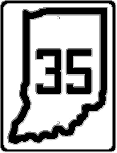
State Road 11 – This road actually ended up not having been part of the Great Renumbering…but it was. SR 11 has a very strange history. According to the original renumbering plan, SR 11 was to connect Columbus to Madison. Now, a discerning reader will ask, rightly so, “isn’t that SR 7?” Why, yes. Yes it is. But SR 7 wasn’t part of the original plan…at least that published by the Indiana State Highway Commission prior to the Great Renumbering. But SR 11 ended up being pasted on a short highway that entered Ohio as Ohio State Road 11. The National Old Trails Road, east from Richmond along the Eaton Pike, was just a continuation of Ohio State Road 11 into Indiana. By 1935, US 35 would be extended into Indiana along SR 11, and the number 11 would be removed from Indiana. For the time being, anyway.
State Road 35 – At the same time that SR 11 was being removed from Indiana, the ISHC found itself in a strange situation. There was already a SR 35 connecting Indianapolis to Mauckport through Nashville, Brownstown, Salem and Corydon. With the coming of US 35, SR 35 would have to be renumbered. This created a situation that Indiana has one three digit “major” highway, since the SR 35 was renumbered SR 135. Any “daughter” roads with a number of 35 are connected to SR 135, not US 35. For instance, the first daughter road of SR 135 was SR 235, which was actually the original US 50 from Vallonia to SR 135. The original US 50 route also used what is now SR 135 from SR 235 to Brownstown.
State Road 33 – In 1938, the American Association of State Highway Officials (AASHO), the keeper of the United States Highway system (they approved new routes, reroutes, and numbers assigned to such), approved the extension of US 33 into Indiana and Michigan. The route used for US 33 would take over SR 527 from Decatur to Ohio, multiplex with US 27 to Fort Wayne, then take over SR 2 from Fort Wayne to South Bend along the original route of the Lincoln Highway. Suddenly, the already existing SR 33 (two parts – 1] connecting Bennettsville to New Albany and 2] SR 62 west of Edwardsville to Mauckport through Elizabeth and Laconia) had to come up with a new designation. ISHC had just the number that would fit into the state highway numbering system: SR 11. Part one mentioned above became SR 111 originally. The Mauckport to Edwardsville section would be given the “major” number of SR 11.
State Road 133 – This road was renumbered at the same time as SR 33. The idea of having a “daughter” road that was nowhere near its “mother” was the prime reason for this. The old SR 133 became SR 111 in 1938. SR 133 (111) connected New Albany along the Ohio River to New Boston.
State Road 136 – 1951 saw another round of US routes extended to Indiana. The first of these would replace SR 34, which connected Indianapolis west to Crawfordsville, Veedersburg and Covington. It was also one of the old routes of the original Dixie Highway. SR 34 would be completely removed from the state system, replaced by US 136, although SR 34’s daughter roads continued to remain for years to come. This would lead to another renumbering. SR 136, at the time, ran northwest from Danville to North Salem, then west through Roachdale, Russellville and Marshall, ending at US 41 north of Rockville. From US 41 east to North Salem, SR 136 basically ran roughly parallel to its “mother” road, US 36. Due to the number 136 being assigned to the new US Highway, the old SR 136 was given the number SR 236. As an aside, US 136 was/is the only US highway that started/starts in Indianapolis. This replaced the former only US highway that started in Indianapolis – US 36 – which was extended into Ohio within a decade of its creation.
State Road 231 – This was a very short, and short lived, state road that connected US 31E north of Jeffersonville across to SR 62 in New Albany. In 1953, an extended US 231 would be added to the state of Indiana, connecting Owensboro, Kentucky, to US 41 south of St. John. This made the renumbering of SR 231 necessary. The number chosen? SR 131. Although the 1956 Indiana Official State Highway map would again list it as SR 231 – but I believe that that was a typo. Because the 1957 map again shows SR 131. SR 131 was removed in 1963, when Indiana finally decided that US 131 wouldn’t end at the Indiana-Michigan State Line. US 131 was Michigan’s extension of Indiana SR 15 for years. It was removed again in 1964, but part of that was that SR 13 would connect to Michigan’s US 131 in the years to come. (And, the fact that the ISHC marked the US highway on the Michigan side of the state line that was an extension of SR 15 as US 103, and the extension of SR 13 is labeled SR 131 in Michigan until it connected to US 131 as US 12.
Two US Highways that would be completely removed from Indiana maps over the years were US 460 and US 641. US 460 basically followed SR 62 from New Albany to Evansville and SR 66 from Evansville to New Harmony. It crossed into Illinois on the New Harmony bridge. US 460 became redundant with the completion of I-64 from Norfolk, Virginia (where US 460 still exists), to St. Louis, Missouri. US 641 was on maps from Evansville across the Ohio River into Kentucky, using the US 41 route and Evansville bridge. From Henderson, Kentucky, north, it was basically a multiplex, and was removed by Indiana. Two US highways were massively truncated over the years. Those are US 27 (truncated at Fort Wayne) and US 33, which now ends at Elkhart.
Greensburg, Indiana. The city that had already been connected to the rest of Indiana via the Michigan Road would become a busy spot on what would eventually become the Big Four Railway. It started with the main line connecting Indianapolis to Cincinnati. Then came the line that connected Greensburg to Columbus – called the Columbus, Hope & Greensburg. Then there was the last connection.
In July 1879, a charter was issued to build a railroad that connected Vernon, in Jennings County, through Greensburg to Rushville in Rush County. At the south end, the railroad would connect to several routes that converged in North Vernon, namely the Madison & Indianapolis and the Baltimore & Ohio Southwestern, connecting Vincennes and Cincinnati. At the north end, Rushville, connections were also plentiful – again with the B&O and the Pennsylvania, in the form of the Cincinnati, Indianapolis & Western (B&O) and the two separate sections connecting Rushville to both Shelbyville and Cambridge City (later Dublin) (PRR).
In October 1879, Colonel Horace Scott, with a group of investors, met with the Directors of the Vernon, Greensburg & Rushville to ask that the directors allow Colonel Scott to have part of the two percent tax to help build the Columbus, Hope & Greensburg. No decision was made at the time. However, it was passed on by Colonel Scott that his goal was to defeat another railroad, and that connections between the CH&G and the VH&R would have nothing but benefits for both companies. (Source: Columbus Republic, 25 October 1879)
The railroad itself was completed between Vernon and Rushville in July 1881. However, it found itself immediately leased to the Cincinnati, Indianapolis, St. Louis and Chicago Railway Company, one of the founding members of the Big Four (Cleveland, Cincinnati, Chicago and St. Louis Railway). The sole operation of the VG&R would be the care of the CIStL&C starting on 1 July 1881. Keep in mind, this was only a lease at the time.
In 1893, M. E. Ingalls, President of the Big Four Railway, went before the State Tax Commissioners to plead the case when it came to property taxes. The VG&R, according to Ingalls, cost $7,000 a mile to build, never earned any money, and could not be sold for over $100,000. The connection line, which connected Rushville to points north (Cincinnati, Wabash & Michigan) as far as Benton Harbor, Michigan, cost $15,000 a mile to build and had never earned a total of $100,000. It was also mention that it was possible that the Columbus, Hope & Greensburg would be dumped by the Big Four, and that another railroad, the Fairland, Franklin & Martinsville Railroad, should be abandoned by the company, since it “has never seen the day when it earned fifty-cents profit.” (Source: Rushville Republican, 22 August 1893) The assessed value of the VG&R, just in Rush County, was $83,285 as of February 1891.
On 29 Jul 1901, the Indianapolis Journal published the railroad property tax assessment reports for the year so far. The Vernon, Greensburg & Rushville was reported to have 44.67 miles of main line track and 8.97 miles of side track, with no second main. For the main track that summer, the VG&R was assessed $6,000 per mile of track by the State Tax Board. The side track was assessed $2,000 per mile. The railroad that year had spent $3,460 on improvements. The company was also assessed $500 a mile for using 52.14 miles of the Baltimore & Ohio Southwestern.
By 1941, passenger traffic was getting pretty slim. The New York Central had applied for the right to abandon trains 139 and 140, passenger runs between Anderson and Greensburg. They were scheduled to be taken out of service on 23 August 1941. That was extended until 30 August 1941. According to the Rushville Republican of 3 September 1941, the abandonment was pushed back indefinately. What made this abandonment even weirder was the fact that the trains to be removed only connected Anderson to Greensburg. The trains that made the run from Elkhart, through Anderson, to Greensburg weren’t on the abandonment list. The newspaper stated that “since the trains were not dropped as scheduled, there is speculation that the railroad may continue the local service.” Service that, at that point, had been running for over 60 years between Greensburg and Rushville.
The VG&R maintained separate stock ownership for many years after the lease started. There are references to stockholder meetings in the Rushville Republican into 1937. Those stockholder meetings were usually held at the Big Four train station in Greensburg. In January 1938, the Big Four asked permission of the Interstate Commerce Commission to consolidate its operations by merging eight railroads into the Big Four proper. Two of those connected at Greensburg: Columbus, Hope & Greensburg and the Vernon, Greensburg and Rushville. This would spell the end of those companies as separate entities, making them officially part of the New York Central Railroad. It wouldn’t affect the Big Four/New York Central much. For all eight companies, only 3,582 shares of common stock would have to be issued to cover the shares of stock the Big Four didn’t own. Those that owned the non-Big Four shares would have a choice: cash or shares.
With the merger of the Pennsylvania and the New York Central in 1968, the Penn Central found itself with multiple tracks running to the same locations. As mentioned above, the PRR met with the NYC at Rushville and North Vernon. The line from Rushville to Greensburg stopped appearing on Indiana Official Highway Maps in 1976. The section from Horace to North Vernon would be removed from the state maps for 1985. From Horace to Greensburg would disappear, at least according to state maps, in 1991.
Today, we focus on a state road in western Indiana, part of which might have been a United States Highway had it not been for construction between 1924 and 1926.
1926 Newspaper listing for the new SR 59.
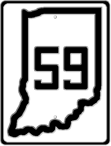
The official description of the highway is as follows: “State Road 59 – Linton north to Grange Corner in Parke county be way of Jasonville, Rowesville, Clay City, Ashboro, Brazil, Rockville and Marshall. (Known now as State Road 9 except the Brazil-Rockville section which is new road.” It should be noted here that the newspaper articles and the post Great Renumbering 1926 Official State Highway Map listed Howesville as Rowesville. On the 1929 Official State Highway Map it was done correctly, listed as Howesville.
The road was divided into two parts when the Great Renumbering happened. The northern section, from Grange Corner to Rockville was, from 1920 to 1923, part of State Road 10. SR 10 would become part of US 41. Sometime between 1923 and 1926, SR 10 was rerouted to bypass the center of Rockville, skirting the edge of town. The old SR 10 route would be changed to SR 9 to match the Linton to Brazil section.
All this jockeying around of roads didn’t matter in the end. By 1929, SR 59 would go nowhere near Rockville, leaving Brazil due north ending at Bellmore and the section that existed in 1926 from Rockville north would be returned to county jurisdiction. I guess you could say it was the first road abandoned by the Indiana State Highway Commission. Looks like I will covering that as some point.
Near the end of the 1910’s and into the early 1920’s, as the Indiana State Highway System began to really take shape, an important road the skirted Indiana’s northern shore became part of the all important road system. Prior to 1920, it had been known nationally, at least according to Rand McNally, as the “Detroit-Chicago Pike.” That name was given to the road between the two title cities, and the road stayed in Michigan for as long as possible before dipping into Indiana. Locally, however, it was known for years as both the Old Chicago-Detroit Pike or, more recently, the Dunes Highway.
When the Dunes Highway was taken into the state highway system in 1920, it was given the number 43. One of the things that made the original State Road 43 different is that by 1923, with the first renumbering of state roads in Indiana, SR 43 was completely paved from the Illinois State Line to the Michigan State Line. Only one other road in Indiana was paved for its entire route through the state – State Road 3, or the National Road. The Dunes Highway was 18 feet wide for its journey through Indiana. At the time, that was tight, but it was pretty much standard for road widths in the early 1920’s.
When the Great Renumbering occurred on 1 October 1926, the Dunes Highway was given a United States Highway designation…two of them, as a matter of fact. The entire route was numbered US 12, since that was the number given to the route connecting Chicago to Detroit, which this route had done since its early history. The other number that the road acquired, from Gary to Michigan City, was US 20.
It wasn’t long before Indiana State Highway Commission officials, and local officials along the Dunes Highway, figured out that tourist traffic coming along two major US Highways was swamping the narrow passage that formed the highway. In September 1930, plans were put in place to fix the situation. Well, sort of.
The plan would cost $2,000,000 for a road 30 miles long and 40 feet wide. The new route would connect Gary to the Indiana-Michigan State Line, generally located between 1/2 and 1 1/2 mile south of the Dunes Highway. The new road would be given the name “Dunes Relief Road.” The plan would be to move US 20 to the new road upon completion, with a new state road number given to the eastern end of the new road that connected the then US 20 (Michigan Road) east of Michigan City to US 12 just south of the state line. This new road would be called SR 212.
Snippet from the Indiana Official Highway Map of 1 August 1930. This map was essentially the 1931 Official, although it was labelled 1930. This map shows the Under Construction status of the Dunes Relief Road between Springville and Chesterton, and shows the authorized addition of the continuation of the road to Gary.
The Indiana Official Highway Map of 1930, Late Edition (there were two maps issued in 1930, one for January, and one for August), shows construction already marked for the pending road. The Dunes Relief Road would bypass Michigan City to the south and the east. Since it would become US 20, a major US highway, the thought was that this would take major traffic off of city streets in Michigan City. And that in itself was a bone of contention for those in charge in the area.
Michigan City saw itself, rightly so, penalized by the removal of the major traffic of US 20. In late March 1932, preliminary approval was given to two bond issues by Michigan City to widen US 12 east and west of the city to 40 feet. East of the city, the newly widened US 12 would connect to the newly finished Dunes Relief Road at SR 212 near Springville. The ISHC was looking forward to such a development, since the state commission had, to that point in history, no jurisdiction on any road inside limits of any town or city in the state. State highways connected the towns…from the limits of that town to the limits of the next town. It was up to the city in question to improve a route, chosen by the city, to become the state highway through the area in question. This would change shortly after this, when the ISHC was allowed to take over city streets for maintenance. (Source: Porter County Vidette-Messenger, 29 March 1932)
At the western end of the new planned road, Gary’s Mayor, Roswell O. Johnson, referred to the new route as the “Grief Road.” Since it would connect back to the Dunes Highway at the Gary city limits, it was thought that no relief of traffic would be realized by Gary and Hobart. Both of those cities, as well as other local officials, were in favor of a superhighway called the “Three-State Highway,” connecting LaPorte to Gary, and along the southern edges of Gary and Hammond. A delegation of local officials appeared to approve at a rate of 90% the building of the Three State Highway. ISHC officials were unmoved. Detailed plans had been completed, and contracts were let for the original planned Dunes Relief Road. (Source: Munster Times, 18 September 1930)
Things with the Dunes Relief Highway got a little dicey in Pine Township, Porter County, five miles west of Michigan City. The Michigan Central Railroad was being encouraged to build a viaduct along the new Dunes Relief Road over their tracks. According to the railroad, the viaduct was being held up by the crossing of Schmidt Road, which was 400 feet west of the proposed viaduct site. Porter County officials wanted nothing to do with closing the road. As a matter of fact, a survey was being done on two miles of Schmidt Road for plans to improve the route. It was pointed out that a) the only way the road would be closed is by ruling of the Indiana Public Service Commission (since it involved a railroad) and b) people living along Schmidt Road preferred the Dunes Highway route to Michigan City over the pending Dunes Relief Highway. (Source: South Bend Tribune, 22 November 1931)
The new US 20/SR 212 would find itself completed by 1932…or least according to Indiana Official Highway Maps. The Dunes Relief Road is still being used today, called the Gary-Michigan City Highway on Google Maps. Most of the route today appears to be four or five lanes wide. Both the Dunes Highway and the Dunes Relief Road serve their functions quite well almost a century later.
After the formal (second) creation of the Indiana Highway Commission, the race was one to create a state highway system that connected all of the County Seats in the state together. The ISHC was tasked, from the very beginning, to connect all county seats and towns of population of 5,000 or more. There were a lot of places that were set to be connected to the state highway system. But, the state also had a limited amount of both funding and mileage allowed. This led to sort of a competition between routes to be added to accomplish that goal.
Then came the new route, to be called SR 22, that was announced in 1920.
The ISHC simply stated “Route 22. Beginning at Bedford in Lawrence County running thence in a northerly direction through Bloomington and Martinsville to Indianapolis.” (Source: Martinsville Reporter-Times, 1 July 1920 and Indianapolis News, 30 June 1920) Now, discerning readers (i.e. those that read my post of just two days ago) will be quick to point out that the route from Martinsville to Indianapolis was covered by the then Dixie Highway, which is roughly SR 37 today. One would think that route would be chosen for the final section of SR 22.
Unfortunately, politics, and the law creating the ISHC, got in the way.
Martinsville is the county seat of Morgan County. It goes without saying that Marion County’s seat is Indianapolis. A (more or less) direct route between the two made absolute sense. However, the second stipulation came into play. Both newspapers mentioned above, which printed the very same story word for word, reported “A hearing was given to Mr. Charles Mendenhall and others interested in the location of the state road connecting Martinsville and Indianapolis. They made a plea for the road to run through Mooresville, which was taken under advisement.”
Mooresville, in 1920, only had a population of 1,781. There were no larger towns between Martinsville and Indianapolis. A population of around 2,000 made Mooresville, relatively, a large town in the state at the time. Mooresville was already connected to Indianapolis via both the Indianapolis-Vincennes State Road (future SR 67) and the Indianapolis & Vincennes Railroad (actually, in 1920, this was part of the Pennsylvania Lines West of Pittsburgh, having been part of both the Vandalia and the Panhandle).
The whole thing came to a head with a hearing on 16 June 1920. “A hearing on the definite location of the state road between Martinsville and Indianapolis was given. Charles Mendenhall spoke for the route through Mooresville to Indianapolis, and Emmett Branch spoke in favor of what is known as the Bluff road. Judge McNutt, of Martinsville and Mr. Buchanan, of the postoffice department, Indianapolis, also sope (sic) in favor of the Bluf (sic) road.”
There were two differing factions when it came to locating the new SR 22. One favored a route west of White River, the other favored east of the river.
In the minute book of the meeting to determine SR 22’s location, on the same day, it was noted “moved by Mr. Crawford, seconded by Mr. Oliphant, that the state road connecting Martinsville and Indianapolis be located through Mooresville, through West Newton to Indianapolis. Motion carried unanimously.”
The selection was submitted to Governor Goodrich, whom had the job of approving all roads taken into the state highway system. The Governor approved the selection.
The newspapers make the following statement about the selection: “The route has been changed two of three times, at present the Mooresville road is it, but a good many people are wondering when the next change will be due and if when the final change is made, it will go straight up.”
Thus, the route to Bedford would march its way through Mooresville, crossing the White River west of Martinsville, where it would follow the Dixie Highway south to its end. It wouldn’t stay this way long. The old Indianapolis-Vincennes State Road from the White River bridge into Martinsville was given the number SR 12. By 1923, SR 22 was, in fact, moved to “go straight up.” The Dixie Highway was taken over as SR 22. The rest of the old Vincennes Road from Martinsville to Indianapolis would be changed to SR 12, matching the rest of the old route. The connecting bridge between SR 12 and SR 22 at Martinsville would remain part of the state highway system, albeit without any number that I can find.
When the Great Renumbering happened on 1 October 1926, SR 22 became SR 37, SR 12 became SR 67 and the connecting bridge was given the number SR 39. This SR 39 was disconnected from the rest of the same numbered route, and would be for years. But, having been in the state highway system for six years at that point, it explains why that small section of road was included at all.
EDITOR’S NOTE: Some may wonder why I am covering this topic so close to covering the Dixie Highway in Morgan County. The two ideas are really unrelated. I wanted to do an entry about expansion of the state highway system between 1919 and 1923. So, in that vein, I pulled up, on newspapers.com, articles with “state road” and “1920” in the search box. The articles mentioned were near the top of the list, and caught my eye. So, the original planned entry is still in a holding pattern as I wrote this one. This shows how the entry list here at ITH is never really set in stone. I tend to refer to it as set in mush. Now, if you excuse me, I am going to take my short attention span and see what else catches my eye while trying to nail down a specific idea.
The Lawrenceburg & Upper Mississippi Railroad. Or, as it was originally chartered, the Rushville & Lawrenceburg Railroad. Chartered on 16 February 1848 by the Indiana General Assembly, the railroad was designed to connect, ultimately, Indianapolis to the Ohio River at Lawrenceburg. It acquired its second name with a name change on 21 January 1850. The same year that it completed the tracks between its title cities, 1853, the railroad changed its name again to Indianapolis & Cincinnati Railroad.
The Indianapolis & Cincinnati decided to build a railroad yard just outside the city of Indianapolis. At that time, just outside the city was at Dillon Avenue…also known as the connection to the Shelbyville Road north of Virginia Avenue. The station for the railroad was along the line, due east of what is now Union Station, between Delaware and Alabama Streets. Essentially, the line of Louisiana Street was the Indianapolis & Cincinnati until the railroad turned southeast about 3/4 of the way across the half-square between what is now Shelby Street and State Avenue. Here, the railroad would build a maintenance and storage shop.
By 1870, the area south of what became the PRR and B&O to Prospect Street, from Dillon (Shelby) Street to Reed Street (State Avenue) was devoid of anything other than a railroad yard. Originally known as the I&C Yards, it would become the Indianapolis, Cincinnati & Lafayette Yards after the 1867 merger of the Indianapolis & Cincinnati and the Lafayette & Indianapolis.
1870 map of Indianapolis showing the Indianapolis, Cincinnati & Lafayette Railway yards at Dillon (Shelby) Street.
With the creation of the Union Depot, the yard would become very important in the clean up of passenger cars. It served this purpose for the I&C, the IC&L, its successor the Cincinnati, Indianapolis, St. Louis & Chicago Railway, and its successor the Cleveland, Cincinnati, Chicago & St. Louis Railway (Big Four). The city had essentially expanded around this yard.
1898 Sanborn Fire Map of the Big Four Yard (later Leota Yard or Coach Yard) at the Big Four Cincinnati Main Line and Shelby Street. The Leota Yard name would come from the street that crossed in the middle of the yards.
By 1898, the Big Four Yard, as it was known, stretched for a half mile between Shelby Street and State Avenue, with four tracks crossing State at Deloss. These four tracks would include access to the repair yard, north of the main line, two mainline tracks, and access to the roundhouse south of the main line. There would also be a track crossing both Lord and Shelby Streets for direct access to the roundhouse from the west. The roundhouse itself contained 38 stalls. The yard would later be named after the street that ran through the middle of the facility, which was later removed: Leota Yard.
With the creation of the Big Four facilities at Beech Grove, most of the maintenance duties left the Leota Yards. After that transfer of duties, Leota became known as the Coach Yards. Maintenance and clean up of passenger rolling stock would be taken care of at the yard, being around a mile from Union Station. The Cincinnati main line would run basically due east from Union Station, through Leota Yards, and then southeast towards Beech Grove and Cincinnati. The main line was moved, with new tracks connecting to the PRR/B&O just east of College Avenue. The tracks coming due east into Leota Yard were made a secondary, and were stub ended before crossing Virginia Avenue on the west end.
1937 MapIndy Aerial photo of Leota Yards. The tracks with the light colored ballast, running from upper left corner to lower right corner is the Big Four/New York Central’s Cincinnati Main Line.
Between 1956 and 1962, most of the facilities at Leota Yard would be gone. This coincides with the creation of the Big Four Yards at Avon. The roundhouse, according to aerial photos taken in 1962, had been removed, as have most of the tracks and other buildings. All through traffic coming through the old yards was coming along the northern main, with switching traffic using the old main to get to companies like Goodrich, which was located at East and Louisiana. The only remnant of that track that still remains is on a bridge over Interstate 65/Interstate 70 south of the Bates Street bridge. That is actually only the ties today.
1962 MapIndy Aerial photo of the former Leota Yards. The main line and a branch line to Goodrich is almost all that remains of the facility at that time.
In 2019, the latest that aerial photos are available as of this writing, very little remains of the old Leota Yards. The floor of a few stalls of the old roundhouse can be see in the grass that has overtaken the site, a stub of railroad track still exists…connecting nothing east of Shelby Street to nothing east of what would be Leota Street. One of the water tower stands, along the south property line next to the old roundhouse can still be seen. And, if you drive slowly north bound on Shelby Street just after passing the alley that marks the old south property line, you can still see a concrete marker dated 4-14-17 denoting the property of the CCC&StL. That can be seen in this Google Street View image.
2019 MapIndy Aerial photo of the former New York Central Leota Yards. The street running through the old roundhouse area was built sometime between 1972 and 1978.
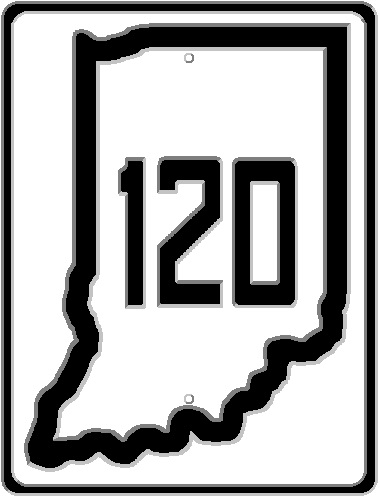
Along the northern tier of Indiana counties, from Elkhart (city) to the Indiana-Ohio State Line east of Fremont, there is a state road that was a late comer to the Indiana highway system. SR 120 was numbered to be a daughter to US 20, and for the most part, it is. For a little while, though, it wasn’t.
For most of its route through Indiana it is known as Vistula Road. Vistula is an unincorporated place in Elkhart County, northeast of Bristol, almost in Michigan. Vistula Road, however, doesn’t go there. But that is not where the road got its name. Vistula used to be the name of another town, that happens to be on the road. The name of the town was changed to the name of the river on which Vistula was located – Elkhart.
The road was, in its early days, known as the Territorial Road, and “was probably the first cross country highway connecting the New England states with the territories of the mid-west.” (Angola Herald, 20 Jan 1954) It was a Native American trail that connected Lake Michigan (near Chicago) through Toledo and Sandusky to Fort Duquesne (Fort Pitt), now Pittsburgh, Pennsylvania. This road that was made into SR 120 in Indiana actually predates the United States by 75 years. It acquired its first name, and the name it still uses in Michigan, “Territorial Road,” around 1816. Therefore, the road was under French, English and American jurisdictions (in that order) when it came to the European powers in the area.
SR 120 started showing up, as itself, on Indiana Official Highway Maps in 1937, as an authorized addition. There were, however, two sections that predate SR 120 and the authorized addition. Out of Elkhart, connecting to Bristol, was a state road that was added in 1932 known as SR 19. SR 19 connected to SR 15 at Bristol which took it closer to Vistula than any other state road would get. SR 15 would eventually become US 131…for a while. In 1936, SR 19 between Elkhart and Bristol became SR 319, as SR 19 was the number given to the road that was US 112 leading north from Elkhart.
1937 Indiana Official Highway Map showing SR 120 as an authorized addition to the state highway system.
At the Indiana-Ohio State Line end, SR 827 into Fremont was being constructed to the due east to the state line. That was in 1936. 1937, SR 827 would be completed to the state line, and SR 120 would be shown as a connection route between Bristol and Fremont. The SR 120 route would not appear on the 1938 map, but would be back, in almost full completion, on the 1939. On that map, it connected SR 13 to SR 3 at Brighton, and Orland to the state line. At Elkhart, it was still SR 319.
Between Brockville (now Fremont) and Willow Prairie (now Jamestown)
By 1941, SR 120 would extend for the entire length. It should be mentioned here that the original Vistula Road connected to the Lincoln Highway between Mishawaka and Osceola. That road is broken up by the Elkhart River, but it continued along Indiana Avenue in Elkhart County, turning onto Franklin Street, following that, Vistula Street and Jackson Boulevard until it connects to what is now SR 120 at Middleton Run Road. Middleton Run Road was actually SR 120 when it was completed in 1941.
Even though SR 120 was essentially replaced by the Indiana Toll Road (I-80/90 was later assigned to that route), the ISHC, and later INDOT, kept it in place. There are some people that question this, mostly due to the truck traffic avoiding the toll road. Keep in mind that as long as a road has a state road marker on it, unless specifically forbidden, is a truck route. And the only reason that turcks would be banned is for safety reasons…such as the fact that SR 9 in Shelbyville goes through Public Square which won’t fit a truck really well. SR 120 doesn’t fall into that category.
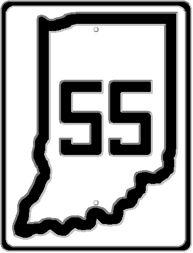
Today’s Road Trip 1926 focuses on a small state road that would eventually become a bit longer…and now kind of replaced. (What is it with roads ending in “7” and I-69 taking over? US 27, SR 37, SR 57?) The official description, as published in the newspapers in late September, 1926, is as follows: “State Road 57 – What is now known as State Road 28, from Petersburg to Bloomfield.” The maps that I made show SR 57 ending at the new SR 54 west of Bloomfield. SR 54 ending in Bloomfield itself, so it is possible that SR 57 multiplexed with it into Bloomfield. Either way, SR 57 was about one mile from connecting to SR 67, giving access to Indianapolis and beyond.
Over the past almost six years, while researching topics for both the Facebook group and this blog, I have found a lot of things that were interesting, yet wouldn’t make a complete entry for this blog. This includes a lot of things that I have snipped from newspapers that I have shared in the group. Some of those are one off items that I found interesting. Today, I want to share some of those.
This picture appeared in the Indianapolis News on 4 October 1960. It was part of a larger advertisement by the Portland Cement Association about the opening of Interstate 74 from what would eventually become I-465 to Shelbyville that had just opened. It states very bluntly that the “Old Michigan Road” was replaced by the new interstate. The Michigan Road, in that section, had been in place for around 130 years or so, but now found itself not only relegated to becoming a frontage road, but also completely removed in one section from Acton Road to London Road, when the interstate was built directly on top of the old right-of-way. I found this picture recently (26 February 2020), although I covered the topic (“Replacement of US 421 in Marion, Shelby and Decatur Counties“) on 19 July 2019.
Another tidbit I found on 26 February 2020 involved a topic that I have covered several times in ITH. SR 100 was originally planned, though not built, as a bypass of the city of Indianapolis in 1932. Eventually, when I-465 was built to replace SR 100, the Federal Government paid 90% of the cost. But the section that is now 465 from 62nd Street to north of 96th Street on the west side wasn’t included in the original design. At that time, state roads were paid by the Feds in a 50/50 arrangement. When the state decided to connect the two sections of 465 with this new road, it was built as SR 100 (hence the location of Park 100!). The state, therefore, paid half the cost. It lasted as SR 100 for about a year, before it was recommissioned as I-465, creating a 25 year confusion with the “dogleg,” which was the actual 465 in the beginning.
Proof that INDOT still believes that the section of 465 that connects the north leg to the original west leg is an afterthought is shown in the signage that INDOT itself installs. This sign is located at Township Line Road on -465 West. Notice that the destination on the sign shows I-465 South, and that the mileage to I-65 North is listed. This sign was probably put in place in the late 1960’s when the interstate was constructed. I want to mention that this picture was taken in April 2019, after the sign was just replaced by INDOT and I-865 had existed for around two decades. (The sign wasn’t actually replaced. All of the signs in that section were covered over with segments that were riveted to the old sign, those lowering the cost of replacement.)
When I started the ITH blog, one of the first articles talked about how US Highways are merely state roads. (“US Highways: They are actually State Roads,” 12 February 2019) This is shown when it comes to signs that INDOT install along these roads. The pictures shown here come from the Pleasant View interchange with Interstate 74/US 421. Or State Road 421, depending on which sign you look at. The first of these two pictures shows not only a SR 421 marker on the BGS (big green sign), but also a US 421 trailblazer on the right shoulder closer to the exit. 421 has this signing situation in numerous places along its route. It should be noted that the sign that shows the SR 421 marker is newer than that of the one with the US 421 marker. This can be seen by the fact that the directions use smaller upper case letters, as is now Federal standard.
An article from the Indianapolis Star of 24 August 1944 shows the contract for the final section of US 40 that needed widened to four lanes has been let. 10.75 miles of the road, from Dunreith to Dublin, were all that was left of making US 40 across the state into a divided highway. Notice that the road was to be 22 feet wide and made of concrete. The paving company that won the contract, Calumet Paving Company, still exists today as Calumet Civil Contractors, Inc. (www.calumetcivil.com) According to its website, the company started in 1928 and its first project was SR 6 in Gary.
References to the Madison & Indianapolis State Road still exist in legal descriptions. The above snippet shows a property description in Franklin which still uses the original name of the road that would become, later, Original State Road 1 and, hence, US 31.
The Jeffersonville, Madison & Indianapolis Railroad is also still listed in property descriptions in Franklin, as well. This, to me, is strange, since the JM&I was actually a later company name for what was the Madison & Indianapolis Railroad. For an idea of the age of this reference, the railroad would later become known as: the Pittsburgh, Cincinnati, Chicago & St. Louis (Panhandle); the Philadelphia, Baltimore & Washington; the Penn Central; Conrail; and now as the Louisville & Indiana. The last two snippets were published in the Daily Journal of Franklin concerning construction work at the Masonic Home.
When I was writing a blog entry concerning Indiana Toll Roads (“The Indiana Toll Road(s),” 25 May 2019), +I found this article concerning the possibility of building a toll road from Chicago to Miami (you know, basically a toll version of the Dixie Highway!). I am sure that the concept of a $2 billion highway was frowned upon when this editorial was written for publication on 28 September 1953. When the interstate system came into being less than three years later, the need for such a mammoth project, as a toll road, declined.
I am currently digging through my backup DVDs/BluRays to see if there are even more things along this line to share. I welcome any comments that you may have.
Much has been made about an idea in the early 1960’s bringing Interstate 69 to downtown Indianapolis. Many people believe that having the I-69 route connecting directly to downtown would alleviate much of the congestion that occurs on I-70 and I-465 with people trying to get back and forth to locations northeast of the heart of the city. I am of a different view on that perception. But that’s neither here or there at this point. But the idea of the “Interstate 169” wasn’t the first such plan that was shut down by the Federal Bureau of Public Roads.
It should be noted that the original plan for the entire interstate system was to provide access routes between cities for National Defense purposes. The law of 1956 creating the system was later relaxed to allow for the highways to “conform more to the needs of the various communities.” This change would allow for the interstate system to serve the public, as well as the Defense Department. So, when originally created, Interstates 65, 69, 70, and 74 would get you in the general direction of Indianapolis…not completely to the city itself. After the relaxation of the rules, the plan in 1965 called for the system to include “I-465 (the outer loop); an inner loops comprised of I-65 and I-70, both stretching beyond the county boundaries; I-74 which connects with the northwest and southeast edges of the outer loop, and I-69 which joins the northeast corner of the outer loop.” (Indianapolis Star, 06 November 1965)
It should also be noted here that the original plan for the end of I-69 was very different. The original route of I-69 was planned to connect to a point on Interstate 70 near 21st Street and German Church Road. This would have brought the interstate through the Geist area to connect to a point in Hamilton County in the area of 126th Street and where I-69 is today. Travel to downtown would have been much different had this plan been put into place.
Anyone that has looked at the “north split” of Interstates 65 and 70 can tell that there was more to the plan than what exists. There are bridges over ghost ramps, and ghost ramps, that were started and left to rot. The Indiana State Highway Commission had pushed for the idea of connecting the northeastern part of Marion County to the interstate system very early. The push was a continuation of I-69. But one thing that most people don’t take into consideration is that all of the interstate plans had to be approved by the Federal Bureau of Public Roads, since the Feds were footing most of the bill.
One of the first modifications to the original plan to cut down on the costs was to combine interstates 65 and 69 north out of downtown. The Indianapolis News of 15 May 1962 reported that “I-65 and I-69 Routes in City Get Restudy.” The original plan, and the one that was ultimately built, brought I-65 across the 12th Street corridor to meet I-70 coming in from the east side. The original plan for I-69 was to have it end in the northeastern of the county, as it does. The I-69 plan, added to by the state and city officials as a wish, was to leave due north from the north split, then turn northeast to meet with the Fall Creek Parkway corridor between 30th and 38th Streets.
A plan submitted to the Bureau of Public Roads wold have brought I-65 across the city along, roughly, the 30th Street corridor to meet I-69, then turn south to meet I-70 near 12th Street. This new plan would, in theory, reduce the cost of building the interstates by $4.8 million. This new study was “prompted by the federal bureau, which questioned whether I-65 and I-69 should parallel each other.” The study was submitted to the Chicago regional office of the Bureau on 15 May 1962. It was expected to be rule on by that summer.
The Bureau of Public Roads questioned the necessity and cost of bringing Interstate 69 into the downtown area. Even with the new duplex plan. But by July, the Bureau had verbally denied teh idea. The state was considering an appeal of the decision. The Indianapolis News of 14 August 1962 reported that the state was submitting a request to end I-69 just south of Castleton if the plan to bring it downtown was not approved. The state, if they couldn’t get a route to downtown, determined that travelers would be better served if I-69 would connect to a point near the two legs of SR 100 (82nd Street and Shadeland Avenue) where I-465 would be built. This would bring motorists to the SR 37 corridor, which was built in the mid 1950’s, allowing access to downtown. Another thought was that the new plan would allow for continuation of the highway, should it be approved at a later date, to downtown instead of ending it on the far eastside.
The request in August was submitted because the plans being mulled over by the Bureau was delaying engineering work on the entire highway system. Such work had been stalled to allow for any changes to be implemented. Without those changes forthcoming, nothing was getting done. The state was anxious to get the ball rolling when it came to the interstate system in Marion County.
The state had, according to the Indianapolis News of 25 October 1968, asked for more interstate mileage. One project was, again, the much wanted, and often denied, Northeast Expressway project as an extension of I-69. As pointed out in the article, the tri-level interchange at the north split was also planned, and adding I-69 to the mix wouldn’t require any type of redesign. Another project would connect the south leg of I-465 to I-65 near 38th Street along roughly the Harding Street corridor on the city’s west side. This project would have also contained an extension of I-65 across the 12th Street corridor to connect to the new Harding Street highway. And yet another project was asked to be added at that time would be a connector route across the 30th Street corridor connecting I-65 to the asked for I-69. These expansions, called “the first formal request for additional interstate mileage since the birth of the expressways about 12 years ago,” were shot down…at least the Indianapolis projects. (There were other requests at that time, and I will cover those later.)
I have seen news stories about the possibility of bringing Interstate 74 from Speedway to downtown. That project never got past the city recommendation stage. It would have connected to the extended 12th Street corridor of I-65, then aiming toward the interchange with I-465 on the northwest side. This was in conjunction with a requested change in the I-65 route from downtown to 38th Street. The proposed change would have had I-65 moved to west of White River, to follow the route of the proposed SR 37 (Harding Street) Expressway. (Indianapolis Star, 26 August 1965) The 12th Street corridor would have been extended to west of White River, then I-65 would turn roughly north along the Lafayette Road corridor, behind Marian College (University) to 38th Street. Before turning north, the “future I-74” would connect to I-65’s proposed route. None of these plans, obviously, came to fruition.
Over the past year, Indiana Transportation History has covered quite a few topics. Today, I want to focus on those articles that have been published so far when it comes to railroad history. Railroads have played a major part in the history of Indiana. Indianapolis, the Hoosier capitol, was legally just a town before the Madison & Indianapolis Railroad came to town in 1847. That same year, Indianapolis was made legally a city. Places like Fort Wayne and Logansport became major hubs when it came to railroads. Some have come, some have gone. All have played their part in building the Indiana we have today.
This article is essentially a lot of links, 59 of them to be exact, but it does go to show how much railroads were not only covered on ITH, but how important they were to Indiana in general.
The entire state was covered on 27 January 2020 in an article appropriately named Indiana – A Rail Center.
The first long distance railroad in Indiana was that of the Madison & Indianapolis. The company itself was set up and run by the state of Indiana. It saw both good times and bad during its history. Some of those bad times had as much to do with the management of the company as it did with the actual physical constraints set in place when Madison was chosen as the starting point. Two railroads (Shelbyville Lateral Branch and the Knightstown & Shelbyville), abandoned very early in Indiana railroad history, would play into the Madison & Indianapolis and its competitor (and ultimate buyer), the Jeffersonville. The M&I also found itself with an increased mission, covered in Expansion of the Madison and Indianapolis Railroad.
But the M&I wasn’t the first railroad in the state – that was in Shelbyville, and covered in Indiana’s First Railroad.
Of course, it wasn’t the last time that I covered rail crashes. Major Indiana Railroad Disasters up to 1903 came about as a follow up to the Big Four Special crash mentioned above. 1968 also saw the Train Wreck at Dunreith, a large Pennsylvania Railroad crash that, in my mind, saw what was to come with the pending Pennsylvania – New York Central merge that would become official one month later. Another crash was covered in 1883: Train Wreck Near Salem.
Indianapolis, home of the first Union Depot in the United States, was covered several times on just that subject. Indianapolis Union Depot was the first such building. The combination of the trackage at the station was covered in an article called Indianapolis Union Station: How the Tracks Came to Be. I also spent time covering what was in place Before Indianapolis Union Depot, listing the stations that existed before they were consolidated into the Union Depot. And of course, the ultimate project when it came to Union Station would include Indianapolis Track Elevation.
What is now the Indiana Railroad was covered in a more detailed history called the Indianapolis Southern Railway. As a side note, the name of that company would be referenced in 1987 when the City of Indianapolis closed Bluff Road to replace an old bridge over the Indianapolis Southern Railroad, even though at that time it was the Indiana Railroad. The Indianapolis Southern was also affected by nature, as covered in White River on Indianapolis’ South Side, and its Effects.
Most of the railroads in Indiana were part of what could be considered “eastern” railways. But I did cover one of the “western” roads when I talked about The Milwaukee Road in Indiana.
Of course, Interurbans were covered in great detail, as well, since they played a very important, albeit short, part in transportation history in the state. Indiana Railroad (1930) was the company created to control most of the Central Indiana traction companies. Indianapolis and the Interurban covered how the electric traction companies entered the city, since they legally ended at the city limits.
When the Great Renumbering occurred on 1 October 1926, the new United States Highway number 41 left Evansville aiming due south. At that time, there was a ferry across the Ohio River, allowing passengers to connect to the rest of the country via US 41 through Kentucky. For a brief time in 1930, US 41 was rerouted along the Ohio River, crossing via a ferry directly into Henderson, Kentucky. By 1932, it was back to the old route, due south of Evansville…and still using the ferry. Bridge construction was on the minds of the people on both sides of the river. It took a while…but it happened.
What most people don’t understand about the Ohio River at Evansville is that 1) there are actually two crossings…one in entirely in Kentucky and 2) crossing the Ohio River required not only the states to agree, but also the Federal Government. The legal state line separating Kentucky and Indiana is the low water mark of the Ohio River on the north side of said river. At Evansville, that low water mark is actually north of the main channel of the river. A channel separates the state of Indiana from Green River Island, which is entirely in Kentucky. The actual location of the state line makes me question the whole financing deal with crossing the river. Indiana and Kentucky tend to share the entire cost of bridges across the Ohio 50/50…even though most of the river, 80% or more, is in Kentucky.
Crossing the Ohio also requires permission from the Army Corps of Engineers due to its use as a major water highway. From Pittsburgh, Pennsylvania, to the place it empties into the Mississippi River, the river falls into a Federal jurisdiction. Which makes sense, actually, since the river forms the state lines between West Virginia, Ohio, Kentucky, Indiana and Illinois along its course.
The first mention of a bridge at Evansville was before the Great Renumbering. The Muncie Star-Press of 31 December 1924 mentions that the United States Senate had passed a bill allowing for the construction of three bridges across the Ohio River: one at Evansville; one connecting Portsmouth, Ohio, to Fullerton, Kentucky; and one from Huntington, West Virginia, to a point in Ohio opposite.
There were several attempts to bridge the Ohio River as part of US 41 in the years leading up to the final construction. Newspapers in 1928 were all covering a new law being pushed through Congress for that very purpose. According to press reports at the time, the building of a bridge in the area “has been the cause of heated discussions at Evansville for a year or more.” One solution was the “reported formation of a private company to seek a federal franchise for a toll bridge at Evansville.” This is after “other private efforts to build the Ohio river bridge at Evansville have failed.” In December, 1927, the Indiana State Highway Commission turned down three private offers to build a bridge. ISHC Director John D. Williams issued a statement “to the effect that a provision for private financing of public bridge projects, such as the Evansville bridge, would be an aid to the commission, in that it would not tie up a large part of the available funds in one project.”
In 1928, a hearing for a temporary restraining order against building the Ohio River bridge at Evansville was to be held on 20 October 1928. It was filed along with and injunction suit in Marion County Superior Court. The suit and restraining order was asked for by four Evansville residents and the directors of the Hoosier Motor Club. The argument was that Indiana would be paying half the cost of the bridge which would essentially be a loan to the Commonwealth of Kentucky since Kentucky would be collecting all of the toll revenue. That revenue would be used, it was argued, to repay said loan. “The suit said approval of the interstate contract was made ‘unlawfully and without warrant or authority in law.'” A suit by the Commonwealth of Kentucky would be heard by the United States Supreme Court wanting to have Indiana follow the terms of the agreement for financing the bridge. This put the former suit on hold until the Supreme Court ruled. The Supreme Court did rule on 19 May 1930, requiring Indiana to carry out said contract.
30 September 1930 Indiana Official Highway Map showing US 41’s temporary route along the Ohio River.
It wouldn’t be until October 1930 that contracts, totaling $2,079,866.24, were let for the bridge to be built. The bridge itself would be massive. According to reports, with the opening of the bridge, the structure would total 5,395 feet with a curb width of 30 feet. “Main cantilever superstructure has four spans of 540, 600, 720 and 432 respectively, or a total length of 2,290 feet.” The bridge would have a navigation clearance of 45 feet above the level of the Ohio River at the time of the flood of 1913. That was, at the time, the highest recorded flood of the Ohio at that point. The piers for the bridge dive 80 feet below low water level. The approach spans were also mammoth: south approach was 2,038 feet; and the north approach was 1,063 feet.
It was also mentioned that although the bridge is entirely in Kentucky, the cost for the structure was shared equally by both states. This “has been the cause of many heated words, especially in the Hoosier legislature, but the two states’ highway officials reached their agreement in a friendly, peaceful conference.”
The bridge’s opening ceremony would span several days in the beginning of July, 1932. Evansville and Henderson, Kentucky, would have multiple groups celebrating the opening of the new span. The new bridge would require tolls to be paid to use it. These tolls would be in place until 20 March, 1941, when an agreement between the two states allowed the bridge tolls to be removed. Although the last Kentucky bond for the bridge would be paid off on 1 January 1941, the agreement to continue tolls until March would be for Kentucky to recoup maintenance costs of $216,8383.37.
Indianapolis Star. 3 July 1932. Three days of opening ceremonies for the new bridge to start that day.
A contract was let in February 1936 to the Swanson-Nunn Electric Company of Evansville to install navigation lights on the structure. There was no completion date set for the $4,569 contract.
The bridge that opened in 1932 would serve dutifully until it was decided that a second, parallel structure, was needed. This new facility would cost $5.5 million dollars. It would be located 150 feet downstream from the first bridge, and would carry southbound US 41 traffic to Kentucky, with the old bridge being used for northbound travelers. Both bridges would be configured for two lanes of traffic, even though the original bridge was configured to carry three lanes. Financing for the new bridge would be shared by the Federal government (50%), with Indiana and Kentucky sharing equally the rest of the cost, “even though the Ohio River is in Kentucky.” This was due to US 41’s status as a “primary” highway as opposed to being an “interstate” highway. The contract for the substructure of the second bridge was announced in newspapers on 27 June 1962.
The status of the “Twin Bridges” between Evansville and Henderson are currently in flux. There are many differing plans concerning the spanning of the Ohio River by Interstate 69, which ends, as of this writing, at US 41 in Evansville. It’s possible that one of the bridges will remain, carrying US 41 traffic, while new facilities are built for the interstate. I am sure that when something is set in stone, I will cover it here. I am also sure that the state of Indiana will again share the cost of a set of bridges that are entirely in Kentucky.
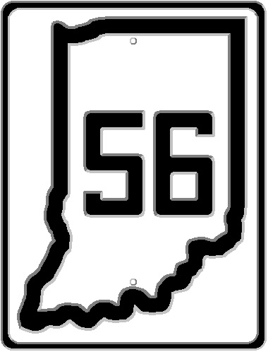
Today’s Road Trip would eventually be across the entire state of Indiana. However, when the Great Renumbering happened, the road connected Princeton to Paoli, and Scottsburg to Lawrenceburg. The rest of the route would be finally added by 30 September 1929, with the Mt. Carmel to Princeton section being the last to become part of the state highway system.
State Road 56 – Cross-state road from Mt. Carmel, Ill., to Lawrenceburg, Ind., by way of Princeton, Fransisca, Oakland City, Moren, Winslow, Cato, Jasper, Haysville, Crystal, Hillham, French Lick, West Baden, Paoli, Salem, Little York, Scottsburg, Blocher, Kent, Madison, Brooksburg, Lamb, Vevay, Mt. Sterling, Rising Sun and Aurora. (The Mt. Carmel (Ill.) – Princeton and the Paoli-Scottsburg sections are new additions to the state system. The remainder of the route is now known as State Road 40.)
After the first decade or so of Indianapolis’ existence, street names throughout the city, and the county, were a hodge podge of miscellanious names. From 1894 to 1899, many street names in the city were changed to give a more cohesive plan to Indianapolis. I have covered some of these: Changes of Indianapolis Street Names in 1895; Indianapolis: State Named Streets; and Why Do Indianapolis Street Numbers Start at 9? But that wasn’t the end of the street name changes in Indianapolis…and especially throughout Marion County. Today, I want to look at some of the old names that went by the wayside.
In 1918, rumored to be due to anti-German sentiment in the Indianapolis area, two street names had been changed. First, Bismarck Avenue became Pershing Street. Second, Germania Avenue became Belleview Place. This was two years after Schurman Avenue became henceforth known as Harding Street from what was Speedway Avenue (nee Lafayette Road/Crawfordsville Road, now Waterway Boulevard) north to 30th Street.
16th Street, at one point, had been known as Tinker Street. Audubon Road was the new name given, in 1903, to College Avenue in Irvington when that town was annexed by the city. 1916 also saw Fairgrounds Avenue changed to Fairfield. Bosart was the new name given to what was Mozart Street.
In June 1939, a series of street name changes occurred that would add some names to the city, while moving some around. 48th Street from the Monon to Keystone Avenue became 49th Street. 49th Street from Arsenal to Baltimore became 51st Street. Hunter Street, from Morris to Woodlawn, became St. Patrick Street.
Two streets without names were given names that were continuations of the streets they connected to: both 29th Street and 30th Street from Riverside to the White River bridge were given those names, even though to that point they had no official designation other than “unnamed public way.” The street that connected Limestone Street to the Michigan Street bridge over White River went from “unnamed street” to Michigan Street. And Michigan Street was changed to Michriver Street.
White River Parkway, East Drive, was the new name given to an unnamed street east of White River from Michigan Street to 10th Street, and from (the now named) 30th Street to 38th Street. Another parkway, this time Pleasant Run North Drive, took over the old Gale Street from English Avenue north to Avon Street, Avon Street from Gale to Front Street, and an unnamed street from Front Street to Sherman Drive. On the opposite side of the Pleasant Run, Lake Avenue from English Avenue to Sherman Drive became Pleasant Run Parkway South Drive.
An unnamed street from Fall Creek south to 16th Street would become Aquaduct Street. Mitchell Street would take over the first unnamed street from 10th to 11th west of Centennial. The first alley north of Palmer, from Meridian to Charles Streets, was renamed Heart Street, in reference to Sacred Heart Church. Oliver Avenue was continued from its end at White River Parkway West Drive to Kentucky Avenue. Northern Avenue became Caroline Street, and Jackson Street became Adams Street, from 34th to 38th.
Moving out to Marion County as a whole, quite a few of the old county roads were given names to better fit Indianapolis. Isenhour Road from Eagle Creek east to Michigan Road became 62nd Street. Poplar Grove Road and The Sheets Road became 86th Street. The Sheets Road was across Washington Township, from the Pike-Washington township line through the village of Sterling (at the Springhill and Williams Road) to the village of Nora at the Westfield Road. The road through Sterling was changed to Spring Mill Road, and Westfield Road was changed to Westfield Boulevard.
What is now Moller Road from 52nd Street north to 62nd Street was called Zionsville Road, and Zionsville Road from 62nd Street to 96th Street was called Pike Township Road. The old Platt-Whitehead Road became Ditch Road north of Westlane Road, and Grandview Drive south of the same. 21st Street outside the city limits of Indianapolis had been Shearer Pike. German Church Road, before being named after the interurban stop at the National Road (Washington Street) was known by both Franke Road (changed, apparently, due to confusion with Franklin Road) and Bade Road. Muessing Street and Muessing Road through Cumberland were also called Cumberland Road (the name it still has above 10th Street).
There were other names given to roads that weren’t because they were a straight line, but because they were the responsibility of a particular toll road company before Marion County took them over. For instance, Southport Road connected Antrim, at Mann Road, to what is now Sherman Drive, then turned south along Sherman to County Line Road. What is now Southport Road from what is now Emerson Avenue to Arlington Avenue, and Arlington Avenue from Southport Road to County Line Road was called Bunker Hill Road. Frye Road was the original name for Stop 11 Road. Center Church Road and Stop 8 Road were both names for what is now Edgewood Avenue (which, strangely, is 1/2 mile south of what was the town of Edgewood, which was on Norwood Road [now Epler Avenue]).
There are so many more that I could cover, but I feel like I have rambled on enough. Feel free to share, in the comments below, some that you know of.
One of the biggest misconceptions about the time of World War II in the United States is that most everything pretty much stopped for the duration of the war. While this is mostly correct, due to shortages of materials for all items available, the state of Indiana still had to maintain its state highway system. The number of projects would be brought way down. But there were still needs. Especially when it came to projects that would, seemingly, help the war effort at home. The beauty of the whole thing is that even during the war, Indiana still had laws requiring publication of contracts for bidding. Hence, the newspapers of the state had listings of the projects to come.
All of the following projects were being bid by the Indiana State Highway Commission. They were published in May, June and August of 1942. The construction work would continue into 1943, and some bids were taken into 1944 for some of these projects.
Allen County: 5.625 miles on State Road (US) 24, from New Haven northeast. Concrete pavement and resurface.
Carroll County: Bridge on State Road 75. Structure 75-J-3486, 65 foot plain concrete arch over Middlefork Creek, 1.7 miles north of State Road 26.
Clark County: .692 mile on State Road 62, Sleeper Lanes between Watson and Charlestown. Concrete pavement.
Clarke County (sic): .637 mile on Dutch Lane Road entrance U. S. Quartermaster Depot at Jeffersonville. Bituminous stabilized widening and bituminous surface treatment.
Daviess and Greene Counties: 2.809 miles on State Road 45, from 1.8 miles south to 1 mile north of the Daviess-Greene County Line. Bituminous retread surface or concrete pavement.
Greene County: 4.122 miles on State Road 45 from 3/4 mile west of Scotland to 1/2 mile east of Doans. Bituminous retread surface or concrete pavement.
Green County: 4.673 miles on State Road 45 from 0.5 mile east of Doans to original State Road 45. Bituminous retread surface of concrete pavement.
Hancock and Henry Counties: 5.971 miles on State Road (US) 40 from Cleveland to Knightstown. Concrete pavement.
Jackson County: Bridge on State Road 250. Structure 250-F-3489, re-erect 75 foot St. Truss bridge with untreated timber floor over Hough Creek, .4 miles southeast of Brownstown.
Johnson County: .516 mile, east entrance to Camp Atterbury from U. S. 31 near Edinburg (sic). Concrete pavement.
Kosciusko County: Bridge on State Road 13. Structure 13-M-1864, reinforced concrete slab over Turkey Creek in Syracuse.
Lagrange County: Bridge on State Road 120. Structure 120-J-3090, Treated timber over Pigeon River – one at 18 feet, eight at 20 feet, and one at 18 feet – 2.7 miles west of Howe.
Lake County: 1.933 miles on Riley Road and Canal Street in East Chicago, Indiana. Concrete pavement and resurface.
Marion County: 1.003 miles, 16th Street from Emerson to Arlington Avenues at Indianapolis. Concrete pavement.
Martin and Daviess Counties: 4.643 miles on State Road 45 from 1.7 miles south to 3 miles north of C. M. St. P. & P. R. R. (Milwaukee Road) west of Burns City. Bituminous retread surface or concrete pavement.
Martin and Daviess Counties: 1.786 miles from proposed State Road 45 to U. S. Naval Depot Area. Bituminous retread surface or concrete pavement.
Porter County: 3.267 miles on State Road (US) 20 from 3.2 miles west to .1 mile east of N.Y.C. Railroad underpass at Porter. Concrete pavement and resurface.
Porter County: 2.802 miles on State Road 20 (US 20) from .1 mile east of N.Y.C. Railroad underpass at Porter to .6 mile east of State Road 49. Concrete pavement and resurface.
Porter and LaPorte Counties: Bridges on State Road (US) 30. Structure 30-D-540A, treated timber over Hutton Ditch, 5.3 miles wast of Valparaiso. Structure 30-E-600A, treated timber over Slocomb Ditch in Wanatah.
Pulaski County: 5.841 miles on State Road 39, from State Road 14 north 6 miles. Compacted aggregate surface.
Vanderburgh County: 1.230 miles on Twelfth Avenue, Broadway and St. Joseph Avenue in Evansville. Concrete pavement.
Today, we go back to looking at the history of automobile manufacturing in Indiana. Today, we start in New Albany, working our way through Muncie, Peru, and Elkhart. Before it comes up, I DO plan on covering Studebaker…I promise. One can not simply ignore the longest Indiana owned auto maker when covering such a topic. I am deciding whether to cover the company as a separate entry, or as a part of this series.
American Automobile Manufacturing Company – New Albany (1908 – 1913): This company really wasn’t based in Indiana…but it was manufactured in the state. The company started in 1908, when the American Automobile Manufacturing Company started by acquiring the Jonz Automobile Company of Beatrice, Nebraska. The offices were moved to Louisville, Kentucky, in 1910, with the factory built on six acres along Vincennes Street in New Albany. The factory had been that of the New Albany Woolen Mill Company. By February 1912, a receiver had been appointed for the company on the application of Chester C. Jones, patentee of the gasoline engine made by the company. The financial trouble was reported as lack of working capital. The bankrupt company was purchased by Ferdinand N. Kahler, a New Albany businessman. Kahler had been making wooden body and frame components for cars since 1908. In December 1912, the company became the Ohio Falls Motor Company…but that was dissolved in July 1913. It was reincorporated as the Falls City Motor Company. The Kahler Company, which basically owned the motor car company continued after the 1914 final bankruptcy and liquidation of the Falls City Motor Company. All assets were sold to the Crown Motor Company (later Hercules Motor Car), and Kahler continued to manufacture parts for other companies, including making frames, floor boards battery boxes and other components for Henry Ford’s Model T.
Bryan Steam Motors – Peru [1918 – 1923]: This company, founded by former Santa Fe Railroad engineer George A. Bryan, generally made what were called light steam tractors. The plan of the company was to start making cars, of which they had built roughly half a dozen. The company had actually always been named the Bryan Harvester Company. The company still exists to this day, building steam boilers for building use as Bryan Boilers in Peru.
Crow-Elkhart Motor Company – Elkhart [1909 – 1923]: This company was founded by Martin E. Crow. The company produced 16 models of cars in their 14 year history, with one being rebadged by the Black Motor Company of Chicago as the “Black Crow.” One of the features that Crow-Elkhart had in their cars was the popular seating arrangement at the time: Cloverleaf seating. This was described as “staggered seats, with the driver’s usually ahead of the others.” This gave way to “rumble seats,” of bench seats, in the 1920s. Color choices available from Crow-Elkhart were: napier green; live green; black; fern green; white; cherry red; battleship gray; rover gray; cobalt blue; and cream. The logo consisted of a heart shaped insignia with a antlered elk’s head in the center. The company filed for bankruptcy in 1922, and was sold for $78,000 in 1923.
Elkhart Carriage and Motor Car Company – Elkhart [1905 – 1931]: Originally started as the Elkhart Carriage and Harness Company, the owners of the company decided in 1905, some 30 years after the company’s founding, to start producing automobiles. The first product, the Sterling, was offered from 1905 to 1909. Later expansion of the company’s offerings created a niche market that Elcar, the new name of the concern, filled very well – taxi cabs. By 1931, competition from Henry Ford and the brothers Dodge, led to the demise of Elcar. The last car to be manufactured at their Elkhart factory was the Mercer, a car for another manufacturer. There were only two of these built before the company gave up entirely.
Sheridan – Muncie [1920 – 1921]: I included this one simply because it was based and built in Muncie. The Sheridan was the first automotive company that was created by William Durant’s General Motors from the ground up. To that point, all other car companies that were a part of General Motors was purchased and folded into the company (Chevrolet, Oakland, Oldsmobile, Buick and Cadillac). But things weren’t going to go well for the new company. Durant was fired by GM before Sheridan could really get off the ground. He bought the nameplate and factory from GM. The Sheridan nameplate, endorsed by Eddie Rickenbacker, was destined for great things. As it turned out, by the summer of 1921, Sheridan started sliding into oblivion. The company had been renamed Durant Motors, and the Sheridan name, despite a backlog of orders, went by the wayside. The Sheridan nameplate disappeared completely by September 1921.
Another short state road, when the Great Renumbering occurred.
The official State Highway Commission description that was published in newspapers in the days before the Great Renumbering was as follows: “Crown Point to Gary. (Now part of State Road 8.)”
Original State Road 8 encompassed parts of what became SR 53 and SR 55. Part of the new SR 55 would be changed to SR 53 later.
A topic that has always interested me, but I have never covered in either the ITH Facebook group, or here on the blog, are some of the strange things that one can find listed in city ordinances when it comes to “rules of the road.” Some things are “universal.” A stop sign means stop…usually. A red light means stop…again, usually. Crossing gates being lowered at a railroad crossing means a train is coming. But there are some things that are set by the city to give more specific instructions to those that travel city streets. Today, I want to look at Indianapolis. To be honest, the reason I picked Indianapolis is because it was the first one that I ever looked up way back when…exactly, I couldn’t tell you. But Indianapolis has had their ordinances online for a very long time.
The one that always caused me to laugh is weight limits on streets and bridges. Section 441-364 is the part of the city’s ordinances that lists “vehicles on certain streets restricted.” Most of these have been in place for many, many years. Paragraph (e) states “no motor vehicle of the following designated gross weights, with load, shall use the following enumerated streets, except such portions thereof as may be state highways.”
To show how long some of the streets in the list have been on that list, I only need to point out that there is a weight limit of 10,000 pounds gross weight on 17th Street from Belleview Place to Lafayette Road (U.S. Highway 52). And that is how it is written in the city code. Lafayette Road hasn’t been US 52 since I-465 was completed to Brookville Road on the east side of the city.
Two other streets that are included in the weight limit list, and have been, again, for a long time, are Meridian Street from 16th Street to 86th Street and Madison Avenue from Pleasant Run Parkway to Southern Avenue. Remember when I mention paragraph (e) a couple of paragraphs ago? The Madison Avenue mention caught my attention pretty quickly when I saw it the first time. Well, technically, that section of Madison Avenue, a six lane divided highway, stopped being a state highway on 1 July 1999. As did the Meridian Street section. So I guess if the city REALLY wanted to make money…errr…enforce its ordinances, Madison Avenue can really help the cause. What makes it worse is that trucks, using the expressway section just north of Pleasant Run Parkway, have no place to go without violating the ordinance. Pleasant Run Parkway has the weight restrictions. Even if you COULD turn a truck onto that narrow road. At the south end, turning on Southern Avenue is something I wouldn’t want to try in a truck. Oh, no.
Another restriction that makes me chuckle when I read it is the weight restrictions on 16th Street. The 10,000 pound gross weight limit on 16th Street applies to that section from Arlington Avenue to the east city limits. Since most of these rules were coded in the 1970’s, the city limits were, technically, as they are today…the county line. A quick look at a map of Indianapolis will show that the county line is past the end of 16th Street…by two miles. Some are just short restrictions. 51st Street can not be used by trucks from Hillside Avenue east for a span of 150 feet. Trucks are also banned from a section of the east side I refer to as “the alphabets.” East from Franklin Road, the streets are named in order, starting with B, up through H. The restrictions, hence, are on Bazil, Cecil, Devon, Eaton, Fenton, Gibson and Harbison, between Washington and 10th Streets. Occasionally, out here near ITH headquarters, a truck will find itself wandering down the survey line road between Washington Street and Brookville Road. That section of German Church Road also has a weight restriction. And only that section.
Most of the streets on the weight limit list actually make sense. Most are residential neighborhood streets that make driving a car on them a test of a driver’s skill. I wouldn’t want to contemplate how someone would put a large truck on those. Of course, these limits don’t apply if there is a local delivery necessary.
Another thing listed in the city ordinances is speed limits. As a general rule, Indianapolis has a 30 miles per hour for residential streets. This is subject to change depending on alterations listed in Section 441-323. To give an idea of how the speed limits were changed at different times, let’s take a look at East 10th Street. The speed limit along 10th Street is 35 miles per hour from Sherman Drive to Cumberland Road. But it is actually listed in the city code in three places: Sherman Drive to Mitthoefer Road; Mitthoefer Road to German Church Road; and German Church Road to Cumberland Road. The highest speed limit mentioned in this section of the Municipal Code is on 38th Street from Cold Spring Road to the west junction of I-65. The city has set that speed limit at 55 miles per hour. The lowest, with quite a few entries, is 20 miles per hour.
Other things listed in the Municipal Code are: Section 441-336 – Left turns prohibited at enumerated locations (this includes no left turns at all times, and no left turns at certain times); Section 441-337 – Restriction on left turns in the central traffic district; Section 441-338 – Required right turn; and Section 441-339 – Authority of board of public works to prohibit right turns on red at certain locations. All of the one way streets in the city are listed in Section 441-342. Four streets are listed in Section 441-344 because these streets have middle lanes that designated reversible travel. And East Street on that list is for one block…from Sanders Street to Orange Street.
All of the information used in this post comes from the Indianapolis – Marion County Code of Ordinances, Chapter 441. It is available online at https://library.municode.com/in/indianapolis_-_marion_county/codes/code_of_ordinances?nodeId=TITIIPUORSA_CH441TR. There are a lot more things in that chapter than I covered here. If you really are interested to know what the City of Indianapolis regulates when it comes to traffic, I recommend checking out that link.