West Marion County and I-465

This image has an empty alt attribute; its file name is images.jpg

The first part of the new beltway (almost) around Indianapolis started on the westside of Marion County. As mentioned in other articles, the original plan was to start Interstate 465 at Interstate 65 on the northwest side, with the replacement for State Road 100 (which I-465 officially was) heading south from there to circle around the county from there. Interchanges were planned at I-65, I-74/US 136, 10th Street, US 36 (Rockville Road), US 40 (Washington Street), Weir Cook Municipal Airport (Airport Expressway), Interstate 70, and SR 67 (Kentucky Avenue). According to USGS topo maps, like that included below, show that there was a stub ramp connecting I-465 to 62nd Street, although the ramp connecting to 62nd Street was listed as still proposed six years later.

1962 USGS topographic map showing the original interchange connection Interstate 65 and Interstate 465.

Construction started along the corridor in 1959. The Indianapolis News ran a series of pictures showing the plans set out by the State Highway Department. If you noticed the list of interchanges above, there were no plans for 56th Street or 38th Street to have ways to access 465. Bridges were to be built over 465 at 56th, 46th, 38th, 34th, and 21st Streets. (21st Street was a very special, and contentious, situation. I covered it in the article: “Building I-465 at West 21st Street. [8 May 2020]”)

Indianapolis News, 14 December 1959, showing the Indiana State Highway Department’s plans for the new Interstate 465 (also still called State Road 100 at the time) at the northern terminus of the highway.

The plans for Interstate 65 at that point were to continue to have it replace US 52 (Lafayette Road). The US 52 bypass at Lebanon was made part of the new I-65. The temporary plan was to connect I-65 just southeast of I-465 directly to US 52 until construction could continue. Then I-65 would also be US 52 from that point to northwest of Lebanon. I mention this only because the loop around Indianapolis was, apparently, easier to get approved than trying to run I-65 through town. (And since it would take another 16 years to complete, even to the point that an addition was planned to I-465 and completed before I-65 through Marion County says it all.)

It wouldn’t take long after the original plans for the interstate were laid down that changes were made. The non-planned 38th Street interchange was added to the deal. It was to be a partial cloverleaf interchange connecting to 38th Street at that point. Marion County had decided to build 38th Street from Lafayette Road east to the new White River bridge to be built by the city. At that point in history, 38th Street was a county road with nothing resembling the connections it has today as a major west side thoroughfare.

Indianapolis News, 11 December 1959, showing the future connection to 38th Street from I-465. This ramp would be built much later, when 38th Street was finally connected as a thoroughfare across Marion County.

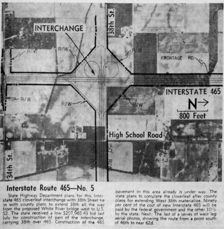
The next interchange south of the “gonna be built someday” 38th Street was the connection to another interstate highway, Interstate 74. The plans shown in the Indianapolis News differ slightly from what was actually built. US 136 (Crawfordsville Road) is directly connected to the east end of the proposed interstate connection. This would change. It looks like the proposed interchange was moved slightly north, and Crawfordsville Road west of High School Road was turned north to connect to High School Road. This would be where US 136 would ultimately officially end.

Indianapolis News, 10 December 1959, showing the proposed connection between interstates 74 and 465. The original plan, and this was carried out, is that Interstate 74 would “travel over,” ISHD/INDOT term for multiplex, with I-465 from northwest to southeast Marion County.
1953 Topo map showing the intersection of West 10th Street and High School Road.

The next section did change, at least at one interchange, quite a bit. But before I describe that, let’s talk about the placement of I-465 from Vermont Street north to about where 16th Street would be, if it continued to High School/Girls School Road. The new interstate was planned, in that section, to be built directly over High School Road. This is not really a stretch, since High School Road, from Washington Street south to the Airport, was the original State Road 100. And I-465 was, for all intents and purposes, State Road 100 according to ISHD.

I have written a detailed history of SR 100 (SR 100: How did it come to be? [9 March 2019]) and an article about how, at one point, the connection between SR 100 on BOTH sides of Marion County were to have cloverleaf interchanges (“The Cloverleaf Interchanges at US 40 and SR 100” [20 November 2019]). If SR 100 had been completed on the west side, like it was on the north and east sides, I have no doubt that it would have followed High School Road north, probably, ultimately, to 86th Street, which was SR 100 along the northwest side.

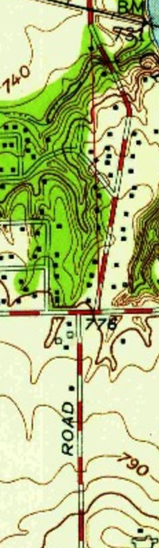
The change in interchanges happened at 10th Street. The original plan was for a full cloverleaf interchange at that intersection. This would have pushed the eastbound 10th Street to southbound 465 ramp back closer to Glen Arm Road, where High School Road was rerouted to miss the interchange. What was ultimately built was a jumbled three-quarter cloverleaf with a flyover from westbound 10th to southbound 465.

In the end, High School Road was basically built over by 465 from Vermont to 10th Streets. 10th Street is a survey correction line, so High School actually moves slightly to the east at that point, as shown in the topo map to the left. For more information about survey lines, check out “Survey Lines and County Roads. (29 March 2019)”

Indianapolis News, 9 December 1959, showing the Indiana State Highway Department plans for I-465 from just south of the New York Central railroad tracks to just north of the Baltimore & Ohio Railroad tracks, including what was to originally be full cloverleaf interchanges at 10th Street and Rockville Road.
1953 USGS topo map of the area of Washington Street and High School Road. The area marked “Ben Davis” would be the location of the new cloverleaf interchange between US 40 and I-465.

From the looks of aerial photos in 1959 as shown in the Indianapolis News, the interchange at Washington Street was going to be very destructive. (Keep in mind that as of the writing of this article, MapIndy, my go to source for historic aerial photos of Marion County no longer offers that service. Maps are available, but the aerial photos are gone.) In addition to the shunting of Morris Street (a survey line and historic route of its own accord), most of where the interchange between US 40 and I-465 was basically what had been the town of Ben Davis.

Another thing would have to happen before this interchange would be built. It was determined, and reported, in July 1959 that an improvement of West Washington Street would have to occur before the interstate reached that point. US 40 was to be widened in the area. The work on Washington Street, however, would have to wait until sewer work in the area was completed…probably in 1961. Plans to widen Washington Street from 40 feet to 68 feet wide, with a four foot median and an eight parking lane on each side, were decided upon. Very little of that plan exists today…and if it does, it’s hard to find.

Indianapolis News, 8 December 1959, showing the proposed area of US 40 and Interstate 465.

The last area covered by the Indianapolis News in the series of articles (actually, it was the first since the editor staff decided to post them south to north, even though the interstate was built north to south!) shows the area of I-465 near Weir Cook Municipal Airport. The one change that I can see is what would become Airport Expressway (check out “Indianapolis’ Raymond Street Expressway” [4 February 2020] for the history of what started out as the Bradbury Expressway) was proposed to connect to the airport heading slightly north of due west, just above Southern Avenue. This section of the (now) Sam Jones Expressway is due east-west at the point it connects to Interstate 465. For a history of what is now Indianapolis International Airport, check out “Indianapolis Municipal Airport.” (20 August 2019)

Indianapolis News, 7 December 1959. This newspaper snippet shows the area of proposed I-465 near the (then) Weir Cook Municipal Airport (now Indianapolis International).

That covers the first of the construction of the State Road 100 replacement. I want to share this one last snippet from the Indianapolis News of 19 October 1960. It shows the construction of I-465/I-65/US 52 at 62nd Street…or the original northern end of Interstate 465.

Indianapolis News, 19 October 1960, showing the original northern end of Interstate 465.
Advertisement

Subway Street, Beech Grove

When the Big Four Railway started to build their new yards in what would become the city of Beech Grove, they realized very quickly that train traffic was going to be, at best, horrifying for those that were trying to get to the town from the north and east. The main road from the north was the line separating Center from Warren, and Perry from Franklin townships. This would be called First Avenue in the new town of Beech Grove, and Emerson Avenue in the rest of Marion County.

1905 Map of the Beech Grove area, before construction of the town. Center of the map is where the four townships (Center, Franklin, Perry and Warren) meet, now the intersection of Emerson and Albany Street (Troy Avenue).

This road, before Beech Grove was built, stretched from a point in Washington Township, near Millersville, to the Johnson-Marion County line east of Greenwood. Part of this was considered to be part of the Churchman Free Gravel Road extension when the Big Four started buying the property. What became Albany Street (Troy Avenue in the rest of Marion County) extended from the Bottoms Road (now Harding Street) to what is now Kitley Road near the Hancock-Marion County line.

With the construction of the new railroad shops, and the new town, at Beech Grove, the railroad knew that it wouldn’t be long before it came up that two major roads in the county were being clogged by rail traffic. The elevation movement had already been in full swing in Marion County, although there were no such facilities completed to that point. Arguments were still being had about who was supposed to pay for all the bridges necessary to accomplish the plan. It was here that the planners decided to make sure that both carriage (and later car) traffic was unimpeded by the mass amounts of train traffic.

Emerson Avenue would be cut off just north of the Big Four railroad tracks north of the new town. This would put the cutoff just shy of 1/2 mile north of Albany, or 1/2 mile south of what would become Raymond Street. A new street would be built just north of the northern right-of-way of the railroad tracks, where it would connect 1/2mile east of Emerson, becoming the continuation of Troy Avenue. About 2/10’s of a mile east of Emerson, a new road would be built at a 90 degree angle to the railroad tracks, going under said railroad tracks, connecting to the new Second Avenue and the street running along the southern railroad right-of-way (to become Bethel Avenue) in Beech Grove.

1956 MapIndy aerial photograph of the Subway Street/Connection Street/Emerson Avenue/Bethel Avenue area near Beech Grove. west of the spur tracks leading into the Beech Grove Shops is a stub end of Emerson Avenue starting at Subway Street. It would connect to essentially a long driveway and a house west of Emerson and south of the railroad tracks.

The first street mentioned would be given the name “Connection Street.” The road that would go under the railroad tracks would be called “Subway Street.” The name subway actually has a historical context in Marion County. When traffic at Indianapolis Union Station got beyond horrible, the city of Indianapolis decided to build an underpass along Illinois Street, under the railroad tracks at the station. This was, for years, called the Illinois Street Subway, although it was more a bridge, even a tunnel, than a subway.

This wasn’t to say that Emerson Avenue disappeared completely between the two sides of the railroad tracks. A small section of Emerson Avenue existed from Subway Street north to a road, and house, 1/4 mile north of Albany Street. It existed this way for years. Until the early 1970’s, as a matter of fact.

Indianapolis Star, 15 April 1971. The photograph shows a four lane bridge in the middle of nowhere, over the tracks of what was, at the time, the Penn Central Railroad at Beech Grove. That bridge would be connected to the surrounding area, and would carry Emerson Avenue into Beech Grove from the north.

The new Emerson Avenue bridge over the Penn Central tracks, as they were called then, was completed in Spring 1971, although the connections to the new bridge weren’t complete. The road that connected to the house in the 1956 photo above would become the new Subway Street, which was turned to intersect and cross Emerson Avenue north of the old connection point.

1956 MapIndy aerial photograph with a 2020 overlay of then current conditions. This shows the driveway and the house, that would be removed when Subway Street was relocated with the building of the Emerson Avenue bridge north of Beech Grove.

The new ending of Subway Street would be at Fifth Avenue, instead of Second. Sections of the old Subway Street, from the new turn to Second Avenue, still exist to this day, almost 50 years later. And looking at the Google Map, or even MapIndy, will show that the property lines of the old Subway Street are still valid.

The railroad that created the town of Beech Grove is long gone. The Big Four became part of the New York Central, officially in 1930. The New York Central gave way, in 1968, to the Penn Central, which found the NYC merging with its long time rival the Pennsylvania. Soon after the creation of the National Passenger Rail Corporation, called Amtrak, there was a move to have Amtrak purchase the Beech Grove shops from Penn Central. This would happen in 1975.

A quick glance at the MapIndy property records leads to some confusing things, however. The property that the Amtrak shops is on does actually belong to the National Passenger Rail Corp. But it has to cross property that is still legally owned by the Penn Central Transportation Company. Now, I realize that the tangled web of property ownership and changing railroads can cause such things. But the property right next to it is owned by New York Central Lines LLC c/o CSX Transportation. As does most of the property north of the Amtrak Shops and south of the railroad mainline. The property records lead to a lot of fun reading. There are four different railroad companies legally listed as owners in that area: National Passenger Rail Corp.; CSX Transportation; New York Central Lines LLC (CSX); and Penn Central Corp (c/o C E Parker General Tax Agent Penn Central Trans Co, Chicago, Illinois). What’s strange is that all the property owned by the Penn Central is exempt from property tax.

Indianapolis: Indiana Avenue Bridge Over Fall Creek

Early in the history of town of Indianapolis, when the state started building roads to connect the fledgling capitol to the rest of the state, a road was built from the northwest corner of the original Mile Square, traveling northwest. That road would be called both the Lafayette Road and the Crawfordsville Road, since it went to both. After the road crossed Fall Creek one mile north of the center of the town, it took a route closer to White River. That section would later be called Speedway Avenue and Waterway Boulevard. But the bridge over Fall Creek, connecting the two sections, would take nearly two decades for a true resolution. And it required the removing of several streets, including the historic Lafayette/Crawfordsville Road.

1937 MapIndy Aerial photograph of the Indiana Avenue & 10th Street area.

The bridge is question is shown on the above 1937 MapIndy photo. At that time, the intersection at the bridge was a confusing jumble of streets running in different directions. At what became the intersection of 10th Street and Indiana Avenue, there were also connections to Locke Street (heading south past the City (Wishard) Hospital, and Torbett Street running north of 10th heading east. Many people still referred to 10th Street between this intersection and the White River Parkway as Fall Creek Parkway…but that was its old name by the time this photo was taken.

Indiana Avenue had become a major route for people leaving downtown Indianapolis for the northwest suburbs. The northern end of both of Indiana and Speedway Avenues were connected to 16th Street, which ran west from Indiana Avenue to the Emrichsville Bridge over White River. The state had connected separate sections of 16th Street from Indiana Avenue east to Northwestern Avenue as part of State Road 34. Traffic, therefore, was heavy across the bridge.

That was until the summer of 1936.

It was then that the city of Indianapolis limited the bridge traffic to five tons. Trucks and busses found themselves having to go around the closed bridge by using 10th and 16th Streets. In the fall of 1938, the bridge was closed completely to all traffic. Street cars found themselves now being rerouted around the snarl. Indiana and Speedway Avenues north of Fall Creek simply became cul-du-sacs because they had no southern end at all.

The Indianapolis News of 7 May 1943, in an editorial piece, mentions that in 1936, when trucks were banned from the bridge, the Board of Works announced a $110,000 plan to build a new bridge on the site. “In the fall of 1938, the bridge was closed to traffic and a year later the city was promising solemnly to produce a new one almost immediately.”

That was followed in the fall of 1940 by the City Council and the City Engineer coming together to talk about building a new bridge for Indiana Avenue. The City Engineer was “ordered to determine ‘by the next meeting’ the precise status of the matter.” That went nowhere as it was in 1941 that a discussion was held about finding an old bridge from somewhere else to replace the old Indiana Avenue bridge that had, at that point, been completely closed to traffic for three years.

As mentioned above, the editorial was run in the News in May 1943. The bridge was still closed to traffic.

A week later, on 12 May 1943, the Indianapolis News ran another editorial on the same subject. “Mayor Tyndall expresses in one short sentence what many have had in the back of their minds for years about the Indiana avenue bridge over Fall creek. ‘If the army had to cross it, the bridge would be fixed over night,’ he declared. The bridge has stood year after year, closed to all but pedestrian traffic, while tens of thousands of motorists and others have been forced to detour by way of West and Sixteenth streets to get to the baseball grounds and parts of the city northwest of there.”

The News goes on to mention that many times over the past four and a half years, attempts have been made to remedy the situation. Without result. Some of the blame was placed on pending flood control and prevention improvements to Fall Creek. Those improvements still hadn’t happened. The News was advocating for a solution to the bridge issue sooner than later.

And action was taken when Mayor Robert H. Tyndall cut the ribbon on 1 November 1944 to open the newly repaired Indiana Avenue bridge over Fall Creek. Traffic could begin moving across the facility again. Trolley traffic on the Riverside line would start again on 27 November 1944. And everything was great. For almost six years.

The headline in the Indianapolis News of 24 March 1950 read “Indiana Avenue Bridge Out for Baseball Fans.” Simply, it meant that the old bridge over Fall Creek was closed to traffic again. The sticking point, again, came down to whether to spend $35,000 to patch the bridge, or wait until the flood control improvements made it a requirement to replace the bridge. The flood control project, which was estimated to be around $1,000,000, was still in the works as it had been since the early 1940’s.

As it turned out, less than a month later, the city council voted to appropriate $120,000 to fix the old bridge. This was required before bidding could begin on the the contract to fix it. It would seem that it would take longer than expected. It became a political issue when, in October 1951, just prior to the Marion County elections, the political party in charge was blasted for not taking care of a bridge that not only served baseball fans and residents of the northwestern section of the city, but served as an emergency route to Wishard Hospital, which sat just south of the bridge.

The Indianapolis Star said it best in the first paragraph of a story with the headline “City To Spend $120,000 For New Bridge” on 9 April 1952. That first paragraph read “the city is going to sink $120,000 into a new bridge which may be torn down within three years.” While Mayor Clark of Indianapolis was telling the City Engineer to rebuild the bridge, he was also telling the engineer to continue looking into getting Federal money to move Fall Creek 100 feet to the north as part of the flooding control and prevention program.

The flood control issue would finally be resolved in 1959. On 9 August 1960, the old Indiana Avenue bridge was closed once again, this time for good. The bridge was immediately closed and dismantled. It would be replaced by a four lane facility. The flood control project would also require the creek to actually move 100 feet to the north of its then current position, a rerouting of Speedway Avenue, to be renamed Waterway Boulevard, to a new connection with Stadium (Indiana) Avenue two blocks northwest of its historic location, and a removal of Locke Street and Fall Creek Parkway East Drive for the intersection at 10th and Indiana. (The old Torbett Street had long before been cut off from the intersection, becoming a driveway for the old YMCA that stood on the northeast corner of Fall Creek Parkway and 10th Street.)

17 July 1961, Indianapolis News

The new channel for Fall Creek and the new Indiana Avenue bridge was completed in July 1961, as shown in the above photograph from the Indianapolis News of 17 July 1961. The bridge would be opened to traffic as soon as reconstruction of the intersection at the southern foot of the bridge was completed on 1 August 1961. The below MapIndy aerial photograph from 1962 shows the reconfiguration of the intersection, the new location of Speedway Avenue, and the removal of the ends of Locke Street and Fall Creek Parkway East Drive.

1962 MapIndy aerial photo of the area around the Indiana Avenue bridge over Fall Creek.

I-65 and I-465 On The Northwest Side – A Pictorial History

Today, I want to use MapIndy and USGS Topographic maps to show the progression of the interchange between I-65 and I-465 on the northwest side of Marion, just east of Eagle Creek Park. I am going to have four aerial photos in this entry: 1941, 1956, 1962 and 1972. Also, small snippets of several topo maps are used. Strangely, the 1941 and 1956 are almost identical.

1941 MapIndy aerial photo of the area around the I-65/I-465 interchange on the northwest side of Marion County.
1956 MapIndy aerial photo of the area around the I-65/I-465 interchange on the northwest side of Marion County.
1961 USGS Topographic Map of the interchange between I-65, I-465, and future SR 100, now known as I-465.

The 1961 USGS Topo map shows the pending SR 100 connection. Bridges appear in the 1962 aerial, especially Lafayette Road over I-465. It should also be noted that on the USGS maps, the pending I-465 was also marked SR 100. Also, what is now I-65 fed directly into Lafayette Road at this point. This made sense, since I-65 was the replacement, between Indianapolis and Labanon, of US 52…which followed Lafayette Road in this area.

The next photo is from 1962. The missing section in the picture had not changed much, if at all, from the 1956. The Dandy Trail did not cross Eagle Creek at a right angle to the creek. It had been replaced by a bridge on 56th Street. And the reservoir still hasn’t been built. Both interstates, I-65 going straight through the area, and I-465 veering off to the south, catch the eastern edge of the park like area west of Lafayette Road north of 62nd Street. That park like area is listed on the 1953 USGS topographic map as “Eagle Creek Forest.”

1953 USGS Topographic Map of Eagle Creek Forest.

It should be noted that 62nd Street was completely orphaned west of the interstate when it was built. Reed Road, which at the time before the building of the reservoir and the park ended at 62nd Street, was the access to the orphaned section west of the interstate.

The state had already made plans to make the complete I-465 loop, including between 56th Street north to the north leg. However, it never did get federal approval. If it was going to be built, the state would have to build it not as the interstate, but as a state road. Hence it was decided that the road that I-465 was replacing, SR 100, would be the designation for that section.

1962 MapIndy aerial photo of the area around the I-65/I-465 interchange on the northwest side of Marion County.

The topo map of 1967 (1969 edition) shows the completion of Eagle Creek Reservoir and Park. It shows the area that had been the Dandy Trail Bridge over Eagle Creek. I have included two snippets of that map. The first is the I-465/I-65 interchange, with the proposed SR 100 connection. The Second shows the 56th Street causeway over the reservoir.

1969 USGS Topographic Map of the I-65/I-465/Proposed SR 100 interchange.
1969 USGS Topographic Map of the 56th Street Causeway over Eagle Creek Reservoir.

By the time that the 1972 photo was taken, the Eagle Creek Reservoir and Park was in place. Reed Road, which allowed access to the park area with the circular road, was still in place, but as I recall it had been closed to traffic on the 56th Street end. The Dandy Trail bridge had been replaced with the 56th Street Causeway, mainly because the old road was under water at that point.

The major change, relating to the subject at hand, was the completion and connection of the section of I-465 north of I-65 heading off towards the north leg of the bypass route. That section was built not as part of I-465, but as SR 100. It wouldn’t stay SR 100 long, as the Feds allowed it to become I-465…as long as the state continued to pay 50% of the building cost as opposed to the normal 10%. So, yes, that section of I-465 was a state choice…the Feds approved it after construction was started. This would cut even more of 62nd Street, and High School Road, out of the city landscape. The curve, connecting Lafayette Road to 62nd Street heading east, had already cut the corner of 62nd Street and High School Road off from connecting with anything other than Lafayette Road to the west.

1972 MapIndy aerial photo of the area around the I-65/I-465 interchange on the northwest side of Marion County.

It hasn’t change much in that area since 1972. There are some rumblings of changing the interchange to make it more friendly to interstate-to-interstate transfer. But nothing has come of it.

I-465 and I-70, Marion County East Side, A Pictorial History

Today, I want to take a look at the interchange between Interstates 70 and 465 on the east side of Marion County…in pictorial form. This history will cover from 1962 to 1993, with what aerial photographs are available from MapIndy, the official mapping application of Indianapolis/Marion County. It will also cover the interchange between Interstate 70 and Shadeland Avenue, which was SR 100 before, and for some time after, the building of its replacement, I-465.

1962
1972
1978
1979
1986
1993

Two of the constrictions at the location of this interchange were both 21st Street and Franklin Road. Franklin Road had been in place since it was created as the Noblesville-Franklin State Road early in the state’s history. As you can tell from the photos, the routing of Franklin Road was changed between 21st Street and around 25th Street. The original routing of the road is still in place, but contains two dead end sections at the interstate.

21st Street has been around for a whole lot of years, as well. Maps show that it was added to the county sometime between 1870 and 1889. In 1889, there was a toll house for the Pleasant Run Pike on the northwest corner of 21st Street and Shadeland Avenue. From what I can tell, the only part of the road that was a toll road was from Arlington Avenue to Mitthoeffer Road. Today, 21st Street can be followed from Massachusetts Avenue at the Bee Line (Big Four – Conrail – CSX) Railroad to a point just northwest of Charlottesville.

The ramp from I-70 West to I-465 South was under construction in 1978, and would be completed in 1979. Prior to this, that traffic movement was handled by a loop ramp, as the interchange was originally built as a 3/4 cloverleaf. By 1993, the current collector/distributor system connecting Shadeland Avenue to both I-70 and I-465 was completed.

The ramps to Shadeland Avenue have always been a very tight fit into the area allowed.

Indianapolis and Requested Changes to the Interstates

The construction of the interstates in and around Indianapolis were always contentious. Whether it be a direct route to the northeast side, or the routing of Interstate 65 from downtown, controversy was never a stranger to the entire process. Things were desired, things were shot down. Today, I want to focus on some requests from the Metropolitan Plan Commission to the State Highway Commission when it came to the designs of both I-465 on the east side and I-65 on the south side. These requests were publicized in July 1968.

The reason that the Metropolitan Plan Commission ever was involved in the first place was a then new Federal regulation designating the group as the review agency for the entire region. The MPC was given review powers over any project that used Federal funds in any way.

The first project that they wanted to change involved I-465 from 56th Street to White River. The major recommendation for this project is that land be acquired between the interstate and Shadeland Avenue, then SR 100, for landscaping between the two. The MPC also made the request that SR 100 between Fort Benjamin Harrison and Castleton be widened, eventually.

Two other recommendations for I-465 were purchase of more right of way in the area of Allisonville Road and 82nd Street, and the removal of the planned 75th Street bridge. The first would allow improvements to the intersection of Allisonville and 82nd…something that is always needed, especially after improvements are made. The second would have eliminated any crossing of the interstate between 82nd Street, which at the time was SR 100, and 71st Street.

The major recommendations were made to the south side on Interstate 65, however. Those recommendations would lead to a very different scenario for those traveling I-65 between Thompson Road and Whiteland Road.

The first recommendation involved Stop 8 Road, now called Edgewood Avenue. The original plan involved Stop 8 Road crossing over the interstate, as it does to this day. The MPC recommended that plan be scrapped, and a full interchange be put in at Stop 8 Road. The building of the current overpass at Edgewood required the demolition of two homes, and the building of an access road to several others. As shown in the 1962 MapIndy aerial photograph below, it would have required much more ROW acquisition.

The second recommendation was to change the planned interchange at Southport Road to just a grade separation. That’s right. The busy intersection of Southport Road and Emerson Avenue would have not involved an interstate interchange as it does today. I am unsure why such a recommendation would have been made. Below is an aerial picture of the area in 1962.

Next, the Metropolitan Plan Commission recommended a change to the width of the Stop 11 bridge clearance, making it wider. This would allow a wider roadway under Stop 11 Road. They also recommended that it be considered for conversion to a full interchange at a later point.

The last two recommendations would allow for a wider roadway for the interstate, and room for expansion later. The two bridges that would be involved were the Emerson Avenue bridge and the County Line Road bridge. The ROW under these two structures, it was recommended, should be wider.

In the end, most of the recommendations involving interchanges were shot down in the end. Southport Road became the access point to I-65. You could still cross the interstates at Edgewood Avenue, Stop 11 Road, and 75th Street. The bridges at Emerson and County Line were made wider and higher for future expansion.

1917: Main Roads to Fort Benjamin Harrison Need Work

When Fort Benjamin Harrison was built in Lawrence Township, in northeastern Marion County, getting there was quite the chore. It has been built along the Big Four’s Bellefontaine, or Bee, line. This allowed steam locomotives to pass by the new Army post on a regular basis. The Big Four, with its affiliation with the New York Central, could get Army traffic to and from the fort to almost any place in the United States without much effort.

The workforce for the new fort would come on either the Bee line, or the new Indiana Union Traction line that connected Indianapolis to Anderson, Muncie and Fort Wayne. Although it didn’t last much more than three decades, this was an important way to access the fort. The station for that interurban line still exists…and is open to the public as a Mexican restaurant (as of this writing) called the Hacienda.

But automobile traffic was becoming more and more important. Even more important was the transit of Army vehicles to and from Fort Benjamin Harrison. To that end, in the spring of 1917, the commander of the station, General Edwin F. Glenn, sought to get improvements to the road system to the fort. With this in mind, he held a conference with Marion County government and business leaders to share what he had in mind.

The Indianapolis Star, 10 June 1917. Map of the north east side of Marion County, showing improvements needed to access Fort Benjamin Harrison.

First and foremost in the General’s mind was the main road to the fort – the Pendleton Pike. Technically, the Pendleton Pike started at the limits of the City of Indianapolis at Bee Line connection to the Indianapolis Belt Railway just east of Brightwood Avenue (Sherman Drive). West of that point, it was called Massachusetts Avenue. The county had taken over the Pendleton Toll Road in the late 1880s. But little was done for its improvement or maintenance. By the time the Army created the fort, the road was little more than a connection to other roads in rural Marion County and downtown Indianapolis. Many battles were fought about the improvement of the road, lasting past the end of World War I, when such improvements were vital.

The Pendleton Pike, in 1917, was being improved…slowly but surely. The plan was to concrete the road from the Indianapolis City Limits to 38th Street, just west of what is now Shadeland Avenue. From there, the first of the two sections to the fort’s main north-south entrance, would be improved with heavy stone. This would take the heavy stone from 38th Street to the old Noblesville-Franklin State Road, or Franklin Road. The next section would be graveled. This section ran from Franklin Road to the Yerger or Acre Free Gravel Road, now known as Post Road. The section of the Post Road, connecting Pendleton Pike to the interior of Fort Benjamin Harrison, was being hard surfaced with a “special preparation,” according to the Indianapolis Star of 10 June 1917.

The next road to get attention was the “54th Street Road,” connecting west from the fort to Millersville. Those of you from the area might be a little confused. The village of Millersville was along the Fall Creek, just inside the Washington Township border at what is now Emerson Way. The main drag from Fort Benjamin Harrison is now called 56th Street, not 54th. That road was built along the half-survey line starting where the Millersville and Fall Creek Free Gravel Roads come together near what is now Emerson Way at Millersville Road. The highlighted section of the following MapIndy photo, from 1952, shows the original route connecting the Millersville Road to the old Fall Creek & Mud Creek Road. (At the time, what is now Rucker Road continued south of what is now Fall Creek Road. It would be that way until sometime before 1962, when two lakes were built. The Rucker Road extension would finally be taken out sometime between 1979 and 1986.)

The Millersville Road, according to the Indianapolis Star “is by no means a direct route to the fort. It begins at Thirty-eighth street and Fall Creek and meanders northeast about eight miles to the famous Baker’s bridge and thence southeast a quarter of a mile to the fort grounds.” Baker’s Bridge is along the old Noblesville-Franklin State Road, now called Boy Scout Road, in the northwest corner of the Fort Benjamin Harrison grounds. General Glenn wanted the entirety of the Millersville Road covered with gravel…a job that, according to the General, with five wagons in two days. The first three miles of the Millersville Road had already been improved with asphalt. The next half mile being oiled gravel. The rest of the road was gravel…and work was being done at the time to repair damage done by large, heavy, loads transiting the road.

Other roads being worked on for access to the fort were the National Road from Irvington to Acre Road, Emerson Avenue, Arlington Avenue, 34th Street and the Acre Road itself.

At the time, National Road was the actual name of the Washington Street extension outside the limits of the City of Indianapolis at Sheridan Avenue in Irvington. West of Sheridan, it was Washington. East of that point, it was the National Road. The first mile of the National Road, from Sheridan Avenue, was being concreted. That would end near what is now Shortridge Road and Washington Street. The next two miles from Shortridge Road east were already concreted at that time. That would take it to a point east of Acre (Post) Road. The Acre Road, as of 10 June 1917, was closed for construction of a stone road stretching five miles north to the Pendleton Pike and into the fort.

Emerson and Arlington Avenues were also under construction at the time. Both were being concreted from Washington Street (both are west of Sheridan Avenue) to the Pendleton Pike. Emerson Avenue met Pendleton Pike at roughly 30th Street. Emerson Avenue, at least the southern section of said, ended at the Bee Line. Neither 30th Street nor Emerson Avenue crossed the railroad tracks, and passage past those tracks was done at an underpass on 32nd Street.

Arlington Avenue meets Pendleton Pike (now Massachusetts Avenue) at 34th Street. Improvements along 34th Street included asphalt paving from the Lake Erie & Western (Nickel Plate) Railroad crossing for three miles to the east to what was the northern section of Emerson Avenue. From there to Arlington Avenue, 34th Street was a stone road. Prior to being called 34th Street, the road was the Fall Creek & Warren Township Free Gravel Road.

It would take some time until the roads were improved for to the General’s liking. With the creation of the Indiana State Highway Commission in 1917, the National Road was taken over as Main Market Road #3. It wouldn’t be until 1923 that the Pendleton Pike would find itself part of the state highway system, entering that system as Original State Road 37. By then, the war was over, and traffic to Fort Benjamin Harrison had, while not stopping completely, had slowed considerably as it normally does after the completion of a war. The fort would, eventually, get its connections to the road system other than SR 67/US 36 (Pendleton Pike). In 1941, 56th Street west out of the fort would become part of SR 534, a designation it would only hold for a few years before that state road was routed straight down Shadeland Avenue. With the building of the Interstate system, which was technically built for the defense of the United States, Fort Benjamin Harrison would find itself with two exits from I-465 (Pendleton Pike and 56th Street) and one on I-70 (Post Road). I suppose the Post Road exit on I-74 could technically be listed as part of that…but it is quite a distance from the Fort.

I-465 Construction, the PRR and Madison Avenue

Indianapolis served as a railroad capital for many years before the coming of the automobile. Since surface roads connected Indianapolis to many points in the state in many directions, it was logical that the coming of the automobile would lead to a concentration of automobile routes. But those were still subject to the locations of railroads. The interstate would change all that.

The purpose of the interstate was to create a high speed, limited interruption traffic flow. This, by definition, would require the new interstates to deal with going over or under those rail routes. Most of those intersections were accomplished with the interstate going over the railroads. And these overpasses are high, due to the clearances that were going to be required by the railroads at the time.

If one looks at a map of Interstate 465, one would notice that there is only one railroad bridge over the interstate. That bridge is the original Madison & Indianapolis, then Pennsylvania Railroad, on the southside. The reason for this really came down to the location of the interstate more than anything else.

When the interstate’s location was decided, it would follow closely to the original chosen location to SR 100 which it was replacing. That original location, in terms of Indianapolis modern street names, was Shadeland Avenue, 82nd/86th Street, High School Road, and Thompson Road. A quick glance at a map shows this.

On the southside, through the south central part of the county, this led to the interstate route traversing through the Lick Creek “valley.” The Pennsylvania Railroad already had a bridge over Lick Creek in the area. That same bridge also crossed the road leading into what was Longacre Park (being turned into a trailer park from September 1963), which had been in that location since 1926.

Louisville & Indiana (former Madison & Indianapolis/Panhandle/Pennsylvania Railroad) bridge over Lick Creek and Lick Creek Parkway into Longacre Mobile Home Park. This Google Maps image was sampled on 10 May 2020, from an image captured in June 2019. This image shows both the original bridge and the 1964 concrete expansion places on top to raise the level of the railroad.

The level of the railroad over that section of the coming interstate was right around 13 feet above ground level. This amount of clearance wasn’t enough for the State Highway Commission. This would require the Pennsylvania Railroad to raise the level of the railroad about three feet. This can be seen by the concrete extension over and above the old stone bridge over Lick Creek and Lick Creek Parkway just south of the interstate.

Google Map aerial photo of the Louisville & Indiana crossing of Interstate 465. Image was sampled 10 May 2020.

The Indianapolis Star of 27 March 1964, in a news story announcing road closures throughout the area, mentions that “Lawrence Street will be blocked for two weeks while the Pennsylvania Railroad elevated and repairs the tracks in connection with Interstate 465 construction.”

Also at work at the time was the Madison Avenue crossing of Interstate 465. Before the coming of the interstate, Madison Avenue had been a two lane state road, SR 431, south of Shelby Street. The main access to Longacre Park was actually north of Lick Creek, as shown in the following 1952 aerial photograph from MapIndy. The trailer park along Madison Avenue at Redfern Drive would come into direct play when I-465 started construction through the area.

1957 MapIndy aerial photograph of the Lick Creek area from Madison Avenue to Longacre Park.

Before the interstate construction would reach the area, a redesign of the Madison Avenue crossing of the area was already in process. The new bridge across the future interstate and Lick Creek would be two lanes in each direction. To accommodate this construction, a new, temporary, Madison Avenue would have to be built to bypass the area of the new bridge. Also, utility lines would also have to moved to the east.

1962 MapIndy aerial image of the area of Madison Avenue and Lick Creek.

The image to the left is the 1962 aerial photograph of the area from MapIndy. It shows the bypass Madison Avenue being built through the mobile home park at Redfern Drive mentioned above. The bypass would start south of the current Lick Creek Parkway, and reconnect to Madison Avenue right at the angled intersection of Shelby Street. The bypass route can be seen as the brighter road through the left center of the photo. (It hadn’t seen traffic yet, and as such was brand new concrete.)

Some people have wondered why Madison Avenue is the only (former) State Road that did not have an interchange with Interstate 465. Spacing is the only answer I could come up with. The Pennsylvania Railroad is one-quarter mile, or so, east of Madison Avenue. East Street, the US 31 bypass built in the early 1940’s, is one half mile west of Madison Avenue…not counting the ramp lengths. Shelby Street is one half mile east of East Street through its entire length through Marion County.

1962 MapIndy closeup aerial photo of the Madison Avenue bridge construction over future I-465 and Lick Creek.

The bypass Madison Avenue built in 1962 would become the frontage road in what was later the Madison Mobile Home Park. It is now called McConnell Way. A quick glance at utility lines through the area show that they weren’t been moved back to the side of Madison Avenue after construction was completed. The following aerial photograph, from 1972, shows the construction through the area completed.

1972 MapIndy aerial photograph of Madison Avenue and (then) Penn Central crossing of I-465 and Lick Creek.

For those interested, the cover photo for this post is the same area shown in all the other photos as would have been seen in 1937. That image is also from MapIndy. MapIndy is available online at: http://maps.indy.gov/MapIndy/index.html.

Westfield Boulevard Bridge Over White River

Indianapolis News photo, 2 October 1974

1891. A steel bridge was built to cross the White River north of Broad Ripple on what was then called the Indianapolis & Westfield Free Gravel Road. As was typical of the time, the bridge crossed the White River at a 90 degree angle, making for the approaches, especially the southern approach, were a little tight. The bridge would be used until the city of Indianapolis would have to tear it down in 1977.

The bridge built in 1891 was a replacement for a bridge that had served for many years at the location. The road had been originally built as the Westfield State Road in the 1830’s. Later, in the late 1840’s, the road would be sold to a toll road company for maintenance and to become a turnpike. This would last until the late 1880’s, when it was purchased back by Marion County for the free use of travelers. It would still be the Free Gravel Road when the new bridge was built.

The original road would cross the river as shown in the 1972 aerial photograph above. The sudden right turn approaching the bridge from the south would later create a bottle neck that the State wanted to take care of…or just bypass altogether.

In the mid-1910’s, the old Westfield State Road would acquire a new name: the Range Line Road, an Auto-Trail that would connect Indianapolis to Kokomo and Peru through Westfield. The Range Line Road gained its name because it followed the survey line that separated Range 3 East and Range 4 East in the survey that divided Indiana into one mile square sections.

Another name was given to the road in 1917 – Main Market Road 1. This was the predecessor to State Road 1, which this became in 1919. This brought the Westfield Road, and its two lane bridge over White River into the state highway system. But it wouldn’t be long until the Indiana State Highway Commission discovered the errors in the naming of this route as a major State Road. While in Indianapolis, and up to what is now 86th Street (later SR 534/100), the road was winding and narrow.

Part of being part of the state highway system is that state roads are, with very few exceptions, automatically truck routes. And running trucks through Broad Ripple, even today, could best be described as “fun,” at least sarcastically. The old state road followed Westfield Boulevard from Meridian Street until it turned north in Broad Ripple…making the turn at Winthrop Avenue and the Monon Railroad tracks interesting. It also gets tight while hugging the White River.

The state would bypass this section of US 31 by building a new road straight north along the Meridian Street corridor. This caused a lot of protesting from the people of Carmel, fearing that their main drag, Range Line Road, would be left to rot, and travelers would be guided around the town. While US 31 bypassed this section, it would be given a replacement state road number: SR 431.

Meanwhile, the White River bridge lumbered on. By 1931, SR 431 was now using the facility. It would stay that way until the building of I-465…which would cause the state to move SR 431 from Westfield Boulevard to Keystone Avenue. The state’s maintenance of the White River bridge would end in 1968.

It didn’t take long for the bridge to fall into disrepair. By 1974, it was recommended to the city that the road and bridge be closed completely to traffic. If not immediately, at most within the next two years. The city would lower the weight limit to five tons in 1974. But this did not solve the pending problems with the bridge. In addition, around the 7300 block of Westfield, was another bridge over what is known as the “overflow channel,” a small White River cutoff north of the main channel of the river. The bridge over the overflow channel was in as bad or worse shape than the truss bridge in the 6700 block of Westfield.

1972 MapIndy aerial photograph of the Westfield Boulevard bridge over the White River Overflow Channel in the 7300 block of Westfield Boulevard.

The main bridge would be closed in 1977 for the building of a replacement of the facility. Business owners of Broad Ripple, as early as 1974, had been arguing for either fixing or replacing the bridge in place. Their discussions concerned the fact that straightening the road would allow for high speed traffic to come in through “Broad Ripple’s back door.” Keeping the tight and winding approaches to the White River bridge would slow traffic down before entering the neighborhood. Both ideas were continuously shot down by the city of Indianapolis, the owners of the facility. The City went so far as to recommending that Westfield Boulevard be closed between Broad Ripple Avenue and 75th Street, thus removing the need to replace the bridge altogether.

As it turned out, the bridge would be replaced. Or, more to the point, bypassed. The next photo, a 1978 aerial taken from MapIndy, shows the new bridge and the old bridge it replaced. The old bridge would be completely removed from aerial photos the following year.

1978 MapIndy aerial photograph showing the replacement Westfield Boulevard bridge over White River, and the location of the old bridge.

The new bridge would open on 12 June 1978. But the road wouldn’t. In an example of just fantastic government planning, the Overflow Channel bridge would be closed in either August or September of 1978 for replacement. This would cause the new bridge to be used for only local traffic until the following year, 1979, when the new overflow channel bridge would be completed.

1993 aerial MapIndy photograph showing the Westfield Boulevard bridge over the White River Overflow Channel (7300 block of Westfield Boulevard). Also shown is the abandoned Monon Railroad, prior to the creation of the Monon Trail.

With the opening of the Overflow Channel bridge, Westfield Boulevard was opened again for traffic from Broad Ripple to Nora…and hence north to the downtowns of Carmel and Westfield. While reaching downtown Westfield using the old road has become more difficult with the redesign of US 31 through Hamilton County, it still can be followed on maps – and for the most part in cars, as well.

Bicycling the Lafayette Road

Bicycle Routes as published on 02 May 1896 in the Indianapolis News. (image courtesy of newspapers.com)

The Indianapolis News, in its bicycling routes series, on 02 May 1896, covered leaving Indianapolis via the Crawfordsville Pike and the Reveal/Centennial Pike. This would bring the “wheelman” of the day through what is now Speedway out to and along the Eagle Creek valley to the town of Trader’s Point. That town was, before the building of the Eagle Creek Reservoir, was located at the crossing of Big Eagle Creek by the White River and Big Eagle Creek Pike, which was built as the Indianapolis-Lafayette State Road. Today, that name has been shortened to Lafayette Road.

After turning southeast along the road out of Trader’s Point, the road crosses the Big Eagle Creek then climbs a “stiff hill.” “After climbing this hill the road is undulating for some distance until the valley of the Big Eagle is left far behind.” Before leaving the hilly area, one half mile from Trader’s Point, is a “pump at the roadside all by itself. The water is very good.” One mile from “the Point” is a dirt road that crosses the Pike west to east. That dirt road, to the east, turns into the New Augusta Free Gravel Road, connecting to the town of that name, the Michigan Road and ending at the Spring Mill and Williams Creek Free Gravel Road.

Two miles from Trader’s Point “is a grocery store and blacksmith shop, where one dirt road turns north and another runs east and west. There is a little settlement at this cross-roads and a pretty white church with a green pump in the church yard.” The road to the north is now Shanghai Road. The east-west road, running from a road on the east side of Big Eagle Creek to the Michigan Road, first became Isenhour Road. That would be changed to 62nd Street with the renumbering of Marion County. There are no remnants of that “little settlement,” as the construction of Interstate 65 wiped out the intersection of 62nd Street and Lafayette Road.

From the settlement southeast, Lafayette Road is “much more level.” The first two roads encountered are the Kissell Road (became High School Road, now gone with the same I-65 construction) that heads south and the Centennial Road (running from the Reveal Road to the Michigan Road at Crooked Creek, now known as 56th Street). One half mile later, the Zionsville and Pike Township Free Gravel Road leaves heading north. That road is now Moller Road from north of 52nd Street to 62nd Street. When it was built, it was part of the Zionsville Pike.

Just southeast of the Zionsville Road junction is a post office town called Snacks. Here there is a white church, store, blacksmith shop, brick schoolhouse, and several houses. Next, the bicyclist would encounter the Russe Road, also known as the Reveal and Russe Free Gravel Road. The east end of this road is at the Lafayette Pike. The west end of this road is at the Crawfordsville Road, at a point one mile east of Clermont. The end at Lafayette Road is now known as 46th Street.

South of what is now 46th Street the Lafayette Pike jogs a little to the due south then more east than southeast, and back to the original line of the road. Those turns are shown in the 1941 aerial photograph to the left. (Image courtesy of MapIndy, a service of the City of Indianapolis.) The News mentioned, also, that the Little Eagle Creek comes very close to, and even parallels, the Lafayette Pike at this point.

The article reports that the road gets into better condition as it gets closer to the city. The next Post Office town encountered is Flackville, located at what is now Tibbs Avenue and Lafayette Road. Before that point, two schoolhouses, one with a green pump in the yard, and two uninviting dirt roads. Those roads, the first heading east, is now 38th Street, and the second heading west in now 34th Street.

At Flackville, several roads are encountered. The Guion Gravel Road turns north towards its end at New Augusta. The Flack Road, now 30th Street, crosses west to east. From here, the rider can follow the Flack Road east to the Michigan Road and back to the city. Continuing along the Lafayette Pike, what is now Tibbs Avenue crosses the road north to south. South of Pike is the Marion County Poor Farm.

Before reaching the Crawfordsville Pike at Emrichsville (now 16th Street), the Lafayette Road encounters the Cooper Avenue Free Gravel Road (now Kessler Boulevard) and the Meyers Free Gravel Road (now Cold Spring Road). The Meyers Road connects to the town of Brooklyn Heights and the Michigan Road near Mount Pleasant (Alliance Post Office).

At Emrichsville, the historic Lafayette and Crawfordsville Roads combine for the trip back to the center of Indianapolis. Both roads crossed the Emrichsville Bridge and followed what is now Waterway Boulevard (see The Lafayette State Road In Downtown Indianapolis). Historically, the Crawfordsville and Lafayette Roads both began at the Michigan Road.

The complete trip, as listed in this article was measured at 32 miles. This included the round trip that went out the Crawfordsville Pike, north along the Reveal and Centennial Roads, and back the Lafayette Road.