A Quick Look At Today’s State Roads, From A Historical View

A Facebook direct message from a reader of the blog started the research bug going again. Now, while I am still looking up information on his particular subject (transportation to Center Valley in Hendricks County, particularly a possible railroad there), part of his subject did come up. As well as a few others. Today, I want to look at the things that I have found while researching that topic…while not finding much about the topic.

The “town” of Center Valley is along the route that would become State Road 39 just north of the Morgan-Hendricks line. A post office existed there from 1855 to 1902. But what is important is the route that rumbles north to south through the town…the aforementioned SR 39. It wouldn’t be until 1932 when that section of SR 39 was added to the state highway system. But, the designation “state road” goes back quite a bit…like 1833.

The 17th General Assembly of Indiana passed into law several state roads. The first I want to mention would be the one that would make Center Valley (or, more to the point Centre Valley) a place. The route that would eventually become SR 39 was built as the Martinsville-Danville-Frankfort State Road. The southern end would be part of the state highway system from 1920 – the bridge over White River west of Martinsville. The northern end would be part of original State Road 6, connecting Lebanon to Frankfort. As original SR 6, it would become SR 39 with the Great Renumbering.

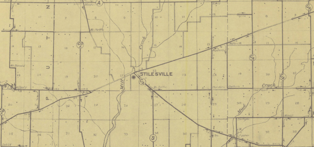
Two more state roads would from Martinsville would be added to Indiana with this meeting of the General Assembly. The first is one that would not become part of the state highway system. It was described as “an act to locate a state road from Martinsville, in the county of Morgan, by the way of Cox’s mill and Solomon Dunagan’s, in said Morgan county, to Stilesville, in the county of Hendricks.” This is an example of how the General Assembly would set up a “state road” through a particular person’s land. I would assume that what is now Tudor Road, southeast of Stilesville, was part of this road.

Another state road project including Martinsville did make it to the state highway system… eventually. The act created “a state road from Martinsville, in Morgan County, to intersect the state road leading from Madison to Indianapolis, at Edinburgh, in Johnson county by the way of Morgantown in said Morgan county.” This state road would be added back into the state highway system in the 1930’s…as State Road 252. A history of that road is available from ITH here.

But Martinsville wasn’t the only beneficiary of that particular meeting of the General Assembly.

A state road was created by the General Assembly to connect the town of Lagrange, in Tippecanoe County, to Logansport, in Cass County. Where is LaGrange? Well, it was a town along the Wabash River at the Warren-Tippecanoe County line. It was founded by Isaac Shelby in 1827…and had a post office from 1832 to 1835. It’s prime was with the Wabash Canal during the riverboat era. When the Wabash Railroad was built on the opposite side of the Wabash River, the town of LaGrange just dried up and disappeared.

Another road that was created at that time would connect Williamsport to the Illinois-Indiana State line via Lebanon (sic), now West Lebanon, and the now abandoned town of Chesapeake (about two miles east of Marshfield). This route will require some research.

Part of the road that would become, in time, SR 46 between Newbern and Bloomington would be added as a state road in 1833. The original road would start at the Michigan Road in Napoleon, travel through Camden (unknown today), Newbern, and Columbus to Bloomington. The section from Newbern to Columbus was part of the state highway system as SR 46, until INDOT truncated SR 9, turning the old SR 9 into SR 46.

Stilesville would be mentioned again as a state road was created to connect it to Crawfordsville via New Maysville.

The last road for this article would be a road that is still in existence, more or less, but not part of the modern state highway system. The description of the act was “to locate a state road from Green Castle, in Putnam county, to Carlisle, in Sullivan county, by way of Manhattan in Putnam county and Bowlingreen and New Brunswick, in Clay county.” Some day, I want to do more research on this road.

1910: The National Road West of Indianapolis

Today, I want to show some map snippets of the National Road, and its replacement sections, as of 1910. Now, there is a small problem with this. The maps that I am going to use here are from the United States Postal Service from 1910. And while they are available from the Indiana State Library online, there are two that are noticeably absent from the collection: Clay and Marion Counties.

Marion County is easy to deal with. There are so many historic maps of Marion County available on the web that if I really wanted to, I could get something to cover the area. Clay County is an entirely different story. That is going to take some work.

Many people, today, are used to the straight ribbon of asphalt and concrete that is US 40 through Indiana. But that wasn’t the case when the road was created in the 1830’s. As was the standard operating procedure at the time, roads were built as straight as they could be. There was no heavy machinery to move a hill, or flatten a valley, in the early to mid 1800’s. Surveyors were extremely important at that time, to get the best road possible. If it could come in using less materials, and more importantly, less money, so be it. Most bridges across streams along the way crossed at a right angle to the stream. This was to make the bridge both safer and less expensive.

The hilly terrain of the area southwest of Indianapolis made the National Road surveyors a bit of hassle, as well. Hence, the relatively straight road that we know today was a lot of work and bending the old road into shape…and out of existence. The following maps show the road as it was in 1910. I wanted to give a comparison map from USGS maps…but the earliest available at this time is 1941, meaning that the road has already been replaced in most areas. And looking at Google Maps, there are very few sections that still exist of the original road that was replaced. But, I hope that these maps will start your own research into the original federal highway.

1910 USPS Map of Rural Delivery Routes in Vigo County west of the Wabash River.
1910 USPS Map of Rural Delivery Routes in Eastern Vigo County.
1910 USPS Map of Rural Delivery Routes in Western Putnam County.
1910 USPS Map of Rural Delivery Routes in Eastern Putnam County.

The map above shows the Reelsville bypass of the original National Road. I covered it in the article “National Road at Reelsville.”

1910 USPS Map of Rural Delivery Routes in Western Hendricks County.
1910 USPS Map of Rural Delivery Routes in Eastern Hendricks County.

US 41 in Gibson County

Princeton, IN-IL, 1:62,500 quad,
1903, USGS

While looking through old USGS topo maps, I found one that caught my interest almost immediately. I have talked over the past year or so about how the current state roads came to be as old county roads from early in Indiana’s history. One that shows this very well is what would become SR 10 in 1919 and US 41 in 1926.

The map to the left shows the county roads between Fort Branch and Hazelton in 1903. Yes, 1903. This is the USGS map, 1903 Edition of the Princeton, Indiana, 1:62500 scale. I have used Microsoft Paint to draw lines of two colors on it. The green lines show where US 41 is today, using the roads as they were in the turn of the 20th century. The blue lines show roads that would be, through history, part of US 41 before it was bypassed. The area in Princeton is harder to nail down, so I included two routes through the town. Both are possible, and since at the time of this map there was no US 41, it didn’t matter which way travelers went.

Historical Topographic Map
Collection, 1942, USGS

As is typical of the USGS, no new maps were truly drawn after 1903 at this scale…at least none that are accessible. What is shown to the right is the 1903 map updated to 1942. It shows several changes in the routing of US 41 between its creation in 1926 and 1942.

First, starting at the top, is the Hazelton Bridge. Construction started in 1921 to replace a ferry near that location. The bridge, as mentioned in the link above to another Indiana Transportation History article, carried SR 10 (and the Dixie Bee Highway, as it was known at the time) over the White River near Hazelton. The bridge was massive. Said to be one of the largest ever built (to that time) by a state highway department in the midwest.

Another section that would be moved before 1942 would be south of Patoka. The road that is now Old US 41 between Princeton and Patoka is actually a replacement. During the 1930’s and 1940’s, the Indiana State Highway Commission made it a point to shorten and straighten state highways. A lot of this put the new location of the state highway next to a section of railroad tracks.

If you have any doubt about this building technique, check out SR 67 southwest of Indianapolis (Kentucky Avenue – moved 1936), SR 67 northeast of Indianapolis (Pendleton Pike, or actually, its replacement), SR 44 from Shelbyville to Rushville (railroad tracks were in place until 1980 or so), and SR 135/252 from Trafalgar to Morgantown (road was built around 1940-1941, tracks were abandoned at very near the same time, although some remnants of those tracks still remain 80 years later).

US 41 would run beside the Chicago & Eastern Illinois tracks between Princeton and Patoka, entering Princeton north of the old route by about two blocks. South of Princeton, the old route was followed toward Fort Branch.

Historical Topographic Map Collection, 1962, USGS

By 1962, several changes were made again to US 41. From Patoka to Hazelton, the route was moved to its current location, replacing the old Hazleton bridge and widening and straightening the road most of the way. There was one section of road that was still two lanes according to the USGS maps of 1962…and that was being rectified.

The old Hazelton Bridge remained in place for years after its replacement by the Indiana State Highway Commission. It would be given to the counties for their maintenance.

At the same time, the current routing of US 41 was also completed. The USGS shows the year of the map as 1961 on the Princeton 7.5 degree quad. (The map to the left is the 1962 update of the 1959 Patoka 7.5 degree quad.)

The major point of this article is to show how the country roads looked in 1910, and before the state started taking over, to give an idea of how one got from point A to point B at that time. These maps, especially those of 1903, really show off the routes that were depended upon early in the history of Indiana. It also shows that, in Indiana, the fastest way between two points is not always a straight line.

County Roads – Getting Named

County road names. Most people don’t give it much thought. A year ago, I wrote an article about the names used around the state for the county roads. Today, I want to look at some of the histories that I have found about the subject.

The subject of naming rural roads was taken up at different times in different parts of the state. Until that point, roads may or may not have had names…but not as some sort of system. Marion County, for instance, had names like Wall Street Pike (West 21st Street from Speedway west) or the name of the resident that paid to have the road maintained. There really was no pattern to any of it.

The Cambridge City Tribune, of 9 August 1900, described the rumblings like this: “In some parts of Indiana a plan is being discussed for having all the county roads named. At the road crossings the names will be placed on posts, something like the old fashioned finger boards. In addition to that each farmer will have his name displayed on a post at the road side at the entrance to his grounds. Something of the kind will be done in all rural districts with the next few years, and it is very much needed. Farmers are beginning to discuss the matter at their meetings.”

St. Joseph County, according to the South Bend Tribune of 2 April 1918, had been working on names for the county roads since the summer of 1917. A plan was accepted and adopted by the St. Joseph County commissioners on 4 March 1918. The current names were placed on the county roads then. In 1934, the South Bend Tribune made sure to point out that rural roads in St. Joseph County were all marked the same way city streets were…with signs hanging high above the road.

The reasons for naming county roads involved things like mail delivery and safety. In the days of the automobile, it made sense to name the roads for travelers to be able to find places. But it started out as an attempt to be able to speed mail delivery. With rural routes all over the state, it was not unheard of that someone’s mail would be delivered to the wrong part of the county. Giving houses numbers, and roads names made mail easier to locate. As for safety, it goes without saying that if the farmer on such and such road had a structure that was on fire, unless the emergency crews where such and such road was, and where the farmer lived, that fire was going to be completely destrucutive.

The most common method of naming county roads in Indiana was called the “Purdue Grid Coordinates.” It is a system where every place in the rural areas of the county are assigned a location based on a central point in the county. This system often involves the north-south middle of the county to be called “Meridian,” and the east-west to be called “Division.” But that is up to the particular county, actually. Some counties do use “00” for the center.

The system was created by researchers for Purdue University’s Joint Highway Research project in the School of Civil Engineering. The plan was to create a system that would allow easier directions for rural areas. For example, the Lafayette Journal and Courier of 9 Jan 1954, used the following example of Doc Smith trying to find Ben Miller’s farm: “take this highway north about five miles, and then instead of turning with the highway at the big pear orchard, continue straight ahead on the County Farm gravel road. It winds a bit, but after about two miles you’ll come to a five-point intersection. Take the road that cuts slightly to the left, follow it to the second crossroad, then turn left. It’s only about a mile from that corner to Wahoo. You’ll have to inquire at the grocery store for Ben’s farm.”

Franklin County, in 1953, was still considering a naming system for the roads of that area. It had been recommended several years earlier, but nothing was ever done.

Hamilton County decided to start looking at their road names in 1958. It started with a report by the Jaycees. That took several years to work on. It was decided that Hamilton County would not use the Purdue grid system, since most people preferred names to numbers. Numbers were assigned from Indianapolis, giving rise to street numbers above 96th to 296th. Each county road, however, that went north and south was given a secondary number to show how far east and west of Indianapolis’ Meridian Street you were. While names were decided upon in the early 1960’s, most addresses weren’t completely determined until the 1990s.

On 10 October 1961 the Rushville Republican printed the following question when it came to county road names: “Is Rush County going to be among the last in the state to get its county roads named and numbered and house numbers for its rural residences? Decatur County is the latest to join the fold. It’s not a costly procedure and it makes it so much easier to locate places in the country. All it takes is a nod, and a bit of cash, from the county commissioners to permit this community to keep up with its neighbors.”

It would be 1962 when all counties in Indiana finally had a system in place, and signs posted. Indiana had passed a law in 1961 requiring all county road intersections to have road name signs posted.

Dandy Trail – Revisited

In the early days of the automobile, the Hoosier Motor Club created a scenic tour of Marion County. That tour, an 88 mile journey through the countryside around Indianapolis, was named the Dandy Trail. When one looks at a map, the only part of Dandy Trail that exists by that name is in the northwestern part of the county. And almost none of it was part of the original scenic tour route.

This particular route has been covered by me before in a post called “Dandy Trail.” Jim Grey, another blogger and co-admin of the Facebook companion to this blog, also covered it with his article “It’s 1921, and you’re taking a pleasure drive on the Dandy Trail.” But today, I want to put the Dandy Trail, and its changes, into a historical context.

Starting off with an overview of the section of the original Dandy Trail from about 65th Street south to its original connection with Crawfordsville Road from back in 1953. Above 56th Street, it wandered through the Eagle Creek valley on the west side of that stream. It crossed the creek at 56th Street, then followed the lay of the land on the east side of Eagle Creek. From 56th Street south, it was also mostly a dirt road…never having been improved over its 30+ years of existence.

The connection to Crawfordsville Road was made at what is now called Salt Lake Road, although, as one can tell by looking at the map, that name was actually applied to what is now 34th Street. The current westerly bend of the road, connecting it to the dotted line in the bottom left corner of the snippet, came later. I will cover that. That dotted red line is County Club Road.

The next snippet shows the next point of interest…crossing Eagle Creek. Now, I have shown this several times, but I have not been able to do so with maps that actually show the lay of the land before the reservoir was built.

The northern end of the interest area shows the town of Traders Point. The following snippet is from 1953, as well. Traders Point was located on the old Lafayette Road, just north of Big Eagle Creek.

Historical Topographic Map Collection

Several changes occurred in the path of the Dandy Trail between 1953 and 1967. First, the building of Eagle Creek reservoir. Second, the building of Interstate 74. And, as show in the following map snippet, the almost complete removal of Dandy Trail between 38th and 46th Streets. Also, the southern end was connected to Country Club Road, as it is today.

And as shown in this map, from 46th Street north to the northern end of this particular quad of USGS topo map, most of the original route was either placed in the flood plain, or in the actual reservoir. One can still see the outline of the old bridge over Eagle Creek near 56th Street in the topographical data. At this time, Dandy Trail didn’t connect between 46th Street and 56th Street.

Historical Topographic Map Collection

The northern end didn’t fair much better. Traders Point, a town prior to the building of the reservoir, was no more. But it wasn’t because it was in the reservoir…it was in the flood plain. I will post a link to that particular map to show exactly how much area the reservoir was expected to cover in case of emergency. This particular map shows the area in 1966. The road that is broken by Interstate 65 in the center of the snippet is the original Dandy Trail. Notice that it skirts the northern bank of the reservoir. It is still there today, although accessibility is questionable.

The last image I want to share is the 1967 topo map that had been updated showing conditions in 1980. The purple marks on this map show the updates. A new map was not made, just modifications to the old one. This shows the new Dandy Trail from 38th Street north to 56th Street.

In 1980, 46th Street became Dandy Trail as it turned north toward Eagle Creek Park. Today, that traffic situation is reversed, as 46th Street turns south to become Dandy Trail. Also, the intersection at 38th Street, which was 38th Street ending at Dandy Trail, has been changed over the years to become 38th Street westbound turning south to become Dandy Trail.

Very little of what is called Dandy Trail today is what was originally given that name. But the name survives…as if there is still a connection to the past. The name Dandy Trail seems strange on the Hoosier landscape. But it remains, even if we have to explain why it’s there.

The link to the Traders Point topo map showing the flood plain of the Eagle Creek Reservoir according to the United States Geological Service is this: https://ngmdb.usgs.gov/ht-bin/tv_browse.pl?id=16e9e185f52a80db3128924a7ab11716

1959 – Interstate Contract Bids

When the interstate system started being built in Indiana in the late 1950’s and early 1960’s, contracts for building those roads started flying fast and furious. The interstate system came into being in 1956…and the first contracts were finally let in 1959. The Indianapolis News of 29 May 1959 reported all of the contracts that were let to that point.

First four miles of Interstate 465: “Low bid for construction of the first 4 miles of Interstate 465, the new belt highway to encircle Indianapolis, has been submitted by an Evanston (Ill.) firm. The construction contract also will include the building of 1 1/3 miles of Interstate 65 – the Indianapolis-to-Chicago expressway – northwest of Indianapolis.”

One of the things that keeps coming up when it comes to the interstates, their designations and their contracts is the actual name for I-465. Legally, that’s what it was, Interstate 465. However, for many years, until the interstate was done, or even beyond, the news media would not only refer to it as Interstate 465, but as the New State Road 100. A lot of people at the time simply saw it as a replacement for SR 100, which it was. This was also brought on by the fact that the original contracts from the state had project numbers for both roads.

This contract covered I-465 from a point north of US 136 to West 62nd Street. It would run west of High School Road through the area. The section of Interstate 65 included in this contract would run “parallel with and west of U.S. 52, from just northwest of West 65th to just southeast of High School Road.” The bid for this contract was $2,257,679.81.

The same company won the $1,705,758.49 bid to construct Interstate 74 from SR 267 in Brownsburg to just east of the Hendricks-Marion County Line. This 4.5 mile section of what the News referred to as the “Indianapolis to central Illinois expressway” would be built north of US 136.

As is typical of the way Indiana bids contracts for road projects, bridges and roads are bid separately. The above contracts did not allow for bridges…just the approaches. Bridges would be bid usually earlier than the road.

The first new Ohio River bridge linking Indiana and Kentucky in 30 years was let on a bid of $994,979.58 to Roy Ryan & Sons of Evansville. “The bridge will be double-decked, with three lanes of one way traffic on one level and three lanes of one way traffic on the other level.”

Three bridges were let on the Interstate 74 project mentioned above. Ruckman & Hansen, Inc., of Fort Wayne, won two of them. $187,129 for the bridge over Big White Lick Creek west of SR 267, and $219,553 for the bridge over SR 267. Carl M. Geupel Construction Company bid $218,712 to build a county road bridge over Interstate 74, 1.2 miles southeast of SR 267.

These were among the first contracts to be let on the new Interstate highway system in Indiana. Many more would come.

National Road Through Richmond

When the National Road was surveyed through Indiana, it had the distinct honor of being one of the straightest roads in the state…another being the Michigan Road. This was on purpose. Most roads through the state were built around whatever was in the way. Very few roads were built for getting from point a to point b in the quickest way possible. That was left to the state to buy the property necessary to do that.

One notable exception is through Richmond.

The area around Richmond started being settled around 1806. By the time the National Road surveyors got there in the early 1830’s, the town had already been established. And in the way of the nearly straight as a board road coming from the Ohio capital of Columbus. So when the road got to Richmond, it made sense to run it straight down Main Street. And that’s what happened.

However, on the west bank of the Whitewater River, upon which Richmond sits, the continuation of the straight line from Ohio would be continued. This would mean that the road would actually start again south of its location through Richmond. One block south, as a matter of fact. This led to the layout of Richmond, and the road, as shown in the following 1840 map snippet.

On this map, it is labeled Cumberland Road.

As you can see, the Cumberland Road is opposite Walnut Street on the west side of the Whitewater River. That would be South A Street today. The name change of the streets would occur sometime before 1893, as shown in the 1893 snippet below.

The National Road bridge over the Whitewater River would be built in the location shown on the first two snippets in 1832. The same bridge served residents of Wayne County and travelers on the National Road for 65 years. News reports across the state were reporting that deconstruction of the bridge would occur in August 1897. (Source: Muncie Evening Press, 13 August 1897) It was reported in the source newspaper that “the work of removing the old National road bridge at Richmond, Ind., will begin next week.”

The slight variations in the location of the bridge between the 1840 and 1893 maps are just that, slight variations and could be attributed to slight errors. A measurement here or there could change the map by a few feet…which looks like the case here. Another map, this time from 1853, shows the same area, more like the 1840 map than the 1893 variety.

The original structure was a very large affair…at least for that time. It was easily as large as the National Road bridge at Indianapolis. The Richmond Palladium-Item of 21 October 1962 did an article on a painter from Centerville that had done two paintings of the old bridge. A picture from the article is below.

Another view drawn of the bridge was published in 1911 in Century Magazine. It would accompany an article about the old bridge written by a Richmond native. That drawing is shown to the left.

In 1916, it was reported in the Cambridge City Tribune of 3 February 1916, that “the total cost of the construction of the temporary bridge across Whitewater at the location of the old National road bridge at Richmond was $4,895, of which the county, city and traction company each pay one-third, or $1,798.” I can find no news story about why a temporary crossing of the river was necessary.

The original route, more or less, of the National Road through Richmond would become Main Market Road 3 in 1917. That designation would be changed to State Road 3 in 1919. The slight difference would be on the west side of the river, where the state road followed First Street, not the river, to travel between Main Street and National Road. By this time, a third bridge over the Whitewater River was serving as the facility to cross that wide gorge. On 1 October 1926, SR 3 would be forever changed to US 40.

1962 USGS Topo map of US 40 through Richmond.

In 1998, INDOT decided to build a new bridge across the river, and reroute the old National Road/US 40 through the city of Richmond. This would put the road on its current path through the city, leaving Main Street out of the mix, at least west of 11th Street, as the major thoroughfare for the first time in almost 200 years. The city of Richmond took over the then abandoned route of US 40, creating a more plaza like environment along the historic street.

The new US 40 bridge that was completed in 2000 was advertised as the fourth bridge to serve as the National Road crossing of the Whitewater. I suppose, in a way, this is true. However, the historic crossing was closer to Main Street, which still has a bridge facility across the wide gorge. Not that I have heard arguments over the issue, it is one that road geeks and historians (or, in my case, both) will probably be discussing for years to come.

Vincennes: The Lincoln Memorial Bridge

Few people in American history hold a place as high as Abraham Lincoln. The Kentucky native that became the 16th President of the United States, also spent time living in Indiana before moving on to Illinois, where he would become famous throughout the nation. It was decided that a bridge, supposedly marking the spot where Lincoln crossed into Illinois, would be built to connect Indiana and Illinois. It became the Lincoln Memorial Bridge.

The George Rogers Clark Memorial was soon to be constructed in Vincennes. As part of that memorial, a celebration on 3 September 1933 to dedicate a new bridge at Vincennes connecting Indiana and Illinois were scheduled. The date chosen for the dedication of the bridge was the 150th anniversary of the signing of the Treaty of Paris, bringing an end to the War for Independence and the creation of the United States of America as a separate country.

The Abraham Lincoln (George Rogers Clark) Memorial Bridge as shown in the Indianapolis News of 28 April 1934.

The bridge, when it was built, would carry US 50 across the Wabash from Vincennes, Indiana, to Lawrence County, Illinois. It would become a major link in that road for several decades. It would be a replacement of a bridge that spanned the Wabash from Main Street in Vincennes for many years.

The high approaches on the Indiana side were due to requirements by the War Department. The Munster, Indiana, Times of 17 July 1931 states that “rigid war department requirements forced the engineers to give the 1,850-foot bridge a clearance of 50 feet above the normal water level on the theory that some time navigation might be resumed in the Wabash.”

At one point, the plan of the city of Vincennes, and Knox County, was to build a boulevard between the George Rogers Clark Memorial and the Wabash River for the rerouting of US 41 along the new route. I am not sure if it was part of the plan, but Culbertson Boulevard runs from Main Street north to Hart Street between the railroad and the river. The US 41 idea never materialized.

In 1936, the bridge, as well as US 50, would be closed for one day. Sunday, 14 June 1936, would see the closing of US 50 in both Indiana and Illinois as the George Rogers Clark Memorial was dedicated at Vincennes. For four and half hours, detours of over 40 miles were in place as festivities were held to celebrate the GRC Historic Park dedication. Chief among those that would be on site would be President Franklin Delano Roosevelt.

The Abraham Lincoln Memorial Bridge still stands today, almost 90 years after the concrete structure was built. Yes, US 50 has been rerouted around Vincennes. The bridge now serves as Indiana State Road 441. And, according to Google Maps, the same road number in Illinois, although on the ground, there are no such markers in place that I have ever seen.

1836-1838: Michigan Road in the Newspaper

Yesterday, I wrote an article about early state roads, and the Michigan Road. Today, I want to look at the Michigan Road…as it was related to the public in newspapers from 1836 to 1838. One of the most interesting things that I have found in this search is the fact that it was entirely possible that the Michigan Road, as we know it, might not have been built. It could have been a railroad route.

Richmond Weekly Paladium, 31 December 1836: Allocation of money involving the Michigan Road was the topic before the General Assembly in December 1836. $140,000 was appropriated “on a turnpike road commencing at Kirk’s on the Michigan road in Clinton county, thence through Frankfort to Delphi and Monticello in White county, and thence by best route to Michigan City.” Another $75,000 are allocated for the Michigan Road between Napoleon and Indianapolis. And yet another $175,000 is appropriated “in contructing a Macadamized road on the line of the Michigan road from Indianapolis to South Bend, thence to Laporte and thence to Michigan City The board are to ascertain whether a Macadamised road or rail road is the best and cheapest and to adopt the cheapest one.” Of this last allocation of funds, $25,000 was to be used to build a Michigan Road bridge in Marion County over the White River.

Richmond Weekly Paladium, 21 January 1937: Second reading of the Michigan Road bill is held. One representative, a Mr. Vandeveer, moved to indefinitely postpone the vote on the bill. That postponement failed, when only seven people voted for it. It was passed to the third reading. A survey of the road, with $2,000 allocated, was to be done in the summer of 1837. The bill was amended, requiring the third reading. In the amendment, the bill was changed to exclude the Board of Public Works to building either a M’Adam road or a railroad for the purpose of the Michigan Road. It was also mentioned that $300,000 was to be allocated for the building of the road. Two weeks later, that amount, and others already spent, would be the question of some members of the General Assembly.

Richmond Weekly Paladium, 04 February 1937: It was reported that the representative from Wayne County to the Indiana General Assembly, a Mr. Smith, was trying to make sense of the fact that the builders of the Michigan Road, already spending $22,000 more than allocated, wanted another $30,000. To this point, according to Mr. Smith, the money already allocated “has been squandered – sunk, sir, in the interminable swamps along the line without common discretion or common sense. What gentleman here will deny the fact, that one half the money expended on that road should have accomplished more than all that is done?”

On the very same page of the very same issue of the newspaper, a bill to “cause a survey and estimate to be made the ensuing summer, north of Indianapolis, through Logansport, South Bend and Laporte to Michigan City, with a view of ascertaining what kind of improvement is most practicable.” This survey would be done under the auspices of the Board of Internal Improvements.

Richmond Weekly Paladium, 1 July 1837: “Mr. Yandes, is authorized, in pursuance of law to cause a survey and estimate to be made, on the Michigan Road, through Logansport, South Bend and Laporte, to Michigan City – with a view of ascertaining the most practicable kind of improvement to be made.” Mr. Yandes “is further authorized, to expend so much of the Michigan road funds, as may remain (if any) after making the survey, in making temporary improvements on the Road, from Napoleon to Lake Michigan, so as to keep the road passible.”

Richmond Weekly Paladium, 16 December 1837: After the survey had been completed in the summer of 1837, the Michigan Road lands were to be disposed of. The report from Indianapolis stated that the proceeds of the sales of those lands came to $8781.70.

As mentioned in yesterday’s “Early State Roads” article, some state roads were funded to create a link to a single person’s property. In March, 1838, a bill before the general assembly was written to “locate a state road from Daniel Dales in White county, to intersect the Michigan road 8 miles north of Logansport.”

Terre Haute, 1854

The mid-19th Century in Indiana was both a traveler’s nightmare and dream. At that time, the state was criss-crossed, or soon would be, with multiple railroads and several canals. And Terre Haute found itself at the crossroads of both. Today, I want to look at Terre Haute through the use of a map that is available at the Indiana State Library online. That maps is at the following link: http://cdm16066.contentdm.oclc.org/cdm/singleitem/collection/p15078coll8/id/1064/rec/7.

First, the National Road came to the town. The idea was that the National Road would be an improved highway, in good condition throughout the state. By the time of this map, it had already been sold to toll road companies. Those companies, in exchange for keeping the road in good condition, would be allowed to charge people to use it. The National Road would connect to Wabash Street in Terre Haute, but didn’t cross the Wabash River along that path. There was a Terre Haute Draw Bridge that crossed the river along the Ohio Street corridor.

The second method of transport that would enter the town was the Wabash & Erie Canal. This canal was the longest such facility in the United States, connecting Fort Wayne to Evansville. It entered the city from the north, separating from the river near where Florida Street is, then finding itself next to the river again around Sycamore Street. At Eagle Street, the canal made a turn back to the north in a loop that would carry it back to a point along what would be Spruce Street, then Canal Street. This section is now part of the Indiana State University campus. It would turn south again just past Ninth Street, cross the National Road, then head off to the southeast as it continued its way to Evansville.

The Terre Haute & Richmond Railroad, planned to connect the two title cities through Indianapolis, came into town from the northeast, with the railroad itself ending in a station on the north side of National Road at what is now 10th Street. The railroad that would become the Vandalia connected to the TH&R near what is now 13th Street, making a looping turn to head out along the Tippecanoe Street corridor to cross the Wabash River.

The other railroad in town, the Evansville & Crawfordsville, had its station on the southside of the National Road, across the street from the TH&R station. This railroad continued north out of town, following the current rail corridor on its way toward Crawfordsville. It, too, followed the 10th Street corridor before turning west, following the same Tippecanoe Street corridor up to and crossing the Wabash.

The area between 9th and 10th Streets at the National Road would, ultimately, include all four of these transportation facilities. Today, only the path of the old E&C still exists, although part of the old TH&R is available for use as a rail trail. The old canal bed has been removed for many years.

SR 67 in Northeast Marion County

When the Great Renumbering occurred on 1 October 1926, the number 67 was assigned to the Pendleton Pike connecting Indianapolis to Pendleton, through Lawrence and Oaklandon. This would be part of the greater State Road 67 stretching from Vincennes to Muncie…and later to the Ohio State Line. But the route in Indianapolis, and northeast Marion County, would carry the road along Massachusetts Avenue to the city limits, where the name would change to Pendleton Pike.

One of the first changes would involve the adding of US 36 to the same path. Although US 36 is higher in priority, most of the businesses along the old route kept the “67” as part of their names if it included it. As a matter of fact, I find it hard to believe that even today, there are no businesses along that road that include the number “36,” at least as I can recall. But there is a Motel 6t7…with a US route shield shaped sign…as shown to the left.

Changes were being planned for the road in 1933, when it was decided that SR 67 (and as a result, US 36) would be three laned from Indianapolis to Anderson. This would result in a change in the historic path of the Pendleton Pike from northeast of the then town of Lawrence to just south of Pendleton. In Oaklandon, for instance, the old SR 67 followed the current path of Pendleton Pike to what is now Oaklandon Road (formerly Germantown Road, named after the village that is now currently under water in Geist Reservoir at the Marion-Hamilton County line). The road then went north on Germantown (Oaklandon) to Broadway, turning northeast on that street. The old connection between Broadway (old SR 67) and the current Pendleton Pike (US 36/SR 67) still can be seen northeast of Oaklandon.

In 1935, the State Highway Commission decided that the number of miles inside the City of Indianapolis that it had to maintain would best be served if the number was lower. At the time, most of the northern city limit was at 38th Street, the dividing line between the middle tier and northern tier of townships. Where the Pendleton Pike now ends, at 38th Street west of Shadeland, was where the city ended at that point in history.

A bridge contract was let to Edward F. Smith to build a five span, 217 foot long bridge over the Big Four Railroad along 38th Street west of the intersection with SR 67, which was Massachusetts Avenue/Pendleton Pike. The bridge, in 1935, cost $143,825.01. The Indianapolis News of 25 May 1935 states that “Thirty-eighth street, with this and other contemplated improvements, is to become State Road 67. Construction will start in a few days and is scheduled to be completed by November 15.” Plans to move SR 67 to the 38th Street corridor were mentioned in newspapers as far back as June 1933, when plans for a new Fall Creek bridge on 38th Street, near the State Fair Grounds, were in the works.

While construction was going on between Indianapolis and Anderson in 1935, the official detour route had changed in late June. The original detour involved taking US 40 to Greenfield, then north on SR 9 to Pendleton. The new official detour recommended using SR 13 (became SR 37, now Allisonville Road) to SR 32 in Noblesville, then SR 32 to Anderson. This was recommended over the SR 38 route to Pendleton since SR 32 was a hard surface road, and large section of the newly added SR 38 were still gravel.

By 1937, SR 67 would find itself skirting Indianapolis, at least on the north side, along 38th Street. The old SR 67, Massachusetts Avenue, would find itself labelled SR 367. The three lane project between Indianapolis and Anderson would be completed, and Oaklandon would find itself bypassed by one of the two transportation facilities that made it possible. Now, most of what is left of SR 67 on the northeast side of Marion County (Pendleton Pike from I-465 east) is at least five lanes wide…but quite a bit of it is seven.

Indianapolis’ West Washington Street

It goes without saying that Washington Street in Indianapolis has always been an important facility. Since 1821, when the town of Indianapolis was platted, Washington Street has had a prominent role in the expansion of the city. When the National Road came to Indiana, it followed that same town path through the fledging Hoosier Capital. But today, I am going to fast forward into the 20th century to discuss how it became a major concrete ribbon through town, at least on the westside of Indianapolis.

No matter how important Washington Street was to the city, it had, at least outside of downtown, been not much more than what we would call two lanes wide for the first half of its life. With the coming of the automobile, these old narrow cow paths were going to have to be put on a path to make them usable by more people at a time. Way back in the middle 19th century there were discussions, heated at times, about the width of sidewalks on the street, since only the center was covered with gravel for traveling.

The Indiana State Highway Commission decided that the National Road would be part of the state highway system. This, one would think, would automatically include West Washington Street. It didn’t. It just so happened that Washington Street made a direct connection between SR 3 (US 40) both east and west of the city. But Washington Street was still a city street.

In 1937, there was some talk about the Board of Works and Sanitation of the City of Indianapolis widening West Washington Street from White River west to the city limits…at that time near Tibbs Avenue. That plan was in the works, but there was one project approved for the area: widening of Washington Street between Traub and Tremont Avenues, in front of George Washington High School.

The Indianapolis News of 16 January 1937 ran a full page story about the history and pending expansion of West Washington Street. That article mentioned that the widening of the street in front of Washington High School would allow for the creation of safety islands for students trying to cross the busy thoroughfare. West of the city limits, the old National Road, by that time US 40, was already four lanes wide. Through the city itself was a bottle neck.

But the plan never got off the ground. That same year, the General Assembly passed legislation that would remove Washington Street from city control and give it to the State Highway Commission. This would make any widening of the road a state project, no longer a city problem. While the city could ask for something to be done, the state would be the ones to do it. And the wheels of progress sometime work very slowly at the state level.

Fast forward a decade, or so. “The State Highway Commission will receive a recommendation for the rebuilding of 2.1 miles of West Washington Street between White River and Eagle Creek.” So states the Indianapolis News of 20 May 1948. Three months, at that time, had been spent on surveys to figure out exactly how to widening the old National Road.

The end point to the west is important to note here. Around 1937, a new bridge was built by the State Highway Commission to carry US 40 and US 36 across Eagle Creek. This new bridge would be built north of the old structure, and would also entail moving the intersection of Washington Street and Rockville Road (US 40 and US 36 respectively).

MapIndy aerial photograph of the intersection of Washington Street and Rockville Road, 1937.

The 1948 project would include widening West Washington Street to 60 feet wide. That included four 11 foot wide travel lanes, two in each direction, and two eight foot parking strips (one on each side). The then current road surface, consisting of brick and blacktop, would be completely removed and replaced with concrete. New sidewalks were also part of the project.

There was to be a one block gap in the project, however, due to a planning and construction question. The plans included an underpass, allowing Washington Street to go under the Indianapolis Belt Railway at Neal Street. State Engineer of Road Design, William H. Behrens, recommended that such an underpass be postponed until construction costs could come down. “He said he favors a gap of 1 block in the new construction at this point.”

A spokesman for the Indianapolis Railways stated that when the construction was underway, the company would remove its unused streetcar tracks from Washington Street from the car barns near White River (where the Indianapolis Zoo is now) to a point 100 feet west of Tibbs Avenue.

The News pointed out that “the State Highway Commission has charge of the project because Washington Street is part of Roads 40 and 36. It is also part of the old National Road.”

Indianapolis Star, 19 August 1951.

The next reference I have found to the expansion of West Washington Street, I will let speak for itself. It is the news story from the Indianapolis Star of 19 August 1951 shown above. Apparently, this was the second annual party to celebrate the completion of the 1948 project.

OSR 2/US 30 at Plymouth

When the Indiana state highway system was being expanded in 1920, one of the additions was what was, at the time, the Yellowstone Trail from Valparaiso to Fort Wayne. This Auto Trail snaked its way across the Hoosier landscape, nowhere near anything resembling a straight line. It was added to the system as SR 44, connecting at both ends with SR 2, or the Lincoln Highway. The original route had the road entering Plymouth from the west and the south. The Yellowstone Trail, and the state highway that came after, didn’t go straight through the Marshall County seat.

1923 Indiana Official State Highway Map showing SR 2 between Hamlet and Columbia City.

That was about to change. But first, a number change was in order. In 1923, the Indiana State Highway Commission started changing state road numbers. One of those that would change would be the Lincoln Highway…and SR 44. The SR 2 designation was moved from the Lincoln Highway to the Yellowstone Trail. This “straightened” the road between Valparaiso and Fort Wayne…SR 2 no longer ran through Goshen, Elkhart and South Bend. But the road still was a winding mess between Warsaw and Plymouth.

With the concept of federal aid funding sitting in the background, the state decided it wanted to fix the twists and turns of the original Yellowstone path. The first reference to this project that I found was in August 1925…but it wasn’t good news. The project was “abandoned” due to a $5 million shortfall in federal funding. Or, more to the point, a belief that the state was going to get $5 million from the federal government that hadn’t quite made it to Indianapolis. Two projects were actually put on hold with that shortfall…both of which were in northern Indiana. One was the SR 2 project. The other was the Dunes Highway along Lake Michigan.

The article that made it to most Indiana newspapers in mid-August 1925 lamented that the northern part of the state would be paying for the delays in funding. It also mentioned that most of the road was a hard surface (paved) road from Columbia City eastward to Fort Wayne. The section shown both in the map above and the one below show that the road is “gravel or stone (not treated)” between Warsaw and at least Hamlet…through Plymouth.

1926 Indiana Official State Highway Map showing the new US 30 (former SR 2) from Hamlet to Columbia City. This map also shows the pending reroute of the same road from Warsaw to Hamlet.

The new maps issued in late September and early October 1926, with the Great Renumbering, show the construction is at least still planned, as the circles on the map are listed as “proposed relocations.” The new US 30, which was SR 2, would be given a straighter route from Warsaw to Plymouth. And it would actually enter Plymouth from the east, not follow SR 1/US 31 south out of town like it did originally.

In relative terms, it wouldn’t take long for this new road to be completed. The South Bend Tribune of 20 November 1927 reported that construction was almost complete in a plan to avoid crossing the Pennsylvania Railroad for 75 miles, something the old Yellowstone Trail/SR 2/US 30 did quite a bit. As of the writing of the article, 16 miles to the west of Plymouth were completed. This connected US 30 to SR 29 (now US 35), a “recently improved asphaltic macadam” road.

As a side note, the section west from SR 29 to Hanna was also part of the project, but was in a serious holding pattern. The road was “a stretch of about 10 miles in which no concrete has been laid and cannot be laid this year because of two sink holes in the vicinity of the Kankakee river which have materially resisted grading and filling by the contractors.” That section of US 30 is still in use today…albeit a bit wider than it was at that time.

East from Plymouth, the road was open, according to the Tribune, to Bourbon, a span of 10 miles. Four bridges being constructed between Aetna Green and Warsaw were all that was standing in the way of opening the road on or about 1 December. The article mentions that the route actually enters Plymouth from the east along Pennsylvania Avenue. This is due to a bridge on what is now called Lincoln Highway over the Yellow River being built. Pennsylvania Avenue connects to Michigan Street (old US 31) just north of the old Pennsylvania Railroad Fort Wayne Line (and, for those that are landmark oriented…right at the Penguin Point restaurant).

And, in case you are wondering, the name Lincoln Highway would be officially applied to this road in 1928, one year after this construction. The places where the name “Yellowstone Trail” still exist as a road name were sections of the original path of that road…parts that weren’t improved as a part of the state highway system.

US 40: Bridgeport to Plainfield

When the National Road was surveyed in the 19th century, the people that laid out the road had very little to worry about when it came to man made obstructions to its path. The road was built in the most efficient way possible. Not necessarily the straightest, but the most efficient. An example of this is just west of downtown Indianapolis with the National Road bridge. The original route crossed the White River at a 90 degree angle…typical of bridge building at the time. And although that bridge would be later supplemented, then replaced, by a straighter Washington Street bridge, the old bridge would survive until 1904…a little over 70 years.

Another section of the old National Road that would survive into the 20th century before getting the straightening treatment would be the section starting just west of Bridgeport, heading toward Plainfield. Here, for two and half miles, the National Road would first curve its way across a creek, then find its way, in 1852, across a dangerous railroad crossing near the Marion-Hendricks County line.

Let’s start with the railroad crossing. In 1850, the Terre Haute & Richmond Railroad was chartered to create a route between its two title cities through Indianapolis. Typical railroad construction involves laying out the route to be as flat as possible. Through most of Indiana, being that most of the terrain is relatively flat, this is not a problem. The routing of the the TH&R west of Plainfield found itself winding through some very hilly territory. At Plainfield, the road started on a straight path to the Hoosier capital. When construction was completed in 1852 to Indianapolis, the railroad was a very straight line from west of Plainfield to Indianapolis.

Railroad construction at the time also didn’t take into consideration the roads that were in place when they were built. One half mile west of the Marion-Hendricks County line, at a spot that would later become known as Six Points, the TH&R was built to have a very flat crossing of the National Road. A crossing of about 15 degrees. On a clock, that is about the angle from 12:00 to 12:02:30, or half way between 2 and 3 minutes. Given the little amounts of traffic, the speed of trains, and what little there was normally involved horses, this was not seen as a problem.

Fast forward to the Auto Trail era when automobiles were taking over. Train traffic was booming, locomotive speeds were much higher, and the traffic was getting clogged with cars and trucks. The crossing at Six Points became one of the most dangerous in the state. With the state takeover of the old National Road as Original State Road 3 in 1917, the Indiana State Highway Commission became responsible for the conditions of both the road and the railroad crossing at this point. As traffic increased, this dangerous situation would remain into the mid-1930’s, when the ISHC started turning what had become US 40 into a divided highway across the entire state. The routing of US 40 curved to the north of the old road, crossing the Hendricks County Road (later to become 1050 East) a little over .1 mile north of the old crossing. The railroad, by this time the Pennsylvania Railroad, was then crossed at a 30 degree angle three tenths of a mile west of the Six Points Road.

This improved the situation at the crossing…but didn’t fix it completely. There were news stories of crashes, sometimes fatal, between cars and trains at that crossing, as well. But it did improve the situation.

The other quirk in the National Road would be the crossing of the creek at the west edge of Bridgeport. Bridgeport was an old village, mainly started as a watering hole along the old National Road. It is located less than 1/2 mile east of the Marion-Hendricks County line. At the west edge of town, the National Road curved slightly north of its straight path to cross over the White Lick Creek. The road then turned to become a straight line again aiming towards Plainfield.

This Google Map snippet shows the property lines of the old National Road from a point west of Raceway Road to west of Bridgeport. The road labelled “Old Washington Street” is the original path of the National Road/US 40.
This MapIndy aerial photograph, taken in 1941, shows the construction of the new US 40 west of Bridgeport.

When the state started working on connecting the two sections of already widened US 40, the section that remained was through Bridgeport and over the White Lick Creek Bridge. The work started on this section in 1941. The first task was to eliminate the curve at the White Lick Creek, making a straight line road between the 1936 bypass of Six Points and Bridgeport. It was mentioned in the Indianapolis News of 7 July 1941 that traffic through Bridgeport had dropped quite a bit with the old National Road/US 40 being closed for this construction. By 1942, the new section of US 40 would be completed, and the old road was left to flounder in the weeds.

Planning and Building I-65 in Southeast Jackson County

When the Federal Aid Highway Act of 1956 was made the law of the land, states throughout the United States started looking at how to cash in on the new superhighway plan. Rough routes had already been laid out. It was up to the states, more or less, to nail it down even more. While there were already sections of road that were going to be added to the new interstate system, I want to focus on one of the built from scratch sections that was planned. This section was so quick to be added to the highway system that it was announced in the Seymour Tribune on 14 February 1958. It would connect US 50 east of Seymour to Uniontown.

“Early Construction May Put New Road Near Here In Use Before Rest Of New Highway.” That was what the sub-headline read in the Tribune that day. Engineer for the Seymour District of the Indiana State Highway Commission, E. C. Willis, announced on that Valentines Day 1958 that the new superhighway, not mentioned by number in the article, was on the 1958 State construction plans.

According to the information put out by the ISHC, interchanges were to be built at US 50, just west of the then current US 31, and at SR 250, east of Uniontown. “This will permit the new stretch of the superhighway to be used between those two points before the remainder of the new limited access highway is completed.” The new highway would run roughly parallel to US 31, the major highway through the area.

“Survey parties of the state highway department still are working on staking the right of way for the proposed new road and one of them is now engaged between U. S. 50 and Kriete’s curve southeast of Seymour. Due to the deeply frozen condition of the ground from the recent continued near-zero temperatures, the survey party is encountering difficulties but is continuing its work with interruption for the extreme cold in order that the project can be rushed under this year’s schedule.”

The article goes on to state that right of way purchase at the Jeffersonville end of the new road had already begun.

Google Maps image of the area known as the Kriete Curve.

“The programming of the Uniontown-U.S. 50 stretch in the 1958 highway plans will permit the early construction of that section of the new road, which will include the utilization of the three sets of new dual-lane bridges south of the present Kriete curve, which have been under construction for some time and are about ready for use when a road is built to them.” I would assume from that statement that the state had already planned to move US 31 southeast of Seymour, and that bridges were already built pending completion of the road. With the creation of the interstate system, those bridges could be easily moved to the replacement highway, to be called Interstate 65. It is also safe to assume that the bridges in question crossed the Muscatatuck River, as shown in the Google Maps image.

The section of Interstate 65 in question was shown as under construction on the 1959 Indiana Official State Highway Map. It was shown as complete to a point north of SR 256 near Austin on the 1960 version of the same map. The same 1960 map shows completion of I-65 north from Jeffersonville to Underwood, with the section between Underwood and Austin under construction.

1917: Main Roads to Fort Benjamin Harrison Need Work

When Fort Benjamin Harrison was built in Lawrence Township, in northeastern Marion County, getting there was quite the chore. It has been built along the Big Four’s Bellefontaine, or Bee, line. This allowed steam locomotives to pass by the new Army post on a regular basis. The Big Four, with its affiliation with the New York Central, could get Army traffic to and from the fort to almost any place in the United States without much effort.

The workforce for the new fort would come on either the Bee line, or the new Indiana Union Traction line that connected Indianapolis to Anderson, Muncie and Fort Wayne. Although it didn’t last much more than three decades, this was an important way to access the fort. The station for that interurban line still exists…and is open to the public as a Mexican restaurant (as of this writing) called the Hacienda.

But automobile traffic was becoming more and more important. Even more important was the transit of Army vehicles to and from Fort Benjamin Harrison. To that end, in the spring of 1917, the commander of the station, General Edwin F. Glenn, sought to get improvements to the road system to the fort. With this in mind, he held a conference with Marion County government and business leaders to share what he had in mind.

The Indianapolis Star, 10 June 1917. Map of the north east side of Marion County, showing improvements needed to access Fort Benjamin Harrison.

First and foremost in the General’s mind was the main road to the fort – the Pendleton Pike. Technically, the Pendleton Pike started at the limits of the City of Indianapolis at Bee Line connection to the Indianapolis Belt Railway just east of Brightwood Avenue (Sherman Drive). West of that point, it was called Massachusetts Avenue. The county had taken over the Pendleton Toll Road in the late 1880s. But little was done for its improvement or maintenance. By the time the Army created the fort, the road was little more than a connection to other roads in rural Marion County and downtown Indianapolis. Many battles were fought about the improvement of the road, lasting past the end of World War I, when such improvements were vital.

The Pendleton Pike, in 1917, was being improved…slowly but surely. The plan was to concrete the road from the Indianapolis City Limits to 38th Street, just west of what is now Shadeland Avenue. From there, the first of the two sections to the fort’s main north-south entrance, would be improved with heavy stone. This would take the heavy stone from 38th Street to the old Noblesville-Franklin State Road, or Franklin Road. The next section would be graveled. This section ran from Franklin Road to the Yerger or Acre Free Gravel Road, now known as Post Road. The section of the Post Road, connecting Pendleton Pike to the interior of Fort Benjamin Harrison, was being hard surfaced with a “special preparation,” according to the Indianapolis Star of 10 June 1917.

The next road to get attention was the “54th Street Road,” connecting west from the fort to Millersville. Those of you from the area might be a little confused. The village of Millersville was along the Fall Creek, just inside the Washington Township border at what is now Emerson Way. The main drag from Fort Benjamin Harrison is now called 56th Street, not 54th. That road was built along the half-survey line starting where the Millersville and Fall Creek Free Gravel Roads come together near what is now Emerson Way at Millersville Road. The highlighted section of the following MapIndy photo, from 1952, shows the original route connecting the Millersville Road to the old Fall Creek & Mud Creek Road. (At the time, what is now Rucker Road continued south of what is now Fall Creek Road. It would be that way until sometime before 1962, when two lakes were built. The Rucker Road extension would finally be taken out sometime between 1979 and 1986.)

The Millersville Road, according to the Indianapolis Star “is by no means a direct route to the fort. It begins at Thirty-eighth street and Fall Creek and meanders northeast about eight miles to the famous Baker’s bridge and thence southeast a quarter of a mile to the fort grounds.” Baker’s Bridge is along the old Noblesville-Franklin State Road, now called Boy Scout Road, in the northwest corner of the Fort Benjamin Harrison grounds. General Glenn wanted the entirety of the Millersville Road covered with gravel…a job that, according to the General, with five wagons in two days. The first three miles of the Millersville Road had already been improved with asphalt. The next half mile being oiled gravel. The rest of the road was gravel…and work was being done at the time to repair damage done by large, heavy, loads transiting the road.

Other roads being worked on for access to the fort were the National Road from Irvington to Acre Road, Emerson Avenue, Arlington Avenue, 34th Street and the Acre Road itself.

At the time, National Road was the actual name of the Washington Street extension outside the limits of the City of Indianapolis at Sheridan Avenue in Irvington. West of Sheridan, it was Washington. East of that point, it was the National Road. The first mile of the National Road, from Sheridan Avenue, was being concreted. That would end near what is now Shortridge Road and Washington Street. The next two miles from Shortridge Road east were already concreted at that time. That would take it to a point east of Acre (Post) Road. The Acre Road, as of 10 June 1917, was closed for construction of a stone road stretching five miles north to the Pendleton Pike and into the fort.

Emerson and Arlington Avenues were also under construction at the time. Both were being concreted from Washington Street (both are west of Sheridan Avenue) to the Pendleton Pike. Emerson Avenue met Pendleton Pike at roughly 30th Street. Emerson Avenue, at least the southern section of said, ended at the Bee Line. Neither 30th Street nor Emerson Avenue crossed the railroad tracks, and passage past those tracks was done at an underpass on 32nd Street.

Arlington Avenue meets Pendleton Pike (now Massachusetts Avenue) at 34th Street. Improvements along 34th Street included asphalt paving from the Lake Erie & Western (Nickel Plate) Railroad crossing for three miles to the east to what was the northern section of Emerson Avenue. From there to Arlington Avenue, 34th Street was a stone road. Prior to being called 34th Street, the road was the Fall Creek & Warren Township Free Gravel Road.

It would take some time until the roads were improved for to the General’s liking. With the creation of the Indiana State Highway Commission in 1917, the National Road was taken over as Main Market Road #3. It wouldn’t be until 1923 that the Pendleton Pike would find itself part of the state highway system, entering that system as Original State Road 37. By then, the war was over, and traffic to Fort Benjamin Harrison had, while not stopping completely, had slowed considerably as it normally does after the completion of a war. The fort would, eventually, get its connections to the road system other than SR 67/US 36 (Pendleton Pike). In 1941, 56th Street west out of the fort would become part of SR 534, a designation it would only hold for a few years before that state road was routed straight down Shadeland Avenue. With the building of the Interstate system, which was technically built for the defense of the United States, Fort Benjamin Harrison would find itself with two exits from I-465 (Pendleton Pike and 56th Street) and one on I-70 (Post Road). I suppose the Post Road exit on I-74 could technically be listed as part of that…but it is quite a distance from the Fort.

The Building of I-465

The building of the Indianapolis bypass, Interstate 465, involved a lot of pieces to fall together. Property acquisition was a big part of that. Then came the money involved in building the interstate in the first place.

The Indianapolis News, on 14 December 1959, published the above photograph showing the first section of Interstate 465 to be built. It was already under construction when the article was published. Two contracts, on for the 46th Street overpass ($149,968.03) and the 56th Street overpass ($168,178.51) had already been signed. It is mentioned in the caption that “design work hasn’t been completed on the Interstate 64-465 cloverleaf interchange, although a $582,836.95 bid has been received for part of the work.” One wonders where that cloverleaf might have been.

Even before that, it was announced in the Indianapolis News of 30 April 1959 that the contract had been let for the grade separation (bridge) for 34th Street over the new interstate. What is of particular note is the line “over west leg of new Ind. 100, to be renumbered Interstate 465.”

Late 1962 would be the planned bidding date for a contract to build a new interchange in the already completed northwest leg of I-465. At the time, 38th Street was being extended and improved across northwestern Marion County. It was decided by the Highway Commission to create a diamond interchange where 38th Street crossed over I-465. At the time, there were no interchanges on the northwest side between I-74/US 136 and I-65.

Indianapolis News, 08 August 1962, showing progress on I-465 construction through Beech Grove.

The end of November, 1962, saw the announcement of a $3,197,216.11 contract to build the interstate from Meridian Street to Carson Avenue on the south side of Marion County. This contract was let on the same day they were opened. This was to allow for quicker construction of the bypass. Also, this was to give the contractor as much time as possible to complete construction before the deadline on December 1963. The 2.3 miles of new road and five bridges involved in this section of interstate would bring the highway to almost the pending interchange at I-65.

Another contract had to be let in this section when it was realized that the banks of Lick Creek, with the interstate built on both sides near Carson Avenue, had to be reinforced. To the tune of $298,014.40. The creek, as of 21 April 1964, had eroded its bank the previous winter requiring the building of additional slope walls and revetments to keep the creek where it belonged between the two directions of I-465.

In 1963, a contract bid to build the large interchange on the south side of Marion County between I-65 and I-465 was one of the bigger contracts. The project involved eight bridges and two miles of pavement to connect two of the sections that were already under construction or completed. The low bid on that particular contract was $3,507,672.18 by McMahan Construction Company of Rochester and R. L. Schutt Construction Company of Indianapolis. This bid was announced publicly on 20 April 1963.

Indianapolis News, 24 July 1967, showing the construction progress of the 56th Street bridge over (future) I-465.

The first contract to be opened up after the Fall 1964 completion of I-465 between I-74 and SR 100 (Shadeland Avenue) was the bidding, starting 25 May 1965, of a single bridge over US 52 (Brookville Road) and the Baltimore & Ohio railroad tracks on the southeast side of the county. This contract, and the rest of them connecting I-74 to US 40 on the east side had been on hold due to right-of-way difficulties. Norman F. Schafer, executive director of the State Highway Commission, commented that the summer of 1965 would be the first time in more than four years that no major construction was underway on the beltway.

Indianapolis News, 24 August 1967. Construction underway on the north leg…and a proposed SR 100 connecting the west leg at I-65 to the north leg west of Zionsville Road. This section would be built as SR 100, but like the rest of the route, would become part of I-465, causing confusion for over two decades with the “dog leg.”

The north and northeast legs of I-465 would be the hardest to complete. So much so that in July 1968, the Noblesville Ledger ran photos of the construction of the interstate through the small section of Hamilton County through which it passes. It is mentioned that the “State Highway Department schedules call for ‘phasing out’ I-465 construction from it western link with I-65 east to White River by the first winter freeze. However, I-164 from just north of Fall Creek northwest to White River will not start this year.” I would share the photos from that newspaper, but they are very dark and hard to see.

Indianapolis News, 17 March 1960. Proposed new route for the north leg of I-465 through Boone and Hamilton Counties.

I would be remiss if I didn’t mention one “might have been” on this entry. I found this map of another proposal for the north leg of the bypass. On 30 Janaury 2020, I wrote “Alternate Routes for I-465 on North Side of Indianapolis,” but didn’t find this map. I thought it appropriate to share it here.

The Status of Indiana Road Building, 1928

Within the first decade of the second creation of the Indiana State Highway Commission, the state found itself building, maintaining and upgrading roads at a furious pace. Up to that point, the ISHC was taking over roads slowly. This also meant that paving of those roads was slowly creeping forward. But 1928 saw the biggest improvement in state highways to that time. The Indianapolis Star of 16 January 1929 had an entire section called the “Good Roads Review” that covered the feat.

After the passing of the second ISHC act in 1919, the state started adding to the highway system as it could. A limiting factor, at the time, was money. The ISHC finances were slow in coming together. But it was also important to hold to the mandate of connecting the seats of government for each of the 92 Indiana counties to each other via state highways. A program of road and bridge building was pushed by Governor Harry Leslie in 1928. To that end, the ISHC was hoping for a large infusion of money to further the program, and to put Indiana on par with its neighbors when it came to good quality roads. Governor Leslie addressed the General Assembly to pass a bill to give the ISHC an additional 5 to 6 million dollars for the goal.

At the time, the state highway system consisted of 5,000 miles of roads, 2,800 of which were still in need of improvement. Most state highways at the time were gravel. But maintenance costs were skyrocketing due to major increases in traffic. This led the ISHC to believe that paving, instead of maintaining, these roads was both more cost effective and beneficial to the motorist of the Hoosier State.

At the close of the 1928 fiscal year, Indiana had improved 1,060.1 miles of its Federal aid highway system. Most of that was spent towards paving the roads, not just maintaining them. To put it into perspective, Indiana had 4,701.5 miles of Federal aid roads at the end of the same fiscal year. That meant that only 22.5 percent of those road had been improved. This put Indiana 31st in the Union when it came to the mileage of those roads. Most other states were gravelling roads as Indiana was pushing concrete road surfaces. Texas, for example, had completed as much as 50% of their Federal aid roads, much of that in gravel.

The government of the state had placed a higher priority on the “more bang for the buck” idea of infrastructure improvements. This stemmed from when the state would just throw money at projects, and almost had to file for bankruptcy. That in turn led to the Indiana Constitution of 1851, which forced financial responsibility on the government.

But that didn’t help Indiana in the sheer numbers of paved mileage. Illinois and Michigan both had 6,000 miles of paved road. Ohio had 11,000. Kentucky, at the end of 1928, had 4,000.

The plan for 1929 called for 220 miles of paved roads to be added to the state highway system. The Star listed those projects in the collection of articles. US 24 (called State Road 24 in the newspaper – there is no difference, really) would have 75 miles of paving done in 1929: 35 miles between Monticello and Huntington; and 40 miles at the eastern end of the road. US 50 between Vincennes and Aurora would add 50 miles of pavement. SR 29 between Greensburg and Shelbyville, 27 miles, would also get the same treatment. Another planned project was 27 miles of SR 37 between Bloomington and Bedford.

Two gaps in US 27 between Fort Wayne and Richmond would be completed during the summer of 1929. One, a 12 mile stretch north of Winchester. The other, 10 miles south of Berne. SR 16 was planned for 15 miles of paving between Rensselaer and Remington. The last project listed included US 150, with about two miles near West Baden on the list.

The Beginning, and End, of SR 534

As the Indiana State Highway Commission’s inventory of state roads was growing, the thought of putting a bypass around the city of Indianapolis hit the planning sheets. The original plan started appearing on official highway maps in 1932. But little would be done for almost a decade. In 1941, the start of a bypass road was contracted…and built. But there was more to it than just a section along the east side from Fort Harrison to Nora.

Yes, that’s right. From Fort Harrison to Nora. The original road that was started in 1941 followed 56th Street from Fort Harrison out to a new construction road along what was, and still is, the Shadeland corridor. At the time, it was Shadeland Road. But that corridor only ran from 10th Street to 56th Street, creating a dead end road north of 56th Street into the Woolen Gardens. A complete history of the road is available as “SR 100: How did it come to be?

The Indianapolis News, 24 July 1941
Legal notice for contract to build SR 534 from
56th Street to Castleton.

Things started happening on the bypass route in 1941, when the first contracts were let. As is typical of the ISHC at the time, the road was contracted separately from the bridges. The first contracts for the road were let in July 1941. The legal notices were published for the contract, as shown on the left. The bids were to be in the hands of the ISHC by 5 August 1941 at 10 AM Central Standard Time (the time zone Indianapolis was in at the time). The plan was for a reinforced concrete road surface north from 56th Street to the old state road that turned west along what is now 82nd Street.

The bridge over Fall Creek was let out for contract in September 1941, with the description “structure on State Road 534” details as a five span arch bridge “over Fall Creek, 2.7 Mi. North of Lawrence.” Those spans were to be, in order: one at 40 feet; three at 80 feet, and one at 40 feet. The bridge was to be of reinforced concrete arch design. Bids were to be at the ISHC by 10 AM CST on 7 October 1941.

The next leg of the road was published for contract in December 1941, with a due date of 16 December 1941. It was to include 4.578 miles of reinforced concrete from Nora to Castleton. (For the route prior to SR 534 construction, check out 82nd and 86th Street Before SR 534 (SR 100).) This would complete the first opened section of SR 534 in Indiana.

Then World War II started.

The Indianapolis News, of 21 December 1942, opined that the ISHC was in a holding pattern when it came to the building of the bypass road. The road was not mentioned by number, but the route was discussed. “One link, approaching Ft. Benjamin Harrison by way of Allisonville and Castleton, has been completed and is in use. The belt highway, discussed for years, will extend south, intersection Roads 40, 52 and 29, until it reaches the Thompson Road, where it will continue west, intersecting Roads 31, 37 and 67.” With the Shadeland Road corridor only extending as far as 10th Street, this would require the acquisition of right-of-way and building of four miles of new road from 10th Street to Troy Avenue/Southeastern Avenue/SR 29. South from here, the road was already in place as the Five Points Road.

“At Valley Mills it will turn north, crossing roads 40, 36 and 34, eventually intersecting Road 52, where it will join the northern east-and-west link that has been built.” This would put the road along the High School Road corridor on the west side. This would also include a state road that connected US 40 to the Indianapolis Municipal Airport. That state road was designated SR 100 when it was commissioned.

“The practical value of such a construction program has long been recognized, both for ordinary traffic and for commercial vehicles that will be enabled to by-pass Indianapolis without contributing to traffic congestion be traversing the downtown streets.”

The article concluded as follows: “A belt line around Indianapolis has been considered ever since the old days of the “Dandy Trail” when gravel roads were marked and motorists wore linen dusters. The successor to that trail is one of the numerous tasks that are being held in abeyance until the war is won.”

The designation of SR 534 would be applied to the east leg from Washington Street north to 82nd Street, then along the 82nd/86th Street corridor to SR 29, Michigan Road. In the summer of 1949, the following was published in the Indianapolis News: “Some of our highways are known by name as well as number. Thus the route called State Road 534 could be more easily found if you called it Shadeland Drive. This road, leading north from Road 40, east of Indianapolis, intersects with Roads 31, 431, 37, 52 and 29 and is part of what, some day, will be a belt line around the city. But what we started out to say is that on the new Indiana highway maps it is 534 no longer. The new number is 100.”

And with that, the ISHC removed one of the “daughters” of State Road 34, stretching the SR 100 designation from a short section of High School Road to the entire bypass. Or, at least, the sections that would be completed before it was entirely replaced by Interstate 465.

The Ohio-Indiana-Michigan Way

In the Auto Trail era, I have mentioned many times that there where many roads that crept up all over the state. Many of these Auto Trails connected Indiana to far flung locations across the United States. Today, I want to discuss a road that connected Cincinnati, Ohio, to Kalamazoo, Michigan, through the eastern part of Indiana – the Ohio-Indiana-Michigan Way.

On old Rand McNally maps of the era, the OIM was listed as number nine in their list. I was never sure why Rand put the roads in the order they did. It certainly wasn’t in any kind of chronological order, since the Dixie Highway and the Lincoln Highway, two of the longest, most important and oldest Auto Trails around, were numbers 25 and 34 respectively.

Most of the original road is still followable today. From the south, it entered Indiana at College Corner, Ohio, southeast of Liberty. After passing through Cottage Grove, it made its way into Liberty. In Liberty, from what I can tell, it followed Liberty Avenue, Union Street, turning north on Main Street, then followed Market Street north out of town. Since it entered Indiana, it followed the route now covered by US 27. North of Liberty, an old bypassed section of the same US 27 is the original route of the OIM.

Just north of Potter Shop Road, or Old Indiana 122, the OIM turned northeast on Esteb Road, which it followed until it connects back into US 27. South of Richmond, the old road and US 27 split again, with the old road following Liberty Avenue on its way into the Wayne County seat.

Leaving north out of Richmond, it again follows what is now US 27 towards Chester. Before reaching that town, the old road turns north to follow Arba Pike, then turns northwest on Martin Road to again connect to the current highway.

After leaving Fountain City to the north, a small section of the road is now out of service. At Bockhofer Road, to follow the old OIM, turn left and then turn right on Hough Road. This trip will keet the traveler off of the modern highway for a little over 2 miles, when the old road and the current highway come together again to travel to Lynn.

At Lynn, a westerly turn onto Church Street will take the traveler out of Lynn. At the end of Church Street, at County Road 100 East, the OIM turned north. Here it followed that county road for five miles, where, at CR 300 South, it connects, once again, to US 27. Just north of CR 200 South, it followed what is now Old US 27 into, and through, Winchester.

The section through Geneva gets a little hard to follow. North of Geneva, however, the road veers to the northeast, following Covered Bridge Road to CR 0, which it follows to north of Monroe. Again, the old OIM connects to the current US 27 north of the town. At Decatur, the old road turns onto Winchester Street, the through town follows Second Street. Again, it connects to US 27 for its journey toward Fort Wayne.

At Fort Wayne, Decatur Road is the original path of the OIM…while US 27 was rerouted to the west. It’s best to follow US 27 through Fort Wayne. North of the city, the road changes to become SR 3. South of Huntertown, the old path veers off onto Lima Road and old State Road 3 until the two come back together north of Avilla. South of Kendallville, turn onto Main Street to enter that town. Here, it basically follows US 6 to SR 9, where it turns north bound for Michigan.

The next major detour from a state road occurs south of Valentine, where the OIM turned west on what is now County Road 500 South. At LaGrange, the OIM followed what is now Old State Road 9 north out of town to what is now SR 120. Here it turned west to connect back to the current SR 9 for the last of its journey to the Michigan State line and points north.