Subway Street, Beech Grove

When the Big Four Railway started to build their new yards in what would become the city of Beech Grove, they realized very quickly that train traffic was going to be, at best, horrifying for those that were trying to get to the town from the north and east. The main road from the north was the line separating Center from Warren, and Perry from Franklin townships. This would be called First Avenue in the new town of Beech Grove, and Emerson Avenue in the rest of Marion County.

1905 Map of the Beech Grove area, before construction of the town. Center of the map is where the four townships (Center, Franklin, Perry and Warren) meet, now the intersection of Emerson and Albany Street (Troy Avenue).

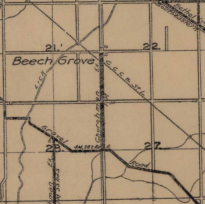
This road, before Beech Grove was built, stretched from a point in Washington Township, near Millersville, to the Johnson-Marion County line east of Greenwood. Part of this was considered to be part of the Churchman Free Gravel Road extension when the Big Four started buying the property. What became Albany Street (Troy Avenue in the rest of Marion County) extended from the Bottoms Road (now Harding Street) to what is now Kitley Road near the Hancock-Marion County line.

With the construction of the new railroad shops, and the new town, at Beech Grove, the railroad knew that it wouldn’t be long before it came up that two major roads in the county were being clogged by rail traffic. The elevation movement had already been in full swing in Marion County, although there were no such facilities completed to that point. Arguments were still being had about who was supposed to pay for all the bridges necessary to accomplish the plan. It was here that the planners decided to make sure that both carriage (and later car) traffic was unimpeded by the mass amounts of train traffic.

Emerson Avenue would be cut off just north of the Big Four railroad tracks north of the new town. This would put the cutoff just shy of 1/2 mile north of Albany, or 1/2 mile south of what would become Raymond Street. A new street would be built just north of the northern right-of-way of the railroad tracks, where it would connect 1/2mile east of Emerson, becoming the continuation of Troy Avenue. About 2/10’s of a mile east of Emerson, a new road would be built at a 90 degree angle to the railroad tracks, going under said railroad tracks, connecting to the new Second Avenue and the street running along the southern railroad right-of-way (to become Bethel Avenue) in Beech Grove.

1956 MapIndy aerial photograph of the Subway Street/Connection Street/Emerson Avenue/Bethel Avenue area near Beech Grove. west of the spur tracks leading into the Beech Grove Shops is a stub end of Emerson Avenue starting at Subway Street. It would connect to essentially a long driveway and a house west of Emerson and south of the railroad tracks.

The first street mentioned would be given the name “Connection Street.” The road that would go under the railroad tracks would be called “Subway Street.” The name subway actually has a historical context in Marion County. When traffic at Indianapolis Union Station got beyond horrible, the city of Indianapolis decided to build an underpass along Illinois Street, under the railroad tracks at the station. This was, for years, called the Illinois Street Subway, although it was more a bridge, even a tunnel, than a subway.

This wasn’t to say that Emerson Avenue disappeared completely between the two sides of the railroad tracks. A small section of Emerson Avenue existed from Subway Street north to a road, and house, 1/4 mile north of Albany Street. It existed this way for years. Until the early 1970’s, as a matter of fact.

Indianapolis Star, 15 April 1971. The photograph shows a four lane bridge in the middle of nowhere, over the tracks of what was, at the time, the Penn Central Railroad at Beech Grove. That bridge would be connected to the surrounding area, and would carry Emerson Avenue into Beech Grove from the north.

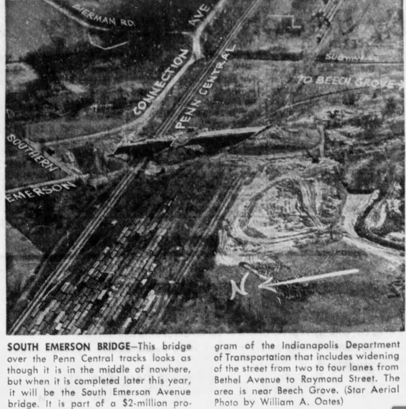
The new Emerson Avenue bridge over the Penn Central tracks, as they were called then, was completed in Spring 1971, although the connections to the new bridge weren’t complete. The road that connected to the house in the 1956 photo above would become the new Subway Street, which was turned to intersect and cross Emerson Avenue north of the old connection point.

1956 MapIndy aerial photograph with a 2020 overlay of then current conditions. This shows the driveway and the house, that would be removed when Subway Street was relocated with the building of the Emerson Avenue bridge north of Beech Grove.

The new ending of Subway Street would be at Fifth Avenue, instead of Second. Sections of the old Subway Street, from the new turn to Second Avenue, still exist to this day, almost 50 years later. And looking at the Google Map, or even MapIndy, will show that the property lines of the old Subway Street are still valid.

The railroad that created the town of Beech Grove is long gone. The Big Four became part of the New York Central, officially in 1930. The New York Central gave way, in 1968, to the Penn Central, which found the NYC merging with its long time rival the Pennsylvania. Soon after the creation of the National Passenger Rail Corporation, called Amtrak, there was a move to have Amtrak purchase the Beech Grove shops from Penn Central. This would happen in 1975.

A quick glance at the MapIndy property records leads to some confusing things, however. The property that the Amtrak shops is on does actually belong to the National Passenger Rail Corp. But it has to cross property that is still legally owned by the Penn Central Transportation Company. Now, I realize that the tangled web of property ownership and changing railroads can cause such things. But the property right next to it is owned by New York Central Lines LLC c/o CSX Transportation. As does most of the property north of the Amtrak Shops and south of the railroad mainline. The property records lead to a lot of fun reading. There are four different railroad companies legally listed as owners in that area: National Passenger Rail Corp.; CSX Transportation; New York Central Lines LLC (CSX); and Penn Central Corp (c/o C E Parker General Tax Agent Penn Central Trans Co, Chicago, Illinois). What’s strange is that all the property owned by the Penn Central is exempt from property tax.

Advertisement

Adeway

Many highways were given names in the Auto Trail era. One that always intrigued me, and I have yet to find a good history for, is a road that led from Indianapolis to Chicago. It was called the “Adeway.” The best map of the route that I have found, however, shows the road only going from Crawfordsville to Chicago. That map is from 1923, and is available at the Indiana State Library online.

The Adeway left Crawfordsville via Lafayette Avenue, traveling northeast before coming to Old Oak Hill Road near the intersection of current US 231 and Lafayette Avenue. The old auto trail would follow Old Oak Hill Road, and Oak Hill Road, until it becomes what is now Old State Road 55. It would follow what would become SR 55 in 1932 all the way to just east of Wingate. The original route crosses private property now, as it would connect directly to Crawfordsville Road in Wingate. Today, it turns west onto Wabash Street. The Crawfordsville Road intersection has been moved to make a perpendicular junction between the two roads. The original route can still be seen in grass markings in the following Google Maps snippet from 25 October 2020.

From Wingate, the original Adeway would follow what is now SR 55 to Newtown. From Newtown, the road would turn north along what is now SR 341, following that current state road to what is now SR 28. The auto trail turned west along the current SR 28 to Attica. At Attica, instead of turning onto Jackson Street, as SR 28 does now, it continued along Main Street, then Mill Street, and would cross the Wabash River along the old Mill Street bridge. The current state road, and US 41, crosses at Jackson Street.

After crossing the Wabash, the original auto trail would turn on what is now Old SR 55…but that route goes into private property today. It is best to use current SR 55 north of US 41 to approximate the old road. There are places where the current state road was straightened for ease of use and safety, but it is still very close to the original country road that would become part of the Adeway.

At Warren County Road 600 North, the Adeway turned west. It would curve several times, then turn west again on Warren County Road 650 North heading towards Rainsville. The old highway follows what is now Rainsville Road to just before SR 26. The road had been moved for safety at this point. The old Rainsville Road was part of SR 26 before the move. It can be clearly seen on this Google Map snippet of 25 October 2020.

The Adeway then turned north along what is now Meridian Line Road, right at the end of the current bypassed section. This would take travelers (mostly) due north through Fowler, where the street is still called Adeway. After crossing the current US 52, the street becomes known as Washington Street, but also happens to be SR 55 once again for its trip northward through the Benton County countryside.

In an effort to maintain its own way, the Adeway would turn west on what is now Newton County Road 1700 South. This is one mile south of the Illinois Corn Belt Route, which would later become part of US 24 across northern Indiana. The highway would follow SR 1700S until it would turn north along what is now US 41, travelling into Kentland.

Although the road had been straightened in places, the US 41 route approximates the old Adeway route. At Benton County Road 900 South (which east from US 41 is SR 16), the Adeway turned west again…to enter the town of Ade. One might assume that this is where the road got its name…but I am not going to jump to that conclusion until I have more facts.

From Ade, the old highway followed CR 275 West and CR 300 West north through Morocco and onto what is now US 41 (again) northward to Enos. The distance from Ade to Enos is 10 miles according to the Rand McNally Auto Trails Map of 1920. At Enos, the old route leaves the current state highway system again, this time for a short jaunt along CR 100 North to CR 400 West. Five miles later, the old route turns east, along CR 600 North, to connect to CR 300 West, which is still US 41. Just north of the intersection of US 41 and CR 600 North was a place called Conrad. The name still exists there, but not as a town of any kind.

The Adeway still follows US 41 north until just south of Lake Village. Here, the new road bypasses the town, while the old road, called Old 41, enters the town, as did the Adeway. North of Lake Village, the old road connects back to US 41, but doesn’t share that route long. Just south of Schneider, US 41 veers off to the northwest, while the old route continued straight through the town along what is now Parrish Avenue. At what is now 219th Avenue, the Adeway turned east, then north again along what is now Austin Avenue for its journey towards Lowell.

The journey continues along Austin Avenue until the junction of Belshaw Road, where the Adeway turned northeast to Cline Avenue, one-half mile east of Austin. The route entered Lowell on Cline Avenue, but left on Morse Avenue. Here the old highway followed Morse Avenue north and then west along the northern edge of Cedar Lake. It followed what is now Lake Shore Drive until it turns into 135th Avenue. There, it followed what is now 135th Avenue west across US 41 again, until Calumet Avenue near Brunswick.

Turning north along Calumet Avenue, the next turn would be at what is now 101st Avenue near Keitzburg. West along 101st, the Adeway then turned north again on what is now Sheffield Avenue. It then followed Sheffield Avenue/Hart Avenue (Dyer)/Sheffield Avenue until it became what is now Columbia Avenue. The old route then connected back to Calumet Avenue, which it followed all the way up to Indianapolis Boulevard, for a northwesterly turn towards Chicago. From the connection of Columbia and Calumet Avenues, the road is not part of the state highway system. At I-94, Calumet Avenue becomes part of US 41, and the Adeway follows that road designation into Chicago.

As is typical of the Auto Trail era, the journey of the Adeway from Crawfordsville to Chigago is nowhere near a straight journey. It winds through the northwestern Indiana countryside, meandering its way from point a to point b. But it would make one heck of a road trip, should one want to do such a thing.

1910: The National Road West of Indianapolis

Today, I want to show some map snippets of the National Road, and its replacement sections, as of 1910. Now, there is a small problem with this. The maps that I am going to use here are from the United States Postal Service from 1910. And while they are available from the Indiana State Library online, there are two that are noticeably absent from the collection: Clay and Marion Counties.

Marion County is easy to deal with. There are so many historic maps of Marion County available on the web that if I really wanted to, I could get something to cover the area. Clay County is an entirely different story. That is going to take some work.

Many people, today, are used to the straight ribbon of asphalt and concrete that is US 40 through Indiana. But that wasn’t the case when the road was created in the 1830’s. As was the standard operating procedure at the time, roads were built as straight as they could be. There was no heavy machinery to move a hill, or flatten a valley, in the early to mid 1800’s. Surveyors were extremely important at that time, to get the best road possible. If it could come in using less materials, and more importantly, less money, so be it. Most bridges across streams along the way crossed at a right angle to the stream. This was to make the bridge both safer and less expensive.

The hilly terrain of the area southwest of Indianapolis made the National Road surveyors a bit of hassle, as well. Hence, the relatively straight road that we know today was a lot of work and bending the old road into shape…and out of existence. The following maps show the road as it was in 1910. I wanted to give a comparison map from USGS maps…but the earliest available at this time is 1941, meaning that the road has already been replaced in most areas. And looking at Google Maps, there are very few sections that still exist of the original road that was replaced. But, I hope that these maps will start your own research into the original federal highway.

1910 USPS Map of Rural Delivery Routes in Vigo County west of the Wabash River.
1910 USPS Map of Rural Delivery Routes in Eastern Vigo County.
1910 USPS Map of Rural Delivery Routes in Western Putnam County.
1910 USPS Map of Rural Delivery Routes in Eastern Putnam County.

The map above shows the Reelsville bypass of the original National Road. I covered it in the article “National Road at Reelsville.”

1910 USPS Map of Rural Delivery Routes in Western Hendricks County.
1910 USPS Map of Rural Delivery Routes in Eastern Hendricks County.

US 50 West from Aurora

Today, I want to focus on US 50 on the other side of the state. Yesterday, I covered the original US 50 from Vincennes to Wheatland. Today, the last eight miles heading into Aurora. When the Indiana State Highway Commission was created in 1917, the future US 50 was included…but not as a single road. From Mitchell north to Bedford, then east, it was original state road 4. From Mitchell west, it was original state road 5.

The other thing I want to look at it the location of the original road. Unless you have driven in that section of Indiana, it is hard to fathom the difficulty in building a road through southern Indiana. Most of the state is (relatively) flat. Along the Ohio River, not so much. As someone whose family came from Pennsylvania, I realize the sheer insanity of building a road where the land has to be followed…not plowed through.

In northern and central Indiana, most roads can be built in a straightish line. Obviously, there are hills one has to skirt, and rivers to cross. But most of the land is relatively flat. That ends about 40 miles south of Indianapolis. And abruptly. I am only going to use snippets from one map (and a quick Google map) for this post…that of the 1943 USGS Topographic Map of the Aurora, Indiana, quadrangle. I have made five snippets…one a complete overview, and the other four are basically two miles at a time. I will be going from east to west in this case.

I know this is hard to see. That is why I have broken it down into smaller chunks. But this gives the overview of the whole area. Consider that each of the brown lines on this map are 10 feet changes in elevation. This gives a whole new meaning to up and down, eh?

The original US 50 entered Aurora from the north on what is now Main Street. North of Hogan Creek, Google Maps lists it as George Street. Where George Street meets US 50 north of Aurora, US 50 pretty much follows the old path, for a while, on its way to Lawrenceburg. A turn west on Third Street, and following the old road is still possible. Another turn south on Bridgeway Street, then west on Fourth Street, then original US 50 leaves the small burgh of Aurora. Google Maps shows the old road as Conwell Street. Before it connects into the current US 50, it turns south on Indiana Avenue, still staying south and east of the current US highway.

The problem with following the old road from here is that it has been cut off from the rest of the highway system. Indiana Avenue, before it would connect to current US 50 again, it curves east away from its old path. The Google map snippet to the left shows a blue line where the old road crossed the area that is now US 50, changing from what is now Indiana Avenue into Trester Hill Road.

As you can see from the topo maps of before the new road was built, the frontier path, later state road, that became US 50 originally skirted the edges of the topographical lay of the land. Without looking closer, I can not tell if it is a valley or the top of the ridge that the old road follows. A look on Google Earth shows it may be a valley that the road is keeping to.

The last four miles that I will be covering in this entry are pretty much using the old road as it was created in the early to mid 1800’s. Yes, the road is that old. The area that the road follows is called the Mount Tabor Ridge on this map. And the old road tries to keep climbs and descends as small as possible. This made sense, since getting horses, or even worse, oxen, to climb a hill was a chore in itself. Now, add a wagon, or saddlebags, and it got worse. There are stories abound that tell of someone hurt, or worse, killed trying to traverse steep hills.

This map shows the end of today’s coverage area. Not that I don’t want to keep going west from here. The next topo map available is the Dillsboro quadrangle, but it is dated 1958.

Following the original US 50 through the area gives an idea of what was required when a road was commissioned to go from point A to point B. Just looking at this route shows why the first team that went into “the wild” when it came to building a road would be the surveyors. Of course, this has always been true, for any road built in history. It wouldn’t have been good to draw a straight line on a map and just told someone to build that straight line. Especially through the landscape of southern Indiana.

Vincennes: The Lincoln Memorial Bridge

Few people in American history hold a place as high as Abraham Lincoln. The Kentucky native that became the 16th President of the United States, also spent time living in Indiana before moving on to Illinois, where he would become famous throughout the nation. It was decided that a bridge, supposedly marking the spot where Lincoln crossed into Illinois, would be built to connect Indiana and Illinois. It became the Lincoln Memorial Bridge.

The George Rogers Clark Memorial was soon to be constructed in Vincennes. As part of that memorial, a celebration on 3 September 1933 to dedicate a new bridge at Vincennes connecting Indiana and Illinois were scheduled. The date chosen for the dedication of the bridge was the 150th anniversary of the signing of the Treaty of Paris, bringing an end to the War for Independence and the creation of the United States of America as a separate country.

The Abraham Lincoln (George Rogers Clark) Memorial Bridge as shown in the Indianapolis News of 28 April 1934.

The bridge, when it was built, would carry US 50 across the Wabash from Vincennes, Indiana, to Lawrence County, Illinois. It would become a major link in that road for several decades. It would be a replacement of a bridge that spanned the Wabash from Main Street in Vincennes for many years.

The high approaches on the Indiana side were due to requirements by the War Department. The Munster, Indiana, Times of 17 July 1931 states that “rigid war department requirements forced the engineers to give the 1,850-foot bridge a clearance of 50 feet above the normal water level on the theory that some time navigation might be resumed in the Wabash.”

At one point, the plan of the city of Vincennes, and Knox County, was to build a boulevard between the George Rogers Clark Memorial and the Wabash River for the rerouting of US 41 along the new route. I am not sure if it was part of the plan, but Culbertson Boulevard runs from Main Street north to Hart Street between the railroad and the river. The US 41 idea never materialized.

In 1936, the bridge, as well as US 50, would be closed for one day. Sunday, 14 June 1936, would see the closing of US 50 in both Indiana and Illinois as the George Rogers Clark Memorial was dedicated at Vincennes. For four and half hours, detours of over 40 miles were in place as festivities were held to celebrate the GRC Historic Park dedication. Chief among those that would be on site would be President Franklin Delano Roosevelt.

The Abraham Lincoln Memorial Bridge still stands today, almost 90 years after the concrete structure was built. Yes, US 50 has been rerouted around Vincennes. The bridge now serves as Indiana State Road 441. And, according to Google Maps, the same road number in Illinois, although on the ground, there are no such markers in place that I have ever seen.

Straightening of SR 135 in Northern Washington County

Sometimes, the state moves very slowly when it comes to improving routes that, well, from first glance, should have been higher on the priority list. When SR 35 was created with the Great Renumbering of 1 October 1926, a lot of the route was pretty straight forward. That was until you got to just south of the Muscatatuck River in Washington County. Here, the road was the definitive hilly road.

Monroe Township, Washington County
1878

And the road had been that way for a long time. The 1878 map snippet shown to the left shows the Millport Ferry, which was in the location, roughly, of the current SR 135 bridge over the Muscatatuck River. From there, the “direct” route to the next post office, that being at Millport, winds its way through the hilly territory south of the river.

And this routing hadn’t changed. Until the Indiana State Highway Commission started designing a new road to replace the old one in 1954. Yes, nearly three decades after it became a state road, SR 135 (formerly SR 35) was getting some work to make it safer for travelers.

The bridge just west of the old bridge at the location of the old Millport Ferry was opened for bidding in September 1954. The design of the bridge was to be of seven spans, 28 foot of right of way for drivers, and 26 inch pedestrian walkways on each side. The bidding, opened on 21 September of that year, only included the bridge itself. Approaches to the bridge were to be let in another contract. It also didn’t include the tie in to the then current road north of the river.

The bridge that was being replaced had been contracted in 1883. The superstructure of that bridge, to be built completely of iron, was contracted to cost $23.00 a linear foot.

Work on the design of the new SR 135 section was completed in March 1954. According to the Seymour Tribune of 18 March 1954, “It is understood plans for the new highway are normally straight, with the new location scheduled to eliminate the present many curves on the highway, which now has about 40 turns, many of them sharp, in less than two miles.”

Construction on the new section of the road began on 6 June 1955, and according to the Jackson County Banner of 3 August 1955, was expected to “be completed about the first of next year.” The contract connecting the new SR 135 to the new Millport Bridge would be let later, as the bridge had not been completed by that time. Until that bridge was complete, the old bridge would be in use, and the new SR 135 would connect to the old SR 135 just south of the new bridge. The following Google Map snippet shows the old road, the connection to the new road, and the location of the old bridge.

The new section of road would open in mid-December 1955. The entire route was concrete, with the exception of the south approach to the new Millport bridge, which was graveled to allow traffic access to the new bridge. The gravel would be replaced with concrete the following summer. The old iron Millport bridge would be removed soon after the opening of the road.

Planning and Building I-65 in Southeast Jackson County

When the Federal Aid Highway Act of 1956 was made the law of the land, states throughout the United States started looking at how to cash in on the new superhighway plan. Rough routes had already been laid out. It was up to the states, more or less, to nail it down even more. While there were already sections of road that were going to be added to the new interstate system, I want to focus on one of the built from scratch sections that was planned. This section was so quick to be added to the highway system that it was announced in the Seymour Tribune on 14 February 1958. It would connect US 50 east of Seymour to Uniontown.

“Early Construction May Put New Road Near Here In Use Before Rest Of New Highway.” That was what the sub-headline read in the Tribune that day. Engineer for the Seymour District of the Indiana State Highway Commission, E. C. Willis, announced on that Valentines Day 1958 that the new superhighway, not mentioned by number in the article, was on the 1958 State construction plans.

According to the information put out by the ISHC, interchanges were to be built at US 50, just west of the then current US 31, and at SR 250, east of Uniontown. “This will permit the new stretch of the superhighway to be used between those two points before the remainder of the new limited access highway is completed.” The new highway would run roughly parallel to US 31, the major highway through the area.

“Survey parties of the state highway department still are working on staking the right of way for the proposed new road and one of them is now engaged between U. S. 50 and Kriete’s curve southeast of Seymour. Due to the deeply frozen condition of the ground from the recent continued near-zero temperatures, the survey party is encountering difficulties but is continuing its work with interruption for the extreme cold in order that the project can be rushed under this year’s schedule.”

The article goes on to state that right of way purchase at the Jeffersonville end of the new road had already begun.

Google Maps image of the area known as the Kriete Curve.

“The programming of the Uniontown-U.S. 50 stretch in the 1958 highway plans will permit the early construction of that section of the new road, which will include the utilization of the three sets of new dual-lane bridges south of the present Kriete curve, which have been under construction for some time and are about ready for use when a road is built to them.” I would assume from that statement that the state had already planned to move US 31 southeast of Seymour, and that bridges were already built pending completion of the road. With the creation of the interstate system, those bridges could be easily moved to the replacement highway, to be called Interstate 65. It is also safe to assume that the bridges in question crossed the Muscatatuck River, as shown in the Google Maps image.

The section of Interstate 65 in question was shown as under construction on the 1959 Indiana Official State Highway Map. It was shown as complete to a point north of SR 256 near Austin on the 1960 version of the same map. The same 1960 map shows completion of I-65 north from Jeffersonville to Underwood, with the section between Underwood and Austin under construction.

1975: Interurban in Tipton County, 40 Years Later

On 27 April, 1975, the Kokomo Tribune ran a full page story about with the headline “Clues to old interurban road still traceable in Tipton County.” The first paragraph was: “TIPTON – Nearly 40 years after the last of Tipton County’s interurbans was abandoned, it is still possible to retrace their rights-of-ways.” Many are the stories that were included in that article. I want to share some of it here today.

Along the old interurban lines, at that time, were many things that can immediately show the location of the old right-of-way. Bridge abutments are the most obvious. But there were also concrete collars, placed around electric poles for the safety of the pole. These collars were four feet high. They lined both sides of the tracks.

But the article goes on to point out other things that aren’t so obvious.

“In a goat pasture about a mile west of Hobbs, the interurban roadway appears as a flat plateau running alone the south side of Ind, 28.” Hobbs, according to Google Maps, is where SR 28 and SR 213 come together. Just south of SR 28 on SR 213, at CR 150S, “utility poles cutting through a field mark the southern edge of the interurban right-of-way.” Between the two mentions places in this paragraph, “a 20-feet-wide strip has been removed from a woods along the highway.”

The Union Traction Company of Indiana operated two interurban lines through Tipton County. The first, which would include the locations from the previous paragraph, ran from Elwood to Tipton through Hobbs. The other ran north through Tipton County, starting in Indianapolis, and connecting Atlanta, Tipton and Sharpsville before leaving the county. Another line that was planned, and construction started, but was never finished, would have connected Tipton to Frankfort.

The article states that “it is easiest today to find the old routes in rural areas. Construction and growth in cities have covered up the old tracks there. The interurbans often ran alongside highways and regular railroads, and the rural folks have not been in a hurry to obliterate the roadbeds.”

The line crossing Tipton County from the south followed the old Nickle Plate tracks across the county into Tipton. The Interurban repair yards, known as “the shops” (as related by 76 year old Dempsey Goodnight, a lineman and conductor for 10 years for the Union Traction Company), were located just north of Cicero Creek at Tipton. Work on the traction cars happened at this location. An electric substation was also contained on the yard’s property. By 1975, the old two story building was being used by a seed company.

That right of way left the Nickle Plate right-of-way to go west on Madison Street. According to Goodnight, between Independence and East Streets, there “used to be a stucco house. I remember when a street car jumped the tracks here and hit the porch.”

The ticket and dispatch offices, as well as the freight house, were located at the corner of Main and Madison Streets. By 1975, the freight depot, located on the west end of the ticket/dispatch office, had been torn down and replaced.

The route through Tipton turned north on Main Street, west on Dearborn Street, and north on Green Street. A boarding house for travelers was located at 612 Green Street, according to Goodnight. From there, the line headed northwest toward Sharpsville and Kokomo.

Jefferson Street was the entry point into Tipton for the line from Elwood, and made a loop in the downtown area. That loop was south on Independence Street, west on Madison Street, north on West Street back to Jefferson Street and its trip back towards Elwood.

“When the interurbans were built, the 75-foot utility poles were set in concrete. As the lines were abandoned, the poles were removed but many of the concrete bases were left in place, now looking like old lawn planters.”

Between Tipton and Hobbs, the old ROW was located about 20 feet south of SR 28. At Hobbs, the interurban followed CR 150S until just east of the SR 213 intersection, where it followed the old Norfolk & Western tracks, along the south side of the ROW, for four miles. Near CR 700E, the interurban veered south, just to turn back north to cross the N&W on a viaduct..

The ROW south from Tipton followed the old Nickle Plate as far as CR 500S, where it moved to the west around a cemetery. It then turned east again to cross a road, railroad and a creek. One of the abutments for that overpass still exist along CR 100 W and the Nickle Plate tracks, as seen here.

It looks like there may be a road trip in my future to see what is actually left of these two interurban lines. From what I can tell from Google Maps, there isn’t much. But, inquiring minds want to know. And If nothing else, I have an inquiring mind.

All photos in this blog entry came from the Kokomo Tribune of 27 April 1975 and were taken by Ron Sentman.

Connecting 16th Street from US 52 to SR 29

When I posted about routes to get to the Indianapolis Motor Speedway, someone of Facebook had posted a comment about the direct route using Indiana Avenue and 16th Street from downtown Indianapolis. I responded that part of the problem was that 16th Street, at the time (1919) did not exist between Lafayette Road and Northwestern Avenue (now Dr. Martin Luther King Jr. Street). After crossing the White River on the Emrichsville Bridge, the streets turned either north onto White River Parkway East Drive or southeast onto what was Crawfordsville Road.

The junction of Indiana Avenue/10th Street/Fall Creek/
Crawfordsville Road

It should also be noted that the most people, at that time, thought of Crawfordsville Road (now Waterway Boulevard) as the first choice as it was the one that had been in place the longest. Indiana Avenue came long after the Crawfordsville Road, and both of those streets connected to Indiana Avenue at 10th Street across Fall Creek. The moving of the south end of Waterway Boulevard, as it is today, didn’t happen until sometime after World War II.

But west of the White River, at 16th Street, was both US 52 (Lafayette Road) and SR 34 (16th Street). The state roads followed White River West Drive to Washington Street, because the road didn’t exist east of the river. This would connect US 52 (and possibly SR 34) to US 40 under what is now the Indianapolis Zoo.

It would be shortly after the 1919 map was published that 16th Street would be built from Indiana Avenue to the Emrichsville Bridge. But that was the extent of the new 16th Street. And even then, the 16th Street that was built was north of where it should have been. 16th Street through Marion County, of most of it, is along the half section line. Since the Emrichsville Bridge was angled north as it crossed west to east, 16th Street would be connected north of the half-section line where it belonged.

1926 Indianapolis map of the sections of 16th Street at that time between White River and Northwestern Avenue.

Fast forward to 1933. The Indianapolis Board of Public Works decided on several projects to be completed during the 1934 construction season. Two of the projects included bridges over Fall Creek. One of those would be on 16th Street. By this time, there was a short section of 16th Street from Gent Avenue to Fall Creek and just barely west of Northwestern Avenue.

The bridge over Fall Creek would allow connection between the two sections of 16th Street. Another part of the project would be widening the road that was there. In 1934 money, the project to construct and widen 16th Street from Northwestern Avenue to the Emrichsville Bridge would cost $280,000. The new bridge over Fall Creek would cost $250,000.

A remodel of the Emrichsville Bridge would also be part of the project. The northwest wing of the bridge would be cut off and the south sidewalk to be completely removed to create a better turning angle between the sections of 16th Street on either end. The city wouldn’t have to foot the entire bill for the new construction and widening. The city was working with the Indiana State Highway Commission for federal funding (at that time, a 50/50 split) for the project as the state would most likely (and did) add that section of 16th Street to the state highway system as part of US 52 and SR 34.

Another part of this project would be the widening of West Street from 16th Street to Bluff Road. From Washington Street north West Street was SR 29. From Washington Street south, it would become SR 37. Again, the cost would be shared between the ISHC and the federal government.

Indianapolis News, 27 October 1948

The Emrichsville Bridge would last another 14 years. It was torn down in 1948 to create a wider, more direct bridge for 16th Street/US 52/SR 34 across White River. Ultimately, the new 16th Street from White River to Dr. Martin Luther King Jr. Street would look as it does in the Google map shown below. It would also remain a state road until the late 1970s, when US 136 (formerly SR 34) was removed from inside the I-465 loop. US 52 had been the first removed and rerouted along I-465 when that road was complete from the northwest side to the southeast side.

Rockville State Road, US 36, near Bainbridge

When the original state roads were built, the state of Indiana created a road that connected Indianapolis to Rockville, via Danville. That road, still known today as Rockville Road in Marion County, is almost as straight as any road can get in this state. However, there were places where straight just wasn’t possible. Such a place is in Putnam County.

It should be noted that there were two things at play when it came to the building of the original state roads. First, the construction was done to keep costs to a minimum. There was no need to cat a path through a hill when one could just go around it. Path of least resistance was the motto of the day. Second, as a general rule, the state didn’t tend to take people’s property to build a road that would just be turned over to the county after it was built. This is one of the reasons that a road connecting two towns in early Indiana didn’t always go directly between two points. While it isn’t as noticeable on maps today, a quick glance at older maps shows the curvy way someone got from point A to point B in the early days of the state.

The Rockville State Road was (mostly) built along a section line, meaning very little property would have to be taken to create it. Generally, property lines in Indiana tend to work along the survey lines. Survey line separate townships, ranges and sections. Most of the time, property was purchased in one section or another, usually not crossing the section line. But there were several places that the old road did have to venture off of the survey lines beaten path.

One was east of Danville. Main Street through the city was the original Rockville State Road. When a short bypass between Danville and Avon was built, the old road was kept in place, but turned slightly at both the western and eastern ends. The following Google Map snippet shows the old property lines when it came to the western (Danville) end of old Main Street/SR 31/US 36. Main Street turns southwest, while the old property lines turn due west to connect to Danville itself.

The other section was a much larger bypass built by the state in 1933. East of Bainbridge, the old state road took a dive to the south of the survey line…sometimes venturing almost a mile south of the line itself. The following map is from 1911, showing the postal routes that were followed at that time, and showing the old Rockville State road in its original alignment.

As shown on the map, going west to east, the old road started turning southeastward in Section 12, continuing further southeast in Section 7, and hitting its southern most point in Section 8. From there, it worked its way back northeastward until it reached the section line again in Section 10. This created a variance from the section line that was nearly four miles long.

Editor’s Note: As is typical of the original surveys, sections along the western edge of the range [sections 6, 7, 18, 19, 30 and 31] are smaller than one mile wide. The Range Line between those sections listed above, and sections 1, 12, 13, 24, 25 and 36 of the range west, is known as a correction line. This can be spotted throughout the state, not only by the less than one mile wide sections, but the occasional deviance from a straight line going west to east. In Marion County, Shelby Street and Franklin Road are those correction lines…and looking at the roads crossing them shows the correction. The survey line along the north edge of the map is the township line, separating survey townships 15 North and 16 North. Following that line to the east, it becomes part of the Danville State Road in eastern Hendricks County, 10th Street (the geographic center) through Marion County, and the numbering center of Hancock County. It is also a correction line in the surveys, so sometimes survey lines jog a bit when crossing it as well.

This section of the old road was very curvy, narrow, and did not lend itself well to the pending explosion of traffic that would be coming its way with the creation of the Auto Trails and, later, the State Highway System. When the Pike’s Peak Ocean to Ocean highway was created, it followed the old Rockville Road from Rockville to Indianapolis. Thus, it followed this curvy, winding line through Putnam County.

Things would change in 1933, when the Indiana State Highway Commission announced that construction would begin on US 36 from Danville to Bainbridge. This project would complete the straightening of the federal highway from west of Indianapolis to the Illinois-Indiana State Line. The Indianapolis Star of 1 April 1933 reported “a twenty-five mile detour from Danville to Bainbridge on United States Road 36 over pavement and dustless type road has been established to take care of traffic pending completion of new pavement between Danville and Bainbridge which will complete the project from Indianapolis to the Illinois state line.”

The above Google map snippet shows the exact same area as covered by the 1911 USPS map shown above. The route of US 36 through the area, shown in yellow, is the 1933 bypass built by the ISHC. The old road is still very narrow and winding, but still can be traveled to this day. The Indiana Official Highway map of 1933 shows the new road under construction, with the old road removed from the map. By the time the next official map was released for June 1934, the new road was completed and opened. The following is the 1936 survey map of Putnam County roads, including road width, constructing materials and bridge of the same area.

The new roadway included bridges marked as AS, AT, and AU on this map. The old road included CN, CM, CH, CG, and CK. (Note, they are marked on the map in lower case letters. I am using upper case to denote them since it is easier to read.) Both AS and AU were built 24 feet wide, while AT was built 20 feet wide. All three had a safe working load of 20 tons.

The old road’s bridges were a bit more complicated. CN was 12.7 feet high, 12.7 feet wide, and had a safe working load of three tons. CK was 16 feet wide and could handle 15 tons. CM was 19.5 feet wide, with a working limit of 20 tons. This would make it almost equal to the bridge that replaced it (AT), only being six inches narrower with the same work load limit. Both CG and CH were 20 feet wide with a 20 ton safe load limit.

The old road, according to the figures on the 1936 map, had a right-of-way 40 feet wide. The new US 36 through the area had a right-of-way of 60 feet in width. Most of the county roads in the area had a right-of-way narrower than the old Rockville State Road, usually less than 10 feet.

The other part of this realignment project was through Bainbridge itself. The old road traversed the town along Main Street. The new road bypassed Main Street to the north…by only one block. It still does to this day.

Jim Grey, on his old web site, covers the sections of the old road that connect to the current US 36 fairly well. That page is at: http://www.jimgrey.net/Roads/US36West/04_Bainbridge.htm. I think I have read somewhere that this website will be migrated over to his WordPress blog, “Down The Road.” If this is the case, get it while you can. And who knows, maybe after all the “stay at home” mess is over, I might make a trip out to this section of the old road to take some onsite surveys. (I would love to say take pictures…but my lack of photography skills is only surpassed by my complete lack of patience to take the time to make them good. Not gonna lie here, folks.)