Railroads of Indiana, 1850

One of the beautiful things of the internet, one of the things that make doing something like the Indiana Transportation History blog so easy, is the access to a world of information. Yes, some is accurate, and some isn’t. But my favorite resources, as I have shown over the past almost two years, is maps. While maps can be wrong at times, or more to the point, based on “future” information that doesn’t come to be, they are still a great resource if you can figure where they went wrong.

Today, I found another map that grabbed my interest. Looking at a map of railroads in Indiana, even today, there are railroads all over the state. A railroad map from the turn of the 20th Century is a spider web of routes crossing the state in all kinds of directions. But the map that I found today is one of Indiana in 1850. It is an interesting look what was, and how many changes have come about in the 170 years since it was printed.

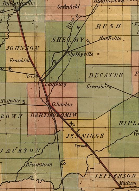
When railroads started being built in the state, just like everywhere else, it was a jumble of little companies, usually with destination cities in the company title. There were 15 railroads on the map at the time, with some that were proposed. One of them was in Ohio, but would later be part of an Indiana system when it was completed. The map that I found showed the railroad routes as straight lines, not the actual routes themselves. I am going to cover them in the order the map numbered them.

Number 1: Madison and Indianapolis Railroad. I have covered this railroad many times, as it was the first long distance railroad built in Indiana. The engineering of this route, which included the steepest railroad tracks in the nation, was top notch at the time. Although it was originally been on the cheap, using iron strapped rails instead of the “T” rail that would become standard (and much safer) later. In the end, it would become part of the Pennsylvania Railroad.

Number 2: Shelbyville Lateral Branch. This line was built as a feeder road to the Madison & Indianapolis. Its history isn’t terribly long. It connected the Madison & Indianapolis at Edinburgh to Shelbyville, opening up farm produce from Shelby County to the world at large. The railroad, depending on what history you read because it is very spotty, would last around five years before it was abandoned.

Number 3: Shelbyville & Rushville Railroad. Shelbyville was a “rail center” for a little while in the 1850’s and 1860’s. This route connected the two title towns, opening Rush County to the markets available on the Madison & Indianapolis.

Number 4: Shelbyville & Knightstown Railroad. Another short lived railroad, that would open southern Henry County to the same markets served by the above three. This company would last less than a decade, according to the source. Again, the history is spotty about this road at best. Later, part of route would become part of a railroad again, but instead of connecting Knightstown to Shelbyville, it would connect to Rushville.

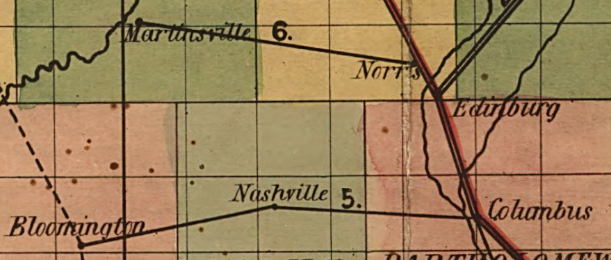
Number 5: Columbus, Nashville & Bloomington. Trying to find any history on this road is difficult at best. I am not even sure if it existed at all. This will require more research.

Number 6: Martinsville Branch Railroad. Another road, like the one above. History is hard to find like the one above. It connected the Madison & Indianapolis to Martinsville. Later, the same connection would be made, in 1853, from the M&I at Franklin to Martinsville. That railroad would would be the Fairland, Franklin & Martinsville.

Number 7: Indianapolis & Bellefontaine Railroad. This route connected Indianapolis to Pendleton, Anderson, Muncie and Winchester to ultimately Bellefontaine, Ohio. Down the road, this would be one of the founding parts of the Big Four Railroad. It is still in use today as part of CSX.

Number 8: Indianapolis & Peru Railroad. Today, this is mostly known as the Nickel Plate connecting Indianapolis, Noblesville, Tipton, Kokomo and Peru. Or at least what’s left of it. At one point, for about nine months, it was consolidated with the Madison & Indianapolis creating a route from Madison to Peru under one umbrella. Shareholders, and the courts, put an end to that marriage, creating two separate companies again.

Number 9: Indianapolis & Lafayette Railroad. Another constituent part of what would become the Big Four Railroad. At one point, at the Indianapolis end, the line came down alongside the Central Canal. It would be also be the scene of a large train wreck that would kill members of the Purdue University football team (Part 1 and Part 2).

Number 10: Lafayette & Crawfordsville Railroad. This railroad would later become part of the Chicago, Indianapolis & Louisville, later known as the Monon. At the end of this article, I will show the only proposed railroad that in included on this map, which would be a connecting route from Crawfordsville to Bedford, thus creating the remaining part of the Monon mainline through western Indiana.

Number 11: Terre Haute, Indianapolis & Richmond Railroad. The original plan for this railroad was to connect the entire state, east to west, following roughly the National Road corridor. It would never be built past Indianapolis. Over the years, it would become part of the Pennsylvania Railroad.

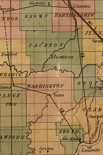
Number 12: New Albany & Salem Railroad. This would be the southern end of what would become the Monon. There were several companies between the New Albany & Salem and the Monon. I covered the history of the Monon in two parts, part 1 and part 2.

Number 13: Jeffersonville & Columbus Railroad. Most references to this road refer to it as the Jeffersonville, or “J.” The plan was to build the line all the way to Indianapolis. The problem came with the management of the Madison & Indianapolis. As the first railroad, the M&I assumed the attitude that they were the kings of the state’s railroads and others, especially direct competitors like the “J,” should just be good little kids and do what they are told.

There is a story about the M&I not wanting to help another railroad, because they weren’t in business to provide charity to other companies. The company they turned down would be the THI&R, which would be far more successful than the M&I in the end.

The M&I refused to cooperate with the J. So, ultimately, the J not only invested in feeder lines, taking traffic from the M&I, they started building a parallel track to the M&I. Ultimately, the J would end up buying the struggling M&I. And, like the M&I, would become part of the Pennsylvania system.

Number 14: Lawrenceburg & Greensburg Railroad. This road was built to connect the markets of Decatur and Ripley Counties to the markets at Cincinnati. Ultimately, the plan was to build the road all the way to Indianapolis, allowing a more direct route from the Hoosier capital to the Queen City of the Ohio. Traffic would be barged from Lawrenceburg to Cincinnati, which was faster than the already in place barged traffic from Madison to Cincinnati.

Number 15: Cincinnati, Hamilton & Dayton Railroad. The only reason that I am mentioning this is because it would be the foundation of what would ultimately become the Baltimore & Ohio connecting Indianapolis to Cincinnati directly.

As mentioned above, the only proposed railroad on this map is the future Monon route connecting Bedford to Crawfordsville. Several towns along the proposed route would not be serviced by any other railroad company for years. And today, most of this route no longer exists, having been given back to the locals when the bigger companies were created, and the route became excessively redundant.

There is one more transportation facility included on this map. The Wabash & Erie Canal from Evansville to Fort Wayne and beyond is marked on it.

The entire map that I used for this article is available here: Railroad map of Indiana, by Col. Thomas A. Morris, Civil Engineer, | Library of Congress (loc.gov)

SR 32/SR 67 in Madison and Delaware Counties

Today on a map of Indiana, there are two state highways connecting Anderson and Muncie. As the subject suggests, they are SR 32 and SR 67 (even though SR 67 actually hasn’t entered either for decades. But it wasn’t always that way.

When the Great Renumbering happened in 1926, SR 32 only connected Crawfordsville to Anderson, much like the Auto Trail of the same name. SR 67 would be applied to Ohio Avenue and Mounds Road. The original road crossed what is now the Anderson Municipal Airport to connect (as now Anderson Road) in Chesterfield to what is now SR 32. From there, SR 67 continued its journey to Muncie. While technically Mounds Road and Anderson Road are still connected, the road in place today is a replacement around the airport, as the old road west straight across what is now the runway.

At Muncie, what is now SR 32 east of the city was originally SR 28. That would change in 1931, when SR 28 (east out of Muncie) was changed to SR 32. According to the map sources that I have seen, however, the only state road connecting Anderson to Muncie was still SR 67. In 1933, the connecting road would share both the numbers 32 and 67.

Things got interesting in the Anderson area in 1934/1935. Two new state highways were being constructed along 53rd Street and 38th Street. The 53rd Street route was being added to the state highway system from SR 9 to Middletown as SR 236. The 38th Street route was, from information available, to become an Anderson bypass of SR 67. That route would travel across 38th Street to Rangeline Road, then connect to the then current SR 32/67 along Mounds Road.

Things changed again in 1936, when it was decided by the State Highway Commission to build a new state highway staying south of the Big Four (“B” Line) railroad, staying south of Daleville, and crossing Delaware County in a relatively straight line to Sharps, then turning toward, but not actually entering, Muncie until meeting SR 21/US 35. By this time, SR 236 was completed to Middletown. The new route would use 53rd Street, and the 38th Street route was removed from the pending state highway status.

53rd Street in Anderson was officially made SR 67 from SR 9 to Rangeline Road in 1937. SR 32 still used the Ohio Avenue/Mounds Road/Anderson Road route. The two state roads would reconnect using what is now Madison County Road 300 East. This short section would connect Mounds Road (SR 32) in the north to Union Township Pike (SR 67) in the south.

The new route of SR 67 would be along the corridor that is still SR 67 today across Delaware County. This would be what is also Delaware County Road 550 South to Honey Creek Road. From there, would again follow what is now SR 67 for a short distance, then the current route turns east before the 1937 route continued northeast to Fusion Road. It would then turn northeast, then north, along Madison Street, where it would combine with SR 21/US 35 into Muncie.

The new State Road 67 route would be completed by 1938. At that time, the State Road 32 route would still be located on the Mounds Road/Anderson Road route. What is now Madison County Road 100 N was given the number SR 232 from between Mounds Road (SR 32) to Union Township Pike (SR 67).

The next change would occur in 1960, when SR 32 was rerouted out of Anderson along the Third Street/University Boulevard corridor. Here it would connect to the original SR 67/32 route at Chesterfield. The old SR 32, along Ohio Avenue/Mounds Road to the Union Township Pike route of SR 67 would be changed to SR 232, which most of it is today. In 1965, the designation SR 232 would be truncated into Mound State Park, no longer connecting to a soon to disappear SR 67.

SR 67 would be rerouted along Interstate 69 from SR 9/67 between Pendleton and Anderson to near Daleville. The 1937 route of SR 67 would be returned to Madison County, and is currently referred to as Old State Road 67.

In the 21st Century, slight changes in SR 67 in Delaware County would occur, making the very long “S” curve that exists today.

SR 67 in Northeast Marion County

When the Great Renumbering occurred on 1 October 1926, the number 67 was assigned to the Pendleton Pike connecting Indianapolis to Pendleton, through Lawrence and Oaklandon. This would be part of the greater State Road 67 stretching from Vincennes to Muncie…and later to the Ohio State Line. But the route in Indianapolis, and northeast Marion County, would carry the road along Massachusetts Avenue to the city limits, where the name would change to Pendleton Pike.

One of the first changes would involve the adding of US 36 to the same path. Although US 36 is higher in priority, most of the businesses along the old route kept the “67” as part of their names if it included it. As a matter of fact, I find it hard to believe that even today, there are no businesses along that road that include the number “36,” at least as I can recall. But there is a Motel 6t7…with a US route shield shaped sign…as shown to the left.

Changes were being planned for the road in 1933, when it was decided that SR 67 (and as a result, US 36) would be three laned from Indianapolis to Anderson. This would result in a change in the historic path of the Pendleton Pike from northeast of the then town of Lawrence to just south of Pendleton. In Oaklandon, for instance, the old SR 67 followed the current path of Pendleton Pike to what is now Oaklandon Road (formerly Germantown Road, named after the village that is now currently under water in Geist Reservoir at the Marion-Hamilton County line). The road then went north on Germantown (Oaklandon) to Broadway, turning northeast on that street. The old connection between Broadway (old SR 67) and the current Pendleton Pike (US 36/SR 67) still can be seen northeast of Oaklandon.

In 1935, the State Highway Commission decided that the number of miles inside the City of Indianapolis that it had to maintain would best be served if the number was lower. At the time, most of the northern city limit was at 38th Street, the dividing line between the middle tier and northern tier of townships. Where the Pendleton Pike now ends, at 38th Street west of Shadeland, was where the city ended at that point in history.

A bridge contract was let to Edward F. Smith to build a five span, 217 foot long bridge over the Big Four Railroad along 38th Street west of the intersection with SR 67, which was Massachusetts Avenue/Pendleton Pike. The bridge, in 1935, cost $143,825.01. The Indianapolis News of 25 May 1935 states that “Thirty-eighth street, with this and other contemplated improvements, is to become State Road 67. Construction will start in a few days and is scheduled to be completed by November 15.” Plans to move SR 67 to the 38th Street corridor were mentioned in newspapers as far back as June 1933, when plans for a new Fall Creek bridge on 38th Street, near the State Fair Grounds, were in the works.

While construction was going on between Indianapolis and Anderson in 1935, the official detour route had changed in late June. The original detour involved taking US 40 to Greenfield, then north on SR 9 to Pendleton. The new official detour recommended using SR 13 (became SR 37, now Allisonville Road) to SR 32 in Noblesville, then SR 32 to Anderson. This was recommended over the SR 38 route to Pendleton since SR 32 was a hard surface road, and large section of the newly added SR 38 were still gravel.

By 1937, SR 67 would find itself skirting Indianapolis, at least on the north side, along 38th Street. The old SR 67, Massachusetts Avenue, would find itself labelled SR 367. The three lane project between Indianapolis and Anderson would be completed, and Oaklandon would find itself bypassed by one of the two transportation facilities that made it possible. Now, most of what is left of SR 67 on the northeast side of Marion County (Pendleton Pike from I-465 east) is at least five lanes wide…but quite a bit of it is seven.

1917: Main Roads to Fort Benjamin Harrison Need Work

When Fort Benjamin Harrison was built in Lawrence Township, in northeastern Marion County, getting there was quite the chore. It has been built along the Big Four’s Bellefontaine, or Bee, line. This allowed steam locomotives to pass by the new Army post on a regular basis. The Big Four, with its affiliation with the New York Central, could get Army traffic to and from the fort to almost any place in the United States without much effort.

The workforce for the new fort would come on either the Bee line, or the new Indiana Union Traction line that connected Indianapolis to Anderson, Muncie and Fort Wayne. Although it didn’t last much more than three decades, this was an important way to access the fort. The station for that interurban line still exists…and is open to the public as a Mexican restaurant (as of this writing) called the Hacienda.

But automobile traffic was becoming more and more important. Even more important was the transit of Army vehicles to and from Fort Benjamin Harrison. To that end, in the spring of 1917, the commander of the station, General Edwin F. Glenn, sought to get improvements to the road system to the fort. With this in mind, he held a conference with Marion County government and business leaders to share what he had in mind.

The Indianapolis Star, 10 June 1917. Map of the north east side of Marion County, showing improvements needed to access Fort Benjamin Harrison.

First and foremost in the General’s mind was the main road to the fort – the Pendleton Pike. Technically, the Pendleton Pike started at the limits of the City of Indianapolis at Bee Line connection to the Indianapolis Belt Railway just east of Brightwood Avenue (Sherman Drive). West of that point, it was called Massachusetts Avenue. The county had taken over the Pendleton Toll Road in the late 1880s. But little was done for its improvement or maintenance. By the time the Army created the fort, the road was little more than a connection to other roads in rural Marion County and downtown Indianapolis. Many battles were fought about the improvement of the road, lasting past the end of World War I, when such improvements were vital.

The Pendleton Pike, in 1917, was being improved…slowly but surely. The plan was to concrete the road from the Indianapolis City Limits to 38th Street, just west of what is now Shadeland Avenue. From there, the first of the two sections to the fort’s main north-south entrance, would be improved with heavy stone. This would take the heavy stone from 38th Street to the old Noblesville-Franklin State Road, or Franklin Road. The next section would be graveled. This section ran from Franklin Road to the Yerger or Acre Free Gravel Road, now known as Post Road. The section of the Post Road, connecting Pendleton Pike to the interior of Fort Benjamin Harrison, was being hard surfaced with a “special preparation,” according to the Indianapolis Star of 10 June 1917.

The next road to get attention was the “54th Street Road,” connecting west from the fort to Millersville. Those of you from the area might be a little confused. The village of Millersville was along the Fall Creek, just inside the Washington Township border at what is now Emerson Way. The main drag from Fort Benjamin Harrison is now called 56th Street, not 54th. That road was built along the half-survey line starting where the Millersville and Fall Creek Free Gravel Roads come together near what is now Emerson Way at Millersville Road. The highlighted section of the following MapIndy photo, from 1952, shows the original route connecting the Millersville Road to the old Fall Creek & Mud Creek Road. (At the time, what is now Rucker Road continued south of what is now Fall Creek Road. It would be that way until sometime before 1962, when two lakes were built. The Rucker Road extension would finally be taken out sometime between 1979 and 1986.)

The Millersville Road, according to the Indianapolis Star “is by no means a direct route to the fort. It begins at Thirty-eighth street and Fall Creek and meanders northeast about eight miles to the famous Baker’s bridge and thence southeast a quarter of a mile to the fort grounds.” Baker’s Bridge is along the old Noblesville-Franklin State Road, now called Boy Scout Road, in the northwest corner of the Fort Benjamin Harrison grounds. General Glenn wanted the entirety of the Millersville Road covered with gravel…a job that, according to the General, with five wagons in two days. The first three miles of the Millersville Road had already been improved with asphalt. The next half mile being oiled gravel. The rest of the road was gravel…and work was being done at the time to repair damage done by large, heavy, loads transiting the road.

Other roads being worked on for access to the fort were the National Road from Irvington to Acre Road, Emerson Avenue, Arlington Avenue, 34th Street and the Acre Road itself.

At the time, National Road was the actual name of the Washington Street extension outside the limits of the City of Indianapolis at Sheridan Avenue in Irvington. West of Sheridan, it was Washington. East of that point, it was the National Road. The first mile of the National Road, from Sheridan Avenue, was being concreted. That would end near what is now Shortridge Road and Washington Street. The next two miles from Shortridge Road east were already concreted at that time. That would take it to a point east of Acre (Post) Road. The Acre Road, as of 10 June 1917, was closed for construction of a stone road stretching five miles north to the Pendleton Pike and into the fort.

Emerson and Arlington Avenues were also under construction at the time. Both were being concreted from Washington Street (both are west of Sheridan Avenue) to the Pendleton Pike. Emerson Avenue met Pendleton Pike at roughly 30th Street. Emerson Avenue, at least the southern section of said, ended at the Bee Line. Neither 30th Street nor Emerson Avenue crossed the railroad tracks, and passage past those tracks was done at an underpass on 32nd Street.

Arlington Avenue meets Pendleton Pike (now Massachusetts Avenue) at 34th Street. Improvements along 34th Street included asphalt paving from the Lake Erie & Western (Nickel Plate) Railroad crossing for three miles to the east to what was the northern section of Emerson Avenue. From there to Arlington Avenue, 34th Street was a stone road. Prior to being called 34th Street, the road was the Fall Creek & Warren Township Free Gravel Road.

It would take some time until the roads were improved for to the General’s liking. With the creation of the Indiana State Highway Commission in 1917, the National Road was taken over as Main Market Road #3. It wouldn’t be until 1923 that the Pendleton Pike would find itself part of the state highway system, entering that system as Original State Road 37. By then, the war was over, and traffic to Fort Benjamin Harrison had, while not stopping completely, had slowed considerably as it normally does after the completion of a war. The fort would, eventually, get its connections to the road system other than SR 67/US 36 (Pendleton Pike). In 1941, 56th Street west out of the fort would become part of SR 534, a designation it would only hold for a few years before that state road was routed straight down Shadeland Avenue. With the building of the Interstate system, which was technically built for the defense of the United States, Fort Benjamin Harrison would find itself with two exits from I-465 (Pendleton Pike and 56th Street) and one on I-70 (Post Road). I suppose the Post Road exit on I-74 could technically be listed as part of that…but it is quite a distance from the Fort.

End of Year 1940: ISHC Projects and Contract Bidding

On 13 December 1940, it was announced that the Indiana State Highway Commission was about to open some bidding on projects, and that the bidding would be received by 31 December. These projects included four grade separations, eight bridges and thirty miles of paving and resurfacing.

Sherman Drive and Big Four, 1937
Sherman Drive and Big Four, 1962

One of the biggest projects on the bidding list involved a city street in Indianapolis. Sherman Drive, a major thoroughfare three miles east of the center of Indianapolis, crossed the Big Four Railroad northeast of the railroad’s major yards at Beech Grove. That yard is just over one mile southeast of the Sherman Drive. According to the press release from the ISHC, “among the grade separations to be built are a 13-span structure on Sherman Drive southeast of Indianapolis, to carry traffic over the CCC & St. Louis Railroad yard.” As shown in the picture to the left, this was an at grade crossing of multiple tracks. The picture at the right shows the same area of Sherman Drive in 1962.

Another bridge project opened for bidding at this time was grade separation on the Marion State Road 9 Bypass, crossing over the Chesapeake & Ohio and the Pennsylvania Railroads. That bridge was planned to be a seven span structure. Another bridge to be built in the Marion area was a 392-foot structure over the Mississinewa River on the same SR 9 bypass. The bridge was to have a 28 foot roadway and sidewalks.

Paving projects included in this round of bidding were: 1.291 miles of US 50 realignment in Washington, Daviess County; 4.938 of SR 1 paving from Leo north to Allen-Dekalb County Line in Allen County; and paving 2.391 miles of SR 9 bypass (Baldwin Avenue) from Second Street in Marion, Grant County.

Another SR 9 project in Grant (and Huntington) County included widening and resurfacing 21.30 miles of SR 9 from 1/2 mile north of Marion to Huntington. The road was to be widened to 22-foot wide. Also in Madison County would be the widening of three miles SR 9 from SR 67 north to the Anderson city limits.

The last road project would be the widening and resurfacing of US 31 from the north edge of Franklin to the south edge of Greenwood, through Whiteland and New Whiteland. This contract would include 9.1 miles of highway.

Guard rail projects were also part of the bidding. Those installations would be in Adams, Allen, Dekalb, Elkhart, Floyd, Franklin, Grant, Hamilton, Hancock, Henry, Huntington, Jackson, Jennings, Johnson, LaGrange, Lawrence, Madison, Marion, Miami, Monroe, Morgan, Noble, Randolph, Steuben, Union, Wabash and Whitley Counties. These were on roads 3, 6, 9, 13, 15, 18, 20, 22, 24, 27, 29, 31, 37, 44, 50, 52, 67, 109, 128, 150, 209, 327, 427 and 434.

Indianapolis and the Original ISHC State Road System

I have posted much about the creation of the Indiana State Highway Commission. As of the posting of this article, the age of the Commission is either 103 or 101 years old. The original ISHC was established in 1917…but met with a lot of problems. It was finally nailed down in 1919 and made permanent.

This also creates a dating problem when it comes to the state highways. The first five state highways, then known as Main Market Roads, were established in 1917 with the original ISHC. Two of those original Main Market Highways connected to Indianapolis. The original National Road had been given the number Main Market Road 3. The Range Line Road, connecting Indianapolis to Peru, and through further connections, to South Bend, was given the Main Market Road 1 label.

When it was finally established, the ISHC changed the name of the Main Market Road to State Road, in keeping with other states surrounding Indiana. The markers used along the roads, painted onto utility poles like the old Auto Trail markers were, resembled the image to the left…the state shape with the words “STATE ROAD” and the route number. In this case, as of 1920, State Road 2 was the original route of the Lincoln Highway through northern Indiana.

The state highway system was designed to, eventually, connect every county seat and town of over 5,000 population, to each other. Indianapolis, as the state capital and the largest city in the state, would have connections aiming in every direction. Most of those roads marked with the original numbers would still be state roads into the 1970s and early 1980s, before the Indiana Department of Highways started removing state roads inside the Interstate 465 loop…and INDOT finishing the job on 1 July 1999. These road were removed for state statutory limitation reasons, and I have discussed that in a previous blog entry. So I won’t do it here.

The original state road numbers that came to Indiana varied greatly, as did their directions. There were no set rules when it came to state road numbers. They were assigned as they came…and stayed that way until the first renumbering of 1923, or the Great Renumbering of 1926.

Let’s look at the original state roads in Marion County, some of which actually did not reach Indianapolis itself.

State Road 1: As mentioned before, State Road 1 was originally called Main Market Highway 1. North of Indianapolis, it followed the Range Line Road, a local Auto Trail, through Carmel, Westfield, to Kokomo and points north. The route north followed Meridian Street north to Westfield Boulevard, then Westfield Boulevard on out to Carmel and beyond. In Carmel, the old road is still called Range Line Road, and serves as the main north-south drag through the town, as it does in Westfield.

South of Indianapolis, State Road 1, like its Main Market Highway predecessor, followed the old Madison State Road out of the city to Southport, Greenwood, Franklin and Columbus. The original SR 1 route is still able to be driven through the south side of Indianapolis, with the exception of the section replaced in the 1950s by the Madison Avenue Expressway. But Old Madison Avenue exists, if you can find your way back there.

While the entirety of original State Road 1 became US 31 with the Great Renumbering, bypasses in Marion County were put in place very early. The northern section, through Broad Ripple, and Carmel was replaced as early as 1930. The southern section, including the Southport/Greenwood bypass, was put in place in the 1940s.

State Road 3: As mentioned above, Main Market Highway/State Road 3 followed the National Road through Marion County. One exception to this is the section of the 1830s National Road that crossed the White River downtown. That section of the old road was removed in 1904 with the demolition of the National Road covered bridge and its replacement with a new, and short lived, Washington Street bridge. With a couple of exceptions other than that (the Bridgeport straightening of the early 1930s, and the new Eagle Creek bridge built in the late 1930s), the old road was followed very accurately until the mid-1980s with the creation of White River State Park. The successor to original SR 3, US 40, was moved to make room for the park. Both US 40 and US 31 lost their designations on 1 July 1999 with the removal of those two routes inside the I-465 loop.

State Road 6: This old state road was a through route when it came to Marion County. From the north, it followed the route of the original Indianapolis-Lafayette State Road from Lebanon. After passing through downtown Indianapolis, it left the county using the original Michigan Road on its way to Shelbyville and Greensburg. The original State Road 6 followed the Michigan Road Auto Trail, not the Historic Michigan Road, meaning it still went to Madison, but it went by way of Versailles, which the historic road did not. With the Great Renumbering, the northern SR 6 became US 52, while the southern SR 6 became SR 29 – later to be renumbered again to US 421.

State Road 22: This road, as it was originally laid out, only lasted from 1920 to 1923. Out of Indianapolis, it followed the old Mooresville State Road through southwestern Marion County. It was designated the original route from Indianapolis to Martinsville, as described in this blog entry. This road will be discussed again a few paragraphs from now.

State Road 39: Another 1830s state road that was taken into the Indiana State Highway Commission’s custody in 1919. This road followed the old Brookville State Road from the National Road out of the county through New Palestine to Rushville and Brookville. The original end of that road, both the 1830s original and the 1919 state highway, is discussed here. The road would become, in October 1926, the other section of US 52 through Indianapolis. It would also eventually become the first state highway removed inside the I-465 loop in Marion County. And even then, it would be rerouted in the late 1990s to go the other way around the county.

That covers the 1919 highways. More would come to Marion County before 1923.

State Road 12: Originally, this road, north of Martinsville, was the old State Road 22 mentioned above. When a new SR 22 was created, the SR 12 number was continued from Martinsville to Indianapolis along the old Vincennes and Mooresville State Roads. This road, in October 1926, would become part of the new State Road 67.

State Road 15: While the southern route of the Michigan Road was State Road 6, the northern part, heading off to Logansport, was added later and given the number State Road 15. The entire route of the historic Michigan Road would never become a state highway, but major sections did…although late in the creation of the state highway system. With the Great Renumbering, this road became SR 29, and in 1951, redesignated, like its southern half, US 421.

State Road 22: Here we go again. State Road 22 was given to the route between Indianapolis and Paoli. In 1919, that included the route along the west bank of the White River from Martinsville to Indianapolis along the Mooresville Road. This was changed by 1923 to keep SR 22 on the east side of White River, where it followed the old Paoli State Road, and the Bluff Road, through Waverly to the south edge of downtown Indianapolis at Meridian and South Streets. This was one of the routes of the Dixie Highway through Indianapolis, and would later become part of SR 37 in 1926.

State Road 31: In 1920, when this road was originally created, it turned south to connect to the National Road west of Plainfield. It had followed the Rockville Road from Montezuma to Danville, then turned southeasterly to meet State Road 3. By 1923, the road was moved from what would later become part of what is now SR 39 to continuing on the Rockville Road into Marion County. State Road 31 would meet the National Road outside the city limits of Indianapolis at what is now the intersection of Holt Road and Washington Street. It would become US 36 before it was extended along the new section of what is now Rockville Road to the intersection at Eagle Creek with Washington Street.

State Road 37: One of two state road numbers that still served Indianapolis after the road numbers were changed in October 1926 (the other being State Road 31). The original State Road 37 left Marion County in a northeasterly direction on its way to Pendleton, Anderson and Muncie. Inside the city limits, the street name was Massachusetts Avenue. When it reached the city limits, the name of the road changed to Pendleton Pike. This still occurs today, with the name change at the old city limits at 38th Street. In October 1926, the number of this road would change to State Road 67.

There were two other major state roads in Marion County, but they weren’t part of the state highway system until after the Great Renumbering. One was the Crawfordsville State Road, part of the original Dixie Highway, connecting Indianapolis to Crawfordsville via Speedway, Clermont, Brownsburg, and half a dozen other towns. It would be added to the state highway system by 1929 as State Road 34. The number would change later to US 136.

The other road was the original Fort Wayne State Road, also known as the Noblesville State Road, but even more commonly called the Allisonville Road. It would be added to the state highway system in 1932 as State Road 13. Less than a decade later, its number would be changed to the more familiar State Road 37.

Flooded Indiana

Weather in Indiana. Anyone that has been in the state at this time of year knows that we are entering what best can be described as the rainy season. With it comes the almost annual flooding that will inevitably occur. Flooding is something, though, that can happen at any time of the year. January is notorious for it. Though, it is not as though the flooding is a new thing. It has happened in Indiana for as long as there has been a state of Indiana. And possibly long before. Some of the floods make massive changes to the landscape of the state. Some just get a shrug of shoulders and a shake of the head.

One of the most changing floods in the modern history of Indiana has to be that of 1913. One of the most famous (road) victims of that flood had to be the Washington Street bridge in downtown Indianapolis. But the entire state was punished that January 1913. New Albany, at the Falls of The Ohio (a natural low water point in the entire river channel) almost everything south of the Southern Railroad and Pennsylvania Railroad tracks was under water. The Pennsylvania Railroad ordered that its freight house in New Albany be abandoned. Said freight house had been under five feet of water in floods of 1907. In Evansville, the Ohio Street bridge (I would assume over Pigeon Creek) is “paritally submerged by water,” according to the Evansville Press of 15 January 1913. Especially hard hit were towns along the Ohio River. Several of these would be partly wiped out. Some would be moved to higher ground.

The flood that changed Indiana the most was that of 1937. The area had been devastated by floods in 1936…but the winter of 1937 was more damaging. January 1937 saw the massive closing of state roads due to ice and flooding. The list that was published in newspapers on 23 January 1937 included large numbers of roads. Just the US Highways listed included: US 31 north and south of Seymour, south of Memphis, at Speeds and north of New Albany; US 31E north of junction with SR 231 and junction SR 62; US 41 at Hazelton and Patoka; US 50 west of Brownstown, from Lawrenceburg to Aurora, west of Washington; US 52 from Brookville to West Harrison; US 150 west of Palmyra, at Fredricksburg, at Prospect, and east of Shoals. The list of closed highway is roughly 12 column inches long in the Richmond Item of 23 January 1937. The same newspaper mentions that the only road open from Richmond to Cincinnati is US 127 through Eaton, Ohio.

The aftermath of the 1937 floods would change the landscape across the state quite a bit. In addition to plans for 13 new reservoirs (many of which would not be built), levee and bridge construction would be commenced throughout the state. It was noted that many of the city street bridges at Indianapolis were too short to be safe in case of a flood rivaling or beating that of 1913. Improvements would be planned, and budgeted, for the Warfleigh section of Indianapolis, the Fall Creek area of Indianapolis, sections of the Wabash River in Peru and Logansport, and the White River at Anderson and Muncie.

There are additional reports of flooded state roads and such from many years between 1927 and 1950. January 1932 reported that three sections of SR 37 between Bloomington and Bedford have been damaged by rock slides caused by the same rain that had that part of SR 67 between Romona and Gosport, and at Edwardsport, under water. More flooding reports appear in March 1925, March 1927, November 1927, January 1930, March 1933, May 1935, August 1938, February 1942 and April 1948. This is just a quick look at the available newspaper data.