Railroads at Griffith

EDITOR’S NOTE: Today marks the 500th entry in the Indiana Transportation History blog. I have said it before, and will say it again: I want to thank each and every one of you for your support. You make this a very fun project to work on. I appreciate you spending time with my ramblings on Indiana history. Thank you, very much.

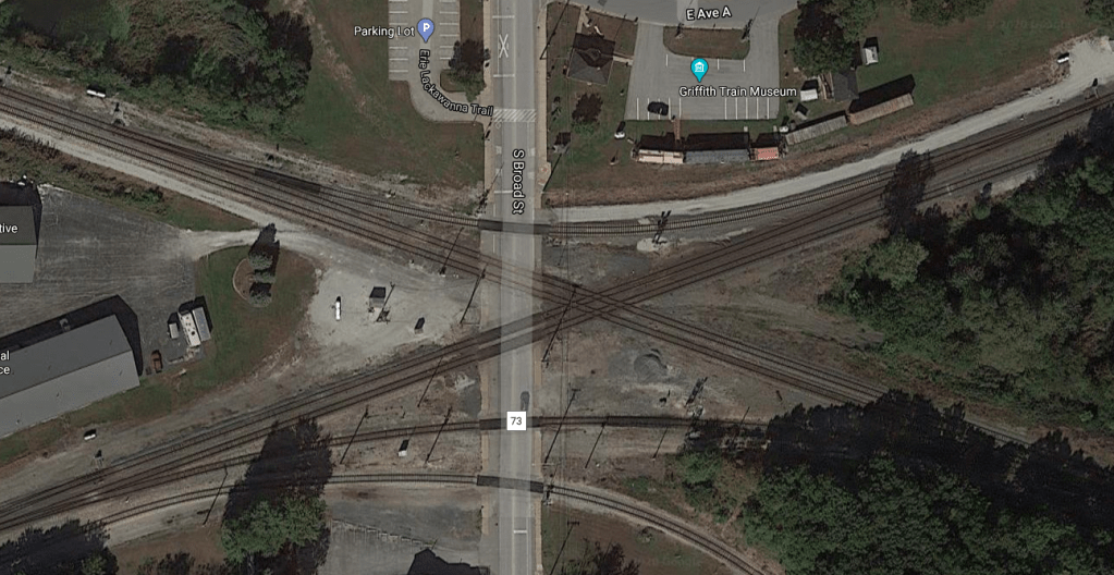
Recently, a picture was posted in the Indiana Transportation History Facebook group of a railroad crossing in Griffith, Indiana. Actually, it was three railroad crossings. In different directions. Across a street. That picture, as shared to the group by Randy Wilson, is available here. One of the comments to the picture was “what logic told to have all the tracks cross at that point?” You know, it’s a good question. But I want to focus on how they got there in the first place.

Google Map aerial photo of the Griffith, Indiana, rail crossings on South Broad Street. This image was snipped from Google Maps on 7 October 2020.

First of all, where and what is Griffith? Griffith is a town in Calumet Township, Lake County, Indiana. (Although as of 2020, the town was looking to legally remove itself from Calumet Township, moving either to St. John Township or North Township, both of which it borders.) The town itself claims to have been established in 1904. It had appeared on maps prior to that. It is in the Chicago Metropolitan area. As such, it became in the crosshairs of transportation facilities.

1900 USGS Topographic map of the Griffith, Indiana, area showing the railroads in the area.

The town came into being in 1880, with the completion in the area of the Grand Truck, shown on the map above as moving from east-southeast to west-northwest. The town’s very name, apparently, came from the surveyor of that section of the railroad, E. P. Griffith. That section of the Grand Trunk started life as the Chicago & State Line Extension Railway Company. This company was formed by the state of Indiana by law of 17 April 1879. By 8 September 1879, the Chicago & State Line Extension Railway had been consolidated into the Northwestern Grand Truck Railway Company. Between the two companies, 24 miles of railroad were built from Valparaiso to the Illinois-Indiana State line. This was, according to the Interstate Commerce Commission, was completed in 1880.

The Northwestern Grand Trunk would not last long, either. It would be consolidated with four other companies on 6 April 1880 to form the Chicago & Grand Trunk Railway. This would fall into receivership 3 January 1900, and be sold at foreclosure to the Indiana & Illinois Railway on 31 October 1900. 22 days later, it would become a part of the Grand Trunk Western Railway Company.

The Michigan Central rails through the area were also built by another company originally. But not one that would become part of the Michigan Central. Completed in 1854, 36 miles of track were constructed to connect Michigan City, Indiana, to the Illinois-Indiana State Line through the area that would become Griffith. This track was built by the New Albany and Salem Railroad. Yes, the same company that would later be known as the Monon. It would be acquired by the Michigan Central on 4 October 1878.

Two railroads that show up on that 1900 map that are hard to nail down are the Elgin, Joliet & Eastern Railway and the Erie. Both are well documented…but I always want to make sure that I have every bit of my information nailed down. ICC reports from both of these lines is sparse. I will be looking more into this.

1956 USGS Topographic map of the Griffith, Indiana, area.

Four years after the printing of the map above, the Chicago, Cincinnati & Louisville Railroad company completed a railroad track of almost 14 miles from Beatrice to Griffith. This track was completed on 7 February 1904. The railroad worked its way out of Griffith to the Illinois-Indiana State line, a total of just shy of eight miles, in October of the same year. The Chicago, Cincinnati & Louisville would be sold at foreclosure on 23 June 1910, becoming the Chesapeake & Ohio Railway Company of Indiana on 5 July 1910.

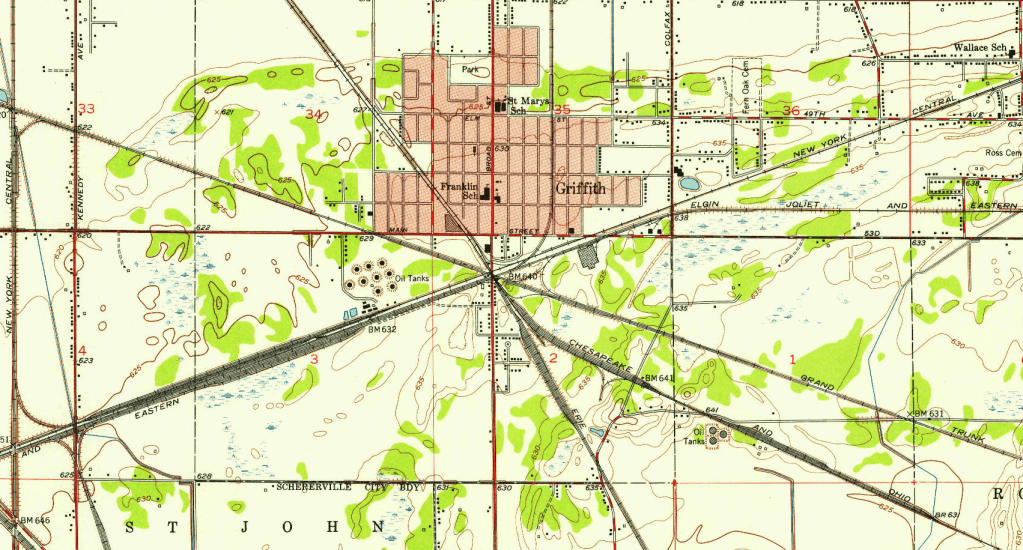
As shown in the above USGS map, Griffith became quite the railroad junction town by 1956. At that time, five rail companies would cross the town: New York Central (Michigan Central); Elgin, Joliet & Eastern; Chesapeake & Ohio; Grand Trunk; and the Erie. By 1968, the Erie would become part of the Erie-Lackawana, and the New York Central would merge with longtime rival Pennsylvania to form Penn Central.

The Grand Trunk Western had been a part of the Canadian National since 1923, when the Canadian government formed the Canadian National out of several properties that were consolidated and taken over by that government. In 1971, the Grand Trunk found itself more free of CN influence, as a new holding company was formed to contain the GT’s losses. This would last two decades, when the Canadian National would reassert its control over the GTW. The Canadian National would, 16 years after the reimaging of the GTW to CN, would purchase the Elgin, Joliet & Eastern. The CN would announce the purchase in 2007. On the first day of 2013, the EJ&E name was officially removed from being a corporate entity for (at least right now) good.

Below is a 1992 USGS Map of the area. It shows the old Michigan Central, EJ&E, Erie and C&O as old railroad grades.

1992 USGS topographic map of Griffith, Indiana.

More research is needed. But this is a brief overview of how a little town in a swampy area of Indiana became a railroad center.

SR 37 Indianapolis to Noblesville

When one looks at SR 37 northeast of Indianapolis, it is most often seen through the eyes of Interstate 69. And, honestly, I can understand that. But the current location of SR 37 through the area predates the interstate by at least 15 years. Looking through the history of the road, its purpose might not have been what I had always assumed. I know it was built to bypass Noblesville and Fishers. Let me explain.

Rumblings started when the state was planning to rebuild SR 37 through Fishers and Noblesville. This plan started in 1949. In 1950, it was reported that the citizens of Noblesville demanded a bypass of their city. At the time, SR 37 entered both Fishers and Noblesville along the old Fort Wayne (Allisonville) Road, and passed through Noblesville as Tenth Street. The traffic volumes along the state highway were getting higher and higher, especially in Noblesville. One plea came from Mrs. Alan Tener, representing the Parent-Teacher Association. She noted that “1,000 pupils attend three school buildings located on the present Ind. 37 in Noblesville. She said the Boy Scout traffic patrols have done an excellent job in preventing injury to the pupils, but that it is too great a responsibility for 11-year-olds.” (Source: Indianapolis News, 18 January 1950)

Flash forward to 26 April 1952, it was reported in the Indianapolis Star of that day that “Ind. 37 To Be 4-Lane; Gas Tax Hike ‘Needed’.” The Indiana State Highway Commission planned on making a four-lane limited access highway from Indianapolis to a point northeast of Noblesville. The entire plan consisted of, as reported by the Star, “12 miles of new construction in a Noblesville by-pass and 13 miles of reconstruction following the present highway in large part.” The cost, in 1952, was estimated to be $5,625,000.

But the limited amount of money from the gas tax was causing the ISHC to get behind on maintenance, let alone allow for new construction such as that on this project. It was estimated that the section of road between Noblesville and Indianapolis saw an average of 6,000 to 7,000 cars a day in 1952.

The new road plan called for “two one-way strips of pavement, each 24 feet wide, and 15 feet apart to a point about two miles north of Road 100” (then 82nd Street). “Then the division between the pavements will be widened to 30 feet.” The plan was for SR 37 to veer to the northeast from about three miles south of Noblesville, running 1.25 miles east of the city, and connecting in a straight line to the then current SR 37 northeast of Noblesville. The right of way would be between 120 and 150 feet wide through the project zone, requiring some property purchases.

This was after the State Highway Commission had stated in March 1952 that construction could be started that year. The proposed location was to be .25 east of the Hamilton County Home. This was the plan that Hamilton County government officials liked the best, as other surveys put the new road closer to the home.

Indianapolis News, 26 October 1955

Moving forward, the SR 37 bypass would have a contract bid date established: November 1955. But it wouldn’t for a complete bypass of Noblesville. The bid was to build a two lane bypass east of Noblesville starting at SR 32, working 2.6 miles north to connect to the then current SR 37. (It should be noted that two other projects were to be bid at this time, as well – two railroad underpasses on the Madison Avenue Expressway and the SR 46 bypass north and east of Bloomington.)

The results of the bidding for the project were announced on 22 November 1955. Grady Asphalt Inc., of Indianapolis, placed the low bid of $362,556.87 for the 2.6 mile section of new road. The engineering estimates at the time were $423,883.63.

The plan was, according to reports, to build the new SR 37 from the point 2.6 miles north of SR 32 to a point on Keystone Avenue, in Indianapolis, near 44th Street. According to the Tipton Daily Tribune of 17 September 1956, a detour at the northern end of the above let construction area would be in place for 30 days, forcing traffic along the “new” State Road 19 (which had been proposed and built when the proposal for the new SR 37 bypass was released) and into and through Tipton. The closure was due to the fact that the old SR 37 intersection with the new construction area was to be moved south to connect to the new SR 37 at a right angle. This required that one half mile of the old road be removed, and, according to the newspaper, the new intersection be moved south by one quarter mile.

After the first contract was let, the rest of the road’s contracts soon followed. This encouraged several articles in the Noblesville Ledger about pending rash of accidents that were soon to follow on this “excellent” road. Especially concerning was the intersection of SR 37 with SR 32/38. The original state plan was to allow SR 37 to be free flowing, with stop signs controlling the SR 32/38 multiplex. This was seen by the newspaper, Hamilton County government officials, and ordinary citizens in general as not one of the best ideas.

While the people of Noblesville demanded that SR 37 bypass their city due to traffic concerns, they weren’t exactly ready to give up a state road though there. After the completion of the new SR 37, the designation SR 37A was applied to the old SR 37 route along the Allisonville Road. That designation would last into the 1980’s before the state finally put its foot down to remove it from the ISHC maintenance list. More about that can be read in my article “SR 13/37 in Marion and Hamilton Counties.”

I covered the section of the bypass at Castleton in the article “SR 37/SR 100/I-69 at Castleton.”

Penn Central: 1962 Plans for a 1968 Merger

After World War II, two of the largest railroads in the Eastern United States were fighting for survival. Both had been hit hard by massively increased traffic and deferred maintenance during the war years. How each dealt with it, however, was a different story…and led to some very bad feelings over the years. Those railroads were the Pennsylvania and the New York Central. Bitter rivals, until they couldn’t afford to be anymore. Bitter acquaintances which caused them to afford it even less.

It all started in the 1950’s. Both railroads were floundering. They were, by far, the largest companies east of the Mississippi. The Pennsylvania, at one point, hired more people than the Federal Government. When rail traffic was dying after the war, and the Federal Government controlled what rail companies could charge, these two companies had two choices when it came to spending what little money they had: employees and maintenance. (There were more places to put money, yes, but these were the major two!) The New York Central, brought up to be a businessman’s railroad, tried their best to split these down the middle. The Pennsylvania, always known as a railroadman’s company, often erred on the side of the employees. This led to a shortage of cashflow, for the PRR, for the maintenance that was really needed. And this led to some major problems.

So the two railroads went out to find partners to help with the little thing called survival. The New York Central owned a big chunk of the Chesapeake & Ohio. The Pennsylvania owned a large share of the Norfolk & Western. All they needed was for the government to approve mergers along those lines. Which didn’t happen. As they scrambled for a way to survive, both companies realized that the only way to survive was to combine forces. Combining forces happened…the survival not so much.

But before the merger, the PRR/NYC management started working on joint projects in case the Interstate Commerce Commission should, at hearings in August 1962, seriously consider letting these two giants get together. One such project was proposed for the New York Central’s Big Four Yards in Avon.

The State of Indiana was important to both railroads. Those two companies, by far, were the largest railroads in the state, with the Pennsylvania being the bigger of the two. If the two were to go ahead together, it would certainly affect a lot of the state.

The Indianapolis News of 17 July 1962 described that the “officials of the New York Central and Pennsylvania Railroads announced plans here today to build a $4,285,000 diesel engine maintenance terminal at the Big Four freight yard in Avon.” The Avon yards, at that point, weren’t even two years old, having been dedicated on 15 September 1960. The News continued “construction of the terminal hinged on approval by the Interstate Commerce Commission of the proposed merger which has been requested by the two systems. ICC hearings on the merger proposal are scheduled for late August.”

The new repair facility would require three years to build, and would provide for the maintenance of 570 locomotives.

More cost-saving plans were announced at the meeting announcing the planned maintenance terminal. In the Indianapolis area, most of the measures would lean toward New York Central facilities.

First, a major expansion to the Big Four Yards in Avon. Since it was new, and one of the world’s largest and most modern railroad yards, it was decided that Avon would become the gateway to the southwest for the combined system’s freight.

Second, consolidation of passenger equipment maintenance would be done with the New York Central’s Beech Grove shops being the beneficiary. Most major repair of freight equipment would be moved to Hollidaysburg, Pennsylvania, to the Pennsylvania Railroad shops there. All major passenger equipment maintenance would move to Beech Grove.

Third, the Pennsylvania’s two major yard facilities in Indianapolis, Hawthorne and the Transfer Yards, would see major sections abandoned in an effort to save money on maintenance and taxes. Which leads to the fourth item on the NYC/PRR management list, availability of the abandoned facilities for industrial development.

Fifth, use of NYC’s Hill and west side yards, as well as the unabandoned portions of Hawthorne and Transfer, for freight service to support local industries.

And last, but not least, total removal of the Indianapolis Union Railway as a separate corporate entity. The IU owned trackage in and out of Union Station, the station itself, and the Indianapolis Belt Railway. However, due to the way that the Indianapolis Union was built, the Pennsylvania Railroad owned 60 percent of the company, with the other 40 percent being owned by the New York Central.

The railroad management stressed that potential job losses in the Indianapolis area, under this plan, would be around 256. It was also stressed that this compares to the 11,000 employees that have been laid off annually by both railroads over the previous decade. Also, the 256 employees would have job protection under the ICC plan. Those 110,000 people laid off previously had no job protections at all.

Ultimately, the New York Central/Pennsylvania merger would occur on 1 February 1968. The resulting company, Pennsylvania New York Central Transportation Company, or Penn Central, would stagger around for approximately two years before becoming the largest bankruptcy in the United States to that time. Avon would become the largest yard facility in the area. Hawthorne and the Transfer Yard would be scaled back. Beech Grove would take over passenger maintenance…and would go with the passenger service when Amtrak was created. The Pennsylvania’s east-west mainline through Indianapolis would be abandoned in favor of the New York Central’s.

And, ultimately, the company created out of the ashes of the Penn Central debacle, Conrail, would be split up among the two major eastern US railroads: CSX and Norfolk Southern. And when that split happened, the equipment of Conrail was marked to denote which equipment would go which direction. The letters NYC were used to denote equipment going to CSX, a descendant of the Chesapeake & Ohio. The letters PRR were used to mark that which was going to the Norfolk Southern, the descendant of the old Norfolk & Western.

Bloomington, 1910: Part 2

My last blog entry focused on getting in and out of Bloomington using maps from 1910. Today, obviously, is part two. Quick overview. Bloomington was a founded as the county seat in Monroe County, set in a location that was fairly accessible, and given a state university.

Historical Topographic Map Collection

First, I want to focus on the Bedford Pike, shown on the map to the left as the red line. Yes, by the name, it is obvious where this road was going when it left Bloomington. However, it was a continuation of the North Pike mentioned in Part One: the Paoli State Road.

Bedford was merely the next county seat on its way to the town of Paoli from Indianapolis. By the time the road had acquired the name “Pike,” toll road companies, or “turnpikes,” had carved the original road into many pieces. From Bloomington, those pieces included the North Pike and the Bedford Pike.

With the creation of the Indiana State Highway Commission, the road would fall into state possession in 1920 as State Road 22. With the Great Renumbering, it would become the original route of the much moved SR 37.

The Bedford Pike leaves Bloomington to the south using Rogers Street. South of the city, it connects to Walnut Street, which started life back south of Bloomington as the next subject road.

The blue line on this map shows the South Pike. Sections of this old turnpike to Chapel Hill have been moved and removed over the years. The South Pike starts on Walnut Street, but before it gets to Winslow Road, the old road turns to the southeast on what is now Walnut Pike, to carry over to what is now called Walnut Street Pike, the southern extension of Henderson Street. It follows this Pike to the end, where it turns east on what is now called Fairfax Road. The old road then travelled its way across the Monroe County landscape to Chapel Hill, an unincorporated community in the southeast corner of Monroe County.

Part of this old road is now completely gone. In 1960, the Army Corps of Engineers started damming Salt Creek to create Lake Monroe. This deluged part of the old South Pike near Fairfax Beach.

Historical Topographic Map Collection

Two other roads leaving the town of Bloomington at that time were the West Pike and the Rockport Road.

Although it starts heading southwest from Bloomington, the Rockport Road turns move southerly as it makes its way towards Springville. Today, the old road is still called Rockport, starting at the old Paoli State Road (Rogers Street).

The West Pike, the purple line on the map, leaves Bloomington to the west, on roughly the same route as what is now Bloomfield Road. The West Pike was part of the state road connecting Bloomington to Bloomfield. Today, it forms the basic route of what is now SR 45 to a point west of Stanford, an unincorporated community in Van Buren Township

The two railroads that connected Bloomington to the rest of the state were the Monon (actually, the Chicago, Indianapolis & Louisville) and the Indianapolis Southern (later Illinois Central).

The first railroad to town appeared as the New Albany & Salem, which had been completed between Salem and Crawfordsville in 1854, connecting Bloomington. Five years later, the name of the road was changed to the Louisville, New Albany & Chicago Railroad, to better show its expanse. As the road expanded, it acquired access to Indianapolis, but not from Bloomington directly. In 1897, the road changed its name to the Chicago, Indianapolis & Louisville.

Direct access, by rail, from Bloomington to Indianapolis was the Indianapolis Southern Railway. It was chartered in 1899 to build from Indianapolis south to Greene County. It would not be allowed to build in Indianapolis until 1902. The rail lie was completed in 1906 from Indianapolis, through Bloomington, to Effingham, Illinois. The Indianapolis Southern wasn’t a strong railroad, and had been loaned much money by the Illinois Central to complete the route. When the Indianapolis Southern fell into receivership, it became solely owned by the Illinois Central. This happened in 1911.

Today, the only railroad that serves Bloomington is the Indiana Railroad Company, the successor to that section of the Illinois Central. The Monon had been removed, as it was mostly duplicate routes to its successors: Louisville & Nashville; Seaboard Coast Lines; and CSX.

Bloomington, 1910: Part 1

While looking for older maps on the USGS TopoView website, I found one that really sparked my interest. One of the early towns in Indiana was Bloomington. It was established very early, and the college there, the state financed Indiana University, was also located there from the very beginning. Early descriptions of the place describe a pleasant town, with pleasant landscape, but without large quantities of non-poisonous water, or water at all.

But how did one get to to the town? If the state college was there, how did students reach it before all the roads became hard surface and passible all year round?

Historical Topographic Map Collection

This first map shows three major roads coming from Bloomington towards the west and northwest. Two of these are marked on this map as Pikes, or former toll roads.

Starting with the blue line, the Ellettsville Pike lead there…to Ellettsville. It was part of a bigger road that was the Bloomington-Spencer State Road built in the 1800’s. Today, it is called Arlington Road leaving the city of Bloomington. It would form the basic route of the original state road 32. This SR 32 would on 1 October 1926, become part of the new SR 46.

The red line leaving Bloomington, still called by the name listed on the 1910 map above, is the Vernal Pike. It led from Bloomington to the Vernal School, 5.5 miles west of the town, and with a branch to the Vernal Church, the same distance. The Vernal School was located near where Vernal Pike and Oard Road come together. The Vernal Church was on the northwest corner of what is now the intersection of Howard and Louden Roads west of Bloomington. At the school, the Vernal Pike turned southwest to connect with the green line on the map above.

The green line, now the basic route of what is now SR 48, is the Whitehall Road. It connected Bloomington to the town of Whitehall in Owen County, just across the Monroe-Owen County line. Whitehall is located at the intersection of Howard Road (mentioned above when it came to the Vernal Church) and SR 43, the current name given to the old Whitehall Road. Thus, there were three routes connecting the two towns of Bloomington and Whitehall.

Historical Topographic Map Collection

The next road I want to focus on comes north out of Bloomington. It is called the North Pike on this map, and was the road that leads to Martinsville. It was part of the larger Paoli State Road connecting Indianapolis to Paoli. It travelled through Martinsville and Waverly. It had many names between these points. At the northern end, it was called the Bluff Road. That was due to the fact that it connected Indianapolis to the Bluffs of the White River at Waverly.

From Waverly, it was called the Martinsville State Road, winding its way through the Hoosier landscape between the two towns.

From Martinsville, it did more winding on its way south to the Monroe County seat of Bloomington.

When it was added to the state highway system in 1919, it would be given the number State Road 22 between Martinsville and Bloomington. By 1923, the old connection from Martinsville to Indianapolis was given the same State Road 22 designation.

With the Great Renumbering of 1 October 1926, old State Road 22 would be changed to State Road 37. Over time, the section that is shown as the green line on this map would be bypassed several times. The route is now called Old State Road 37 after it leaves Bloomington proper, where it connected to the then SR 37 in Morgan County south of Martinsville. It no longer connects to SR 37 directly, as that road has been converted into Interstate 69 at the old connection point.

Due to a lack of resources, tracing to old paths east out of Bloomington is difficult using Topoview. However, what is now 10th Street in Bloomington would wind its way north and east from the city as the Unionville Road. This would later become part of SR 45. Third Street east out of town would wind its way through the hills of Monroe and Brown Counties, connecting to the Brown County seat of Nashville. This would later form the core of SR 46. It was originally (in 1923) part of State Road 26, which prior to 1923 only connected Columbus to Nashville.

In part 2, I will cover the three major roads that left Bloomington to the south. These are the Rockport Road, the Bedford Pike and the South Pike. I will also be mentioning the two railroads: one is the Chicago, Indianapolis & Louisville (known as the Monon) and the other is the Indianapolis Southern, which just started appearing on maps around 1910. The Indianapolis Southern would become the Illinois Central, and is now known as the Indiana Railroad.

The Old Louisville Road

In the early days of Indiana, and even pre-Indiana, transportation, there was a trail leading from the Falls of the Ohio, at New Albany, to a ford in the Wabash River at Vincennes. That trail, or most of it, was an old trace created not by man, but by bison. It was called, for most of its length, the Buffalo Trace.

I have covered it in a previous entry here on the Indiana Transportation History blog. Today, I want to cover the section east from Vincennes to Wheatland. I have found a couple of old USGS topographic maps that show the old road connecting the two labelled as “Old Louisville Road.”

When I did the “Road Trip 1926” series entry on US 50, available here, some people asked me about the location of the US 50 route from Vincennes to Wheatland. I placed it, according to what I could figure out from available state Official maps, north of the Baltimore & Ohio tracks. And that was the accurate placement. For 1926.

What is now called Wheatland Road was shown on old maps as the Old Louisville Road. The first two maps show the Old Louisville Road, still mostly dirt and mud, as it was in 1942. The yellow line is the old road.

That is the original route of the 1923 version of SR 5. When the Great Renumbering happened in 1926, it became the official route of US 50…for a short time. The state was already replacing SR 5/US 50 to track south of the railroad when the routes were renumbered. It wouldn’t be long before the new US 50, connecting Vincennes and Wheatland, would be in place…with a much better surface and straighter route.

The above map is from Wheatland west, showing the old Louisville Road before and after the connection with what would become SR 550. This map was published by the USGS in 1944. The old road swoops into Wheatland from the northwest, connecting to the new road at that town. But east of Wheatland, US 50 was the old road.

A road trip involving US 50 would be incomplete if one didn’t use the route above, as it was the original US 50. There is only one section that is impassible today, as it was ripped out when the Vincennes bypass was built. The below snippet from Google Maps, available directly here, show where the old road would cross the railroad tracks in a straight line from Washington Avenue to Old Wheatland Road. This was the jumping off point for the first move of US 50, with Washington Avenue turning more east and south.

I would love to share maps of the Vincennes end of the road. However, the first available from the USGS online is from 1965, after the bypass had been built. The 1915 map available covers too much territory to show anything, and the old road, and Vincennes, are pretty close to the edge of the map. And there is no map available east of that location for that early.

The 1942 map is available from Topoview at the following link: https://ngmdb.usgs.gov/ht-bin/tv_browse.pl?id=def30bcaf7088af1f2e39b12f87ff2bd.

The 1944 map can be found at this link: https://ngmdb.usgs.gov/ht-bin/tv_browse.pl?id=810cc3befc24241b312a2bbcfb66be68

US 31 Through Franklin

One of the hardest things to do as a researcher in transportation history is to put logic and active thought aside to deal with government plans. When I did the Road Trip 1926 series, I followed the maps issued by the Indiana State Highway Commission as close as possible. However, sometimes maps are unavailable, or worse, unknown to exist by me, so I end up making logical conclusions. Most of the time, this works out great. Other times, not so much.

Such is the case with US 31 through Franklin. When I did the “Road Trip 1926: US 31,” I naturally assumed that the original State Road 1 turned national highway went through Franklin following the old Madison State Road. It was, after all, the route that was used to make the highway. And it did.

A little research, and a knowledge of how the state works, and what I thought I knew needs a little tweaking. The Madison State Road came from Indianapolis and into Franklin along Main Street. It left Franklin to the south along State Street. A logical conclusion would be that State Street would be the old state road to Monroe Street, where it travelled Monroe to the courthouse. Here it got a little convoluted, since connecting Jefferson and Monroe Streets gets a little interesting.

But then I found a USGS topo map of Franklin from 1948. And the route of the old US 31 through the town became perfectly clear.

1948 USGS Topographic map of the US 31 bypass of Franklin, Indiana.

US 31 was such an important route that it was made a hard surface road very quickly. It was one of the first roads in Indiana to be made completely hard surface through the entire state. Because it was given such a treatment, it is easy to follow through Franklin, if you know where to look.

1948 USGS Topographic Map of the route of old US 31 through Franklin.

Armed with new information, I can now say, with more certainty, that the route of US 31 through the Johnson County seat came in from the north along Main Street. At Jefferson Street, it turned west to turn south on what is now West Court Street. (That street is now one way north.) West Court Street is only one block long, connecting Jefferson and Monroe Streets.

Here the old road returns to Main Street by going east on Monroe Street. Turning south on Main Street, the original US 31 travels until it reaches South Street. From here, it follows South Street east to the end of the road, which is State Street. South of this point was the original Madison State Road, and the route of US 31. To this day, it is still called Old US 31.

Then again, looking at the last snippet, I could still be wrong. A quick glance will show that there are three hard surface roads in Franklin. One is Jefferson Street from the courthouse west. That was SR 44 through Franklin. (SR 44 was decommissioned between SR 144 west of Franklin to I-65 east of the city.)

One is the route of US 31 as described above. The last one is Walnut Street from Main Street to Jefferson Street. It is entirely possible that this might have been part of US 31. I would doubt that to be the case. But it IS the point of this article to prove that I can be wrong occasionally when it comes to following roads through towns. Until access to more maps becomes available, or until things get back to semi-normal in the world, we will have to make do with what we can find online.

And keep searching, I will.

US 52 And the End Of SR 100

I have discussed numerous times that history of one of the most well known state roads in Indiana…State Road 100. If you would like to see the first post I did on the subject, check out “SR 100: How Did It Come To Be,” a blog entry that appeared on ITH on 9 March 2019.

But when exactly did Shadeland Avenue, the road still called Road 100 by mostly older locals, end being SR 100? And why did it just go away?

The answer stems from a very small inaccuracy that I made when it came to the state roads coming into Indianapolis. Indiana has a law on the books that only allows INDOT to carry an inventory of 12,000 miles of roads. When I say roads, basically anything that carries a state issued number is part of the system. When it comes to interstates, the ramps connecting the interstate to another street or road are also counted. I have mentioned it before…it leads to some very out of the way posted detours.

The inaccuracy came from when I mentioned US 52 on the southeast side of Marion County. US 52 was the first road that was removed from Indianapolis, and placed on the new Interstate 465 bypass. It was the first road that didn’t get into Indianapolis past I-465. But this isn’t entirely accurate. On the southeast side, the designation US 52 DID travel within the loop…but barely. When the bypass of US 52 was created, there was no direct connection between US 52 (Brookville Road) and I-465. Or, more to the point, there was only half a connection. For the US 52 bypass to work, Brookville Road continued to be US 52 until it reached SR 100, Shadeland Avenue, one half mile later.

1995 MapIndy aerial photo of US 52 and its connections to SR 100
and Interstate 465 on the east side of Marion County

This made the US 52 bypass use part of SR 100 in its route. As I-465 was completed, and legally replaced SR 100, the SR 100 designation started to be rolled back. In the early 1970’s, most of the route was given back to Indianapolis (which by that time covered the entire county). All of the signs marking SR 100 were removed. But the state still held on to the small section on the east side connecting I-465 to US 40 (Washington Street at the Cloverleaf). This remained legally SR 100, even though it was no longer marked as such.

Personal note here. As much as I have lived on the east side of Marion County in my life, I have never, other than on a map, actually ever seen a SR 100 sign. The closest I have come are the little blue reference markers that aren’t mileposts, but are numbered one mile apart most of the time. I have seen several times little blue signs with white lettering that read “SR 100.”

After a while, INDOT even stopped marking the Official Highway Maps with the designation SR 100. It still belonged to the state, but it was a shadow state road. Unless you knew it was SR 100, there was nothing telling you that it ever was.

Due to the way that I-465 was built, the US 52 bypass would travel around the south side of Marion County, until it reached the original I-465 connection to I-65 on the northwest side.

2001 MapIndy aerial photo of US 52 and its connections to I-465
and Shadeland Avenue on the east side of Marion County

On 1 July 1999, INDOT officially rerouted both US 31 and US 40 along the I-465 loop, decommissioning those two roads inside the bypass. Both would use the south and east legs of the loop. Because US 40 no longer existed between the two interchanges with I-465, SR 100 was officially decommissioned in its entirety from I-465 to US 40, removing the number 100 from the state inventory. The section from Brookville Road south to the interstate was still part of the state road system, as there still was no complete connection between US 52 and I-465.

By 2001, a connection from I-465 north to US 52 was completed, and the ramps connecting Brookville Road to Shadeland Avenue southbound were removed. This also led to a rather large reconstruction of both Shadeland Avenue and I-465 at this point, with the wide sweeping curves that had been present before completely removed. By the end of 2001, the ramp connecting Brookville Road to I-465 was completed, officially removing any section of all state roads inside the I-465 loop. It was also at this time that the official US 52 was routed north on I-465. Thus it traveled across the north side of the county, and along what became I-865 to Whitestown.

The official end of SR 100 was on 1 July 1999. But it was kept alive by the state for 20+ years, at least in part, due to the original plan of connecting US 52 to the bypass.

Winona Interurban

In the Interurban age in Indiana, there were light rail, or electric traction, trains going almost every direction one could think of. Today, I want to focus on what was called the Winona Interurban…a traction company that ran from Goshen to Peru. It’s history was brief…maybe a little over two decades. But it did serve a function. And it was well remembered years after its demise…and even had trains running on it into the 1960s.

Construction began on the proposed Warsaw & Goshen Interurban Company in 1904. The first meeting of the Board of Directors of the company was held at Winona Lake on 16 August 1904. Officers elected at that time include H. J. Heinz of Pittsburgh, Pennsylvania, as President, and a director from South Bend named J. M. Studebaker. The Warsaw & Goshen was to build between the two title cities, connecting, at Warsaw, to the Winona & Warsaw Interurban, allowing passengers to travel from Goshen to Winona Lake. The Indianapolis News of 26 August 1904 reported that “necessary surveys have already been completed, and work will commence within a few days. It is the expectation to have the road in running order by spring.”

One of the major concerns for the road is that the Winona Interurban was essentially owned by the Winona Assembly, the Presbyterian organization that also had extensive holdings at Winona Lake. That is how H. J. Heinz and John M. Studebaker were involved with the interurban project. Both of them, at different points in history, directed the Winona Assembly. This would lead to problems with the operation of the railroad in years to come.

The entire line went into operation in 1906.

As is typical of Indiana railroad history, the Winona Interurban found itself in financial trouble…and receivership. The Indianapolis News of 9 June 1908 reported that “a bill of complaint has been filed in the Federal Court by the Electrical Installation Company, with headquarters in Chicago, against the Winona Interurban Railway Company, the Winona Assembly and Summer Schools Association and the Winona & Warsaw Railway Company, in which it is asked, among other things, that the Winona Interurban Railway Company be ordered to operate its road every day in the week instead of only six, and that a receiver should be appointed.”

The suit was brought because the Electric Installation Company, as a contractor on the road, was given bonds in the route to the tune of $425,000. The EIC claims that the traction company made numerous statements that the route would be open on Sundays, but that it was never written in contracts “on the ground that such a clause might be objectionable to many of the stockholders and constituents of the Winona Assembly and Summer Schools Association.” This, the EIC felt, was too much of an earnings loss to bear. Due to the loss of what was believed to be 20% more income, the company was unable to pay any interest on the bonds over and above operating and maintenance costs since it opened in 1906. “Part of certain subsidies granted in Elkhart and Kosciusko counties has been used in the payment of interest.” The EIC also feels that the railroad will be unable to meet the interest payment due on 1 July 1908.

Due to the conflict of interest between the Winona Assembly and the Winona Interurban Railway Company, the EIC asked for a receiver to be put in place to allow for payment of approximately $30,000 in debt, payment of interest, and to allow the courts to remove the legally questionable ownership of the interurban line from the Winona Assembly.

Sunday service along the line was finally started in February 1909, the same time that it was announced that the railway was constructing a continuation of the line from Winona Lake to Peru, some 44 miles distant. The section from Winona Lake to Goshen was listed at 25 miles. An official of the Winona Interurban Railway Company, and Secretary and General Manager of the Winona Assembly Association, Dr. Sol C. Dickey, resigned his post with the railway due to the objection of running railroads on Sunday…something the Assembly had been against since the beginning.

The franchise creating the legal right to run the railway included Sunday service…although it was never enforced. The Indianapolis News of 19 February 1909 stated that it was never enforced due to “attention being called to the fact that it was impossible under the laws of Indiana to force any man to work on Sunday.”

The service on the Warsaw to Peru line, according to the same News article, would be opened to Mentone within a few days. That would cover 13 of the 44 miles between Warsaw and Peru.

The Winona Interurban Railway Company would find itself in a financial pickle when it was announced in December 1915 that the original bonds, called “Twenty year Five Per Cent First Mortgage Gold Bonds,” dated 1 July 1905, had fallen into default due to lack of interest payment on 1 October 1915, and the pending non-payment of interest on 1 January 1916.

By July 1916, the First Trust and Savings Bank of Chicago, having been the deposit organization for the bonds listed above, asked for a receiver to be appointed for the Winona Interurban Railway Company. The bank was the trustee for $750,000 worth of the above bonds issued for the Goshen Division of the line. The traction company, it is reported, defaulted on the payment of $37,500 of interest. Although the bonds were for the Goshen division (completed in 1905), a receiver is asked for the entire company, including the Peru division (completed in 1910). However, the Peru division was under the trusteeship of the Union Trust Company of Indianapolis.

Peru division bonds were $1.5 million of the allowed $3 to be issued. The Indianapolis Star of 23 July 1916 reports that John H. Holliday, founder of both the Indianapolis News and the Union Trust Company, had $50,000 personally invested in the traction company. “H. J. Heinz of Pittsburgh, the pickle king, has about $1,000,000 invested in the Winona Interurban. J. M. Studebaker of South Bend is another creditor, having over $100,000 invested.” (As an aside, 1916 is also the year Holliday gave his White River estate to the city of Indianapolis to create a 80 acre park.)

The Lafayette Journal & Courier of 15 December 1922 reported that the Winona Interurban Railway Company had filed notice, under a new Indiana state law, of its intention to surrender local franchises and permits. The company would then operate under an indeterminate permit under the jurisdiction of the Indiana Public Service Commission. These franchises and permits that were being surrendered included those in Goshen, Warsaw, Peru, Milford Junction, Leesburg and Mentone, as well as county franchises in Elkhart, Kosciusko, Fulton and Miami Counties.

It was reported in the Indianapolis Star of 25 May 1923 that the Winona Interurban Railway Company was, in fact, in possession of assets of about $3,000,000 with the road and equipment valued at about $2,300,000. The Winona & Warsaw Railroad, technically leased by the Winona, earned $8,000 a year in lease income. That lease, for 3.13 miles of trackage from Warsaw to the Winona Assembly, was for 99 years. Total earnings for the company came to $300,000 per year, at least according to the Star.

Reports in March 1924 were being floated that the Winona would be leased and controlled by the Interstate Public Service Company, the same outfit that owned the Greenwood line stretching from Indianapolis to Seymour and Louisville. The Winona line was inspected by people involved with the Interstate Public Service Company in mid-June 1924. The Winona was bid upon at a receivers sale in 1924. It had been in the hands of a receiver, former State Senator C. J. Munton of Kendallville, since 1916. The IPSC was controlled by Samuel Insull, a collector of interurban properties. In Indiana, he had come into possession of the interurban lines out of Indianapolis and Terre Haute, among other places, and consolidated them later into the Indiana Railroad Company.

Unlike most interurban lines in Indiana, the Winona would survive the end of the interurban era…barely. It had changed its name to the Winona Railroad Company in 1926, focusing more on freight than passengers. After a while, the company would drop passenger traffic from the rails, moving them to busses, in the mid to late 1930’s. Freight continued to be run along the line for many years.

The end of the company would occur on 15 June 1952. Abandonment was in order for several years prior to this point, but the Indiana Public Service Commission would not allow it until arrangements were made with the “steam’ railroads to take over freight service for the segment connecting Winona Lake to New Paris and the street running in Center Street in east Warsaw. Such arrangements were made with the Pennsylvania Railroad in early May 1952. Other sections had already been abandoned prior to this point. And thus, the Winona Railroad went away.

1917-1918: Indiana, Railroads and War

6 April 1917. The United States has entered World War I. And train traffic is about to become very heavy moving troops and material to the east coast to be shipped overseas. Indiana, being literally right in the middle of everything, would see the increase of that traffic first hand. And the decrease in traffic at the same time.

At the time, Indiana had six major routes crossing the state west to east: Baltimore & Ohio; Erie; New York Central/Big Four (including the Nickle Plate at that time); Pennsylvania; Southern; and Wabash. There were other railroads that were servicing the Hoosier state at the time to add into this massive amount of steel rail. Indiana had been very dependent on the railroads, to get people and freight in and out.

With the coming of World War I, and other things that happened around the same time, the lives of normal Hoosiers was about to be greatly affected. Even more so, to an extent, than the railroad people who had to do their best to supply them.

It all started with the war traffic itself. At first, there were few disruptions to the “normal.” Yes, traffic started to increase. Passenger trains were starting to be curtailed within a month of the entry of the United States into the war. The Baltimore & Ohio would be one road that was hit hard by the increasing traffic. That railroad announced in newspapers in mid May 1917 that passenger trains would be cut off to transport troops for the war effort. But, they said, it would be done to cause as little disruption to the civilian population as possible.

Another effect of the war on the railroads was simply the car shortage. This confuses people, since the idea is to take a railcar to its destination, empty it, and send it back for more loads. During World War I, this is not what happened…directly. Yes, the cars were loaded and sent east to the ports. And then they sat there, unable to be unloaded for up to months at a time. The cars would go east…and not come west for a long time, leading to a shortage of cars still trying to transport things east to go to the war.

Amidst the car shortages, coal strikes led to a shortage of coal loads to ship to the war effort. Or to the civilian population that used it to heat their houses. Many businesses would be closed several more days a week due to a shortage of heat producing coal. Towns throughout Indiana declared a day of the week as “heatless,” recommending that the public forego the use of coal on that day to extend the supply.

With the shortage of coal, and the shortage of cars to transport it, the Winter of 1917-1918 was going to be a long one. Then, it got worse. A blizzard tore across the northern part of the state in January 1918. The Indianapolis News of 28 January 1918 reports that Rochester, a city served by the Erie and the Nickle Plate roads at the time, had no traffic coming in and out of the town on that particular Monday. No new newspapers, visitors, or goods were able to get to Rochester. On top of “the observance of heatless Monday, made Rochester a dull place.” Such reports were coming in from all over the northern part of Indiana.

And with all of this going on, it was decided that the Federal Government would take over the railroads for the duration of the war in an effort to improve efficiency. This, as usual, had the opposite effect. Some of the backlog of cars would be broken up. But as Indiana’s freight started to back up for lack of transportation, the value of other forms of transport, other than the railroads, began to really come into view.

A lot of the reason for the a) downfall of the railroad and b) the major road system in Indiana can be solely laid at the feet of World War I. Not all of it, mind you. There were other factors at play. But it was World War I, and the constipation of the railroad system, that helped push Indiana into creating a State Highway Commission. While the ISHC was formed before the United States joined the war, the importance of such an organization came screaming out due to the war.

A Little Thinner

Today, I won’t be doing a blog entry about Indiana Transportation History. As ITH gets close to 500 entries, I want to explain why, if you haven’t noticed, entries are getting a little thinner around here.

First, as all of you are aware, it has been a very strange year. Most people were and/or still are locked away in their homes. This is not the case for me. I have been working this entire time. Early on, this was easy. As the “beer bug” continues, things on my end are getting back to normal. And when I say back to normal, I mean in the shortest time possible. I work in a big box retailer as a freight supervisor. The fact that stores have been out of things so much lately is now catching up as the supply system has been reset. What would normally be a three truck week this time of the year is a seven truck week.

Second. The majority of entries here comes from me having an idea, and investigating it. Nothing is ever set in stone around here. Usually, the idea leads in another direction as I find something that attracts my interest more, or most usually, something that has more information available. For instance, I STILL can’t find anything on the naming and termini of the Illinois Road out of Fort Wayne.

With the increase in work…and hours…mentioned above, ideas aren’t coming as quickly as they used to. I have been known to sit at my desk for a couple of hours before coming up with something to write about. That’s one of the reasons I keep asking what it is you, my readers, would like to see. Writing, normally, isn’t a problem. Starting is the problem.

Third. I have migrated to YouTube. A little…very little…of my time has been spent on my YouTube endeavors. Most of those include old time radio. And a new series rebroadcasting the news of World War II 81 years later. The real test is an eight hour show I do on Monday mornings (starting at 0100 EDT). And because of my love of history, I was asked to start a new channel…a history show with a guy from Winnipeg, Manitoba. None of this takes much of my time, but I can consider it a reason why things have been getting thin around here.

There are other things involved in all of this that I can’t discuss. Suffice it to say that I feel like I need to figure this out. I started this blog because of my love for both transportation and history. It’s not going anywhere. I was warned at the very beginning that I may hit a wall of subject matter. I thought that Indiana is 200 years old, and transportation has been around here longer than that…I’ll be fine.

Not quite. But I do feel that I owe my audience, you wonderful people that make this both possible and worth it, the truth about what is going on…and why things look a little thin around here. I will keep plugging away at this. This is my baby…I will not allow it to flounder.

The work situation will be getting better. The warehouses can’t be backlogged forever. Besides, I am moving to a different location…with roughly the same job…at the end of September 2020. That location is half the distance from my house. That will help quite a bit, as well.

My YouTube stuff, again, doesn’t take much time…and it helps clear my mind to see if another idea can take hold. I can’t tell you how many blog entries I have written while a video is running through its encode process over the past three months. Or when I am doing a live stream on someone else’s channel. Which I do quite a bit.

It may sound like I am running myself in a lot of directions. Yes…and no. I have to be always moving…always doing something. Usually, this creates a situation where ideas for many things come out.

I just wanted to take time to explain why things were kind of strange around here. It wasn’t until 0100 Friday morning that I realized I hadn’t written a blog for that day. Oops. So, please bare with me for the next several weeks. I promise it will get back to normal. Thank you for taking the time to spend with my ramblings over the past 18 months.

If you are interested, here is my YouTube channel… https://www.youtube.com/channel/UCtebwl4U4S5knOvmDOwNTgw. Keep in mind that the live streams, known as Short Attention Span Theatre, are entities of their own. And questionable content they are, I must say.

US 52 – Lebanon to Indianapolis

When the Lebanon bypass was in process in being construction, the state wanted federal money to expand the capacity of the road. The decision made by the state, and the requirements put in place by the federal government, was going to ensure that the route of US 52 between the county seat of Boone County and the state capitol would be in a different location.

I have covered before that the route of Interstate 65 at Lebanon was built before the interstate system was even created. It was originally built as a bypass of Lebanon of US 52. The bypass was under construction in 1955. The federal law creating the interstate system came into being in 1956.

The Indianapolis News of 23 June 1955 had the following headline “New Route for U.S. 52 Forced by Federal Aid.” It was simple…the feds demanded, if Indiana wanted half of the cost paid for by the feds, that there be a 300 foot right of way for the new bypass. Which, according to the News, “would take out houses on both sides if the existing road should be widened.”

1955 USGS Topographical Map of the then current US 52 south of the
new Lebanon bypass.

At the time of the article, the Lebanon bypass was half completed (two lane traffic). Interchanges were planned at SR 32 and SR 39. Since new highways classified as limited access, 11 businesses around Lebanon would not have access to the new bypass.

At the same time, the following roads were declared limited access: US 31 between Columbus and Indianapolis; US 52 between the Lebanon bypass and Lafayette bypass; US 52 Lebanon bypass; US 52 from Lafayette to Templeton; US 41 at Morocco; US 41 from the Kankakee River to Schnieder; US 31 at Jeffersonville to SR 131; intersection of US 40 and SR 100 on the east side of Marion County; US 27 south of Fort Wayne; US 24 and US 30 east of Fort Wayne; SR 46 at Bloomington (proposed bypass); US 420 (Tri-State Highway) in Lake County; US 31 north of Uniontown; US 31 on Madison from Southern to Delaware, Indianapolis; SR 37 from Keystone to point north of Noblesville (proposed new Indianapolis-Noblesville highway).

Moving Railroad Tracks In Muncie

When rumbling through transportation history, its hard to miss the elephant in the room that is the railroads versus highways debate. And how that was mostly won by highways. And one would not be blamed for blaming that loss on the coming of the interstate highways. For years, that is what I thought. However, what appears on the surface is not always the right answer.

Since the federal government started pumping money into state highway programs in the mid-1910’s, state and local governments have been trying to find a happy medium between efficiency and the want to have every highway possible. As the call for safer and more capacity highways grew, the governments involved finally realized something that should have been completely obvious from the beginning…the railroads were there first.

And state and local governments had their hands tied. Railroads were privately owned organizations. Most of the time the same governments that wanted them to move or just go away were the ones that gave the land to build there in the first place. Unlike roads, which were getting basically a reboot at the beginning of the twentieth century, railroads were in place. With very few exceptions, they hadn’t changed much, in routing, in the 20th century. There were new lines being recommended, but very few new lines came into being after around 1900.

Then, in July 1947, an Indiana Congressman decided to introduce a bill to the U. S. House of Representatives that would help out the local governments when it came to those pesky railroads. The legislation, introduced by Congressman George Gillie, would give cities the right to require rerouting of railroads when their location was seen as a hazard to the federal highway.

Newspaper reports, especially from the Muncie Star Press of 11 July 1947, roughly detail the plan. It was covered in Muncie since that city, as well as Fort Wayne, would most likely be the beneficiaries of such legislation in Indiana.

“The bill was introduced by Representative Gillie would authorize municipalities to reroute railroads in such a manner as to eliminate a declared hazard provided the municipality first obtained from federal and state authorities a declaration that public safety would be served by railroad relocation.”

Covering the same bill, the Indianapolis Star of 10 July 1947 mentions that “Congressman Gillie’s office said the bill was intended to apply to the present routing of the Nickel Plate Railroad through Fort Wayne, the congressman’s home city.” It went on to mention that “grade crossings on the Nickel Plate’s line now affect main highway traffic through the city of Fort Wayne. A relocation project for the railroad has been in dispute for several years.”

1953 USGS Topographic Map of Muncie with the original
Nickel Plate Fort Wayne line highlighted.

Muncie had the same problem with the same railroad. The location of the Nickel Plate tracks on Madison Street, which had become, or soon would become, the routing of US 35, SR 3 and SR 67 through the city. This stemmed from the fact that the Nickel Plate line north out of Muncie to Fort Wayne ran right down the middle of Madison Street before turning slightly northeast to head out of Delaware County. The giant curve of track south of White River and McCullough Park actually entered a railroad yard on the southside of White River, through which the Chesapeake & Ohio and the Pennsylvania traveled. It would be later reconfigured to carry the Muncie-Fort Wayne mainline off of Madison Street.

The diamond that allows the Nickel Plate to cross the Bee Line, a location I have spent many a day watching trains with my friend, actually allowed the Nickel Plate to continue across its own track (the track running more east and west) and curve its way onto Madison Street. Map evidence shows that the track was gone from Madison Street by 1962.

Whether the legislation got passed or not, it is clear that the railroads were affected directly by plans of the same ilk. Muncie removed its Nickel Plate tracks from the state road. The state later removed the state road from Muncie.

Indianapolis’ Mile Square

A discussion in a Facebook group the other day got me to thinking about the original mile square that was the town of Indianapolis. Now, this topic may seem to venture a lot closer to history and really far from transportation. And mostly, I would agree with you. But today, this focuses on the “map” that someone found of Indianapolis in 1821…and the streets that actually happened.

It started with the “map” above. Someone had commented about Google Maps not having historic maps, and that they would love to see a map of Indianapolis when it appeared like this. There were many great comments about this…and how great the lay out of the town was. But it bothered me.

A map of Indianapolis never actually looked like this. Ever. The image above shows the original ideas of Alexander Ralston for the town. Also, keep in mind that Mr. Ralston only used one square mile…out of the four he was allowed…because he never thought the town would get any bigger. It was, after all, an swampy outpost in the middle of a forest.

Back to the map, and the comments. Someone had mentioned that Indianapolis is one of the most symmetric cities ever built. I had to disagree with that person on that opinion, given the location of Pogue’s Run.

When the town of Indianapolis was actually built, the streets surrounding Pogues Run were never created. Those streets (North Carolina, South Carolina, and Short) were left off of the map of the town. Instead, as shown in the 1831 map of Indianapolis below, the north-south streets were continued across the creek that would be a pain in the neck for the Hoosier capitol for almost 100 years…until it was buried.

This is just a portion of the map. And even then, I am skeptical. This image has a production date of 1906. But I am more apt to believe this one, because I have actually seen other maps within a decade or two of what date it’s supposed to be. Those maps show the same thing – Pennsylvania, Delaware, Alabama and New Jersey continue across Pogues Run.

Another difference between the 1821 plat and the 1831 map is the names of the streets around the Mile Square. Or, more to the point, the INCLUSION of those streets. On Alexander Ralston’s original plat, the streets of the town just dump into the wilderness. There are no North, South, East and West Streets. They weren’t included.

By 1831, the town had overrun the mile square. And, hence, street names were added to the edge of the original area of the Hoosier capitol.

As an aside, it is possible, using the plat of Indianapolis, to prove that 10 times 10 is 101. Look at the last platted square on both maps.

The supposed symmetry of the town was disrupted by Pogues Run. It actually got closer to symmetrical when the Carolinas and Short Street were left out. But the whole idea of symmetry went straight out the window with the very first addition to the town. And it continued from there.

Bus Service At the End of the Interurban Era

As the electric traction, or interurban, trains ran across Indiana, they provided a service that many Hoosiers took for granted. The interurban covered much of the state, allowing passengers to get almost anywhere. Some companies grew very large from the consolidation of the interurban cars and the street railways in the cities. Union Traction, the company that provided service from Indianapolis to Fort Wayne, via Fort Harrison, Anderson, Muncie and Marion, actually owned the city street railway in Muncie…among others. The same company that owned a majority of the traction routes out of Indianapolis also owned the city trolley cars lines in both Indianapolis and Terre Haute.

The problem was, the writing was on the wall.

Part of what made the interurbans possible was the fact that the companies made their own electricity…and sold it to people along the line. The company that owned the Greenwood line was called Interstate Public Service. When the Federal Government required the power companies and the traction companies to become separate entities, the barely money making trains became anchors around the necks of the companies left to take care of them. Interstate Public Service changed the name of its power company to Public Service Indiana.

But the transportation service was still vital to the residents of Indiana. Or it least it was through the 1930’s and 1940’s. Something had to be done to make sure that people could get around the state, and through the cities, but still not spend a ton of losing money on the proposition. And soon, the electric traction train cars were replaced with diesel bus service in many places.

Indianapolis was known, at the time, for having the largest Traction Terminal in the world. But by 1926, part of it had already become known at the Traction Terminal Bus Station. Interurban trolley cars and buses were already using the same facility by 1926…half a decade before the train cars started disappearing from the landscape of the Hoosier state.

By that time, most of the interurban companies were already running charter bus services. As the advertisement to the left shows, the Interstate Public Service Company was running chartered bus service. This ad is from the Indianapolis Star of 5 June 1926. One of the Interstate Public Service excursions included bus service to Brown County. The round trip was $3.00. And you could add a chicken dinner in Brown County Park for $1.00.

Union Traction, mentioned above, ran a bus from Indianapolis to Turkey Run every Sunday. It left the Traction Terminal Bus Station at 0700, arriving at the park at 1000. Its return trip was completed at 2200 Sunday night when it arrived back at the Traction Terminal.

In 1932, the Indiana Railroad Company, owner of most of the traction lines radiating out of Indianapolis (they leased the interurban companies…the biggest of which was the Terre Haute, Indianapolis & Eastern, owner of a lot of interurban tracks and city services), decided to call an end to the tracked interurban rail service from Indianapolis to Dunreith. That service supported Greenfield. The government of Greenfield found itself suing the traction company for continuation of service. But there was service. The Indiana Railroad had replaced the traction cars with bus service provided by the Indiana Motor Transit Company. Yes, the Indiana Transit Company was owned by the Indiana Railroad. But that bus company continued service from Indianapolis to Dunreith, where it met the interurban train making the Richmond-New Castle-Indianapolis run. Starting on 6 January 1932, that bus service ran twelve trips, each way, daily. Busses left Indianapolis at 0800, 0915, 1245, 1430, 1600, 1645, 1715, 1740, 1810, 2015 and 2315.

But it still wasn’t all rainbows and unicorns for the transit companies. Even with the use of busses, the companies were still losing tons of money during the 1930’s. The Great Depression raged on throughout the decade…and slight money makers in good times were absolute money losers in bad. And with the exception of rural people trying to get to shopping in the urban area, a lot of the traffic had been curtailed as non-essential.

Busses would completely replace the Indianapolis-Anderson-Muncie-Marion-Fort Wayne line on 18 January 1941. The last of the Indiana Railroad traction cars would run that night, making the final run of the interurban line. The traction cars started running through Muncie in 1900 as the Union Traction Company. In 1930, it became part of the Indiana Railroad.

But busses weren’t the only thing that replaced the traction cars. There was still quite a bit of small freight running along the electric traction lines. This service was replaced with trucks. The bus service along the Union Traction line was maintained for Lawrence, McCordsville, Ingals, Pendleton, Anderson, Muncie, Chesterfield, Daleville, Yorktown, Royerton, Hartford City, Montpelier, Fiat, Nottingham, Petroleum, Reiffsburg, Bluffton, Ossian and Fort Wayne. Service from Muncie to New Castle included Cowan, Oakville, Springport, and Mount Summit. Fort Harrison, Fortville, Shideler and Eaton were also added to the old Union Traction line bus service.

The interurban companies all found their way into providing bus service. And these busses, like the train cars before them, fanned out across the state providing passengers and freight a way to get from point a to point b. But just like the interurbans before them, the busses found themselves on the way out. Reducing ridership suffered by both the interurban bus services and the steam railroads led to an end of the majority of those services. The day of twelve busses a day moving along the National Road between Indianapolis and Richmond would be gone. First, the numbers of bus trips went down daily. Then it became a weekly trip. Then the bus company just gave up and ended the trips all together. Hoosiers were using far more cars than ever, making busses unprofitable or even impossible to run.

Let’s Share…

Today’s Indiana Transportation History blog will be a short one. And not much information. But there is a method to my madness.

I have, sometimes, hundreds of readers. And you all have come to ITH for one reason or another. Most are interested in history. Some are road geeks. Some are railfans. I happen to be all of the above.

What I want to know is this…what is something in your area that you find intriguing, puzzling, interesting, etc., about Indiana Transportation History? What would you like to share with the ITH community about your neck of the woods. And even if it isn’t about Indiana, there has to be a reason you are interested in this subject that is specifically Indiana.

Other than the topics that I have covered over the past 18 months, two that hit home for me lately are the sheer emptiness of the Hoosier landscape and the concept of a shunpike.

The City of Indianapolis has been doing construction on German Church Road. For the first two weeks, we were unable to use the road southbound. This made for an interesting detour either down Mitthoeffer Road or Muessing Road to Prospect Street, then back up German Church to my subdivision which is 3/10 of a mile south of Washington Street…aka where German Church was closed.

For the next four weeks, German Church was closed northbound, which meant getting to shopping…aka Walmart or Meijer…took as long to drive to as it does for me to walk there. Literally.

I realize that there were nothing but farms out here…thus creating a detour of over four miles to get to a point that is 1.5 miles away. I joked with some friends on YouTube that I wanted a roast beef sandwich, but wasn’t driving five miles to get one when I can walk 1/2 a mile to the same Arby’s restaurant.

The other idea that I may someday figure out how to flesh out to a full entry is the concept of the Shunpike. For those that are not familiar with the term, back in the 1840’s through 1890’s, most major roads in Indiana were owned by toll road companies. Along the way, locals built roads that roughly paralleled the toll roads, if they could, to avoid paying the toll.

That brings me back to Prospect Street and my four mile detour. Most people don’t know this, but it is possible to get from Irvington to Greenfield using two old paths. The most direct (duh) way was the National Road. It still is. However, if you wanted to avoid the tolls, starting at what is now Arlington Avenue, you can travel east on what is now English Avenue/Rawles Avenue to either Post or Mitthoeffer Roads, turn south, and take Prospect Street all the way to SR 9 south of Greenfield. (Although my bet is that the road into Greenfield itself involved what is now Franklin Street.)

Using this circuitous route, travelers could get from Irvington to Greenfield without paying a toll. Turning left on Franklin Street, and traveling one mile north, then turning right, it was possible to get as far as Knightstown without paying a toll.

There are many such roads all over the state. I chose that one because, well, it is at the end of the block from me…if you took out all the streets added by the subdivisions built over the last 30 years. My back fence is on the survey line that is halfway between the correction line at what is now 10th Street and the survey line that makes the center of Prospect Street.

So….what I am asking from you is to share what you find interesting in your area. Maybe there is someone in your area that has the same interests or questions? Who knows, maybe we can come up with a subject for a new blog entry?

And I am always a fan of audience interaction. I now run a YouTube channel…and the first rule that I have always lived by is “know the audience.” I would like to know a little more about you folks that make this a labor of love for me…and have since February 2019. Almost 500 entries ago.

Planning I-465…and Arguments

When the planning for Interstate 465 was underway, to say that it was a bit contentious can be, at times, an understatement. This was especially true on the east and north sides of the loop. Most arguments made against the plan of the interstate were legal in nature. One actually turned violent.

The first discussion that I found involved arguments of the legal kind involving the northern leg of 465. An injunction was sought to stop further public discussions concerning the building of the road. The court proceedings were in May 1961. Arthur H. Gemmer, attorney, represented some 40 people against the interstate, and its construction near 96th Street. The argument was that the State Highway Commission broke a 1945 state statute by not consulting county and city officials as to the location of the road.

The remonstrators wanted to halt hearings on the proposed route until the Bureau of Public Roads could rule on the appeal they filed about the location. The court hearing was simply for an injunction to stop the hearings, because the court in question did not have jurisdiction over the road proposals. The remonstrators hoped, in the end, that the interstate would be pushed further north into Hamilton County, as opposed to the 96th Street corridor as originally designed (and later built).

Two months later, on 13 July 1961, the same remonstrators were involved in an actual violent argument at North Central High School at an I-465 planning meeting. The meeting was already advertised as not going to be turned into a legal battleground. That didn’t stop an attorney to attempt introducing legal briefs into the meeting.

The leader of the meeting, Oral S. Craig of the State Highway Department, told the attorney to be seated, and a number of the 400 people at the meeting started shouting angrily.

Especially contentious was the area around Spring Mill Road and the proposed highway. One man, a Stanley Valinet, contended that plans for a $2.5 million shopping center at the corner of Spring Mill Road and 96th Street had been approved two years prior. Part of that land would be part of the plan for a cloverleaf interchange at US 31 and I-465. The state argued that the “construction” of the shopping center only started after publication of the proposed routes, and that the entire construction to that point involved several sections of concrete block foundation.

At that meeting, it was pointed out that “Line E,” or the proposed preferred alternative, involved removing 66 homes from Shadeland Avenue to Boone County. The “Line D” proposal would have taken out 83 homes in the same distance.

Indianapolis News, 6 July 1960, showing the chosen preferred route of Interstate 465 on the north side, and two of the abandoned choices. (Also note the “Proposed Ind. 100” running north and south west of Zionsville Road.)

The last discussion about the proposed I-465 involved the east side location of the road. The Warren Civic Association made an appointment to meet with state highway officials on 13 September 1961. The meeting was to try to convince those officials to move the proposed route of I-465 three miles to the east. State and Federal officials had already approved the location of the road, but construction would be in a holding pattern until the location of the northern leg of the highway was settled.

Part of the issue were 14 homes that were built in the proposed path of the interstate…after the plans for the route were announced. Each of those homes cost approximately $30,000. “The state of Indiana is going to pay through the nose,” stated Lloyd C. Fleetwood, Warren Civic Association Vice President.

Moving the route three miles to the east would eliminate the need to tear down a residential area, as there was no such thing further east. Such a location would have put the interstate at or near Cumberland. But officials at both the state and federal levels had already, repeatedly, ruled against the proposal. It didn’t stop them from trying, however.

There were more “discussions” concerning the locations and designs of I-465. Especially contentious was the 21st Street grade crossing on the west side of Marion County. The north leg would be the hardest part to get built, as from proposal decision to completion took almost a decade.

Early State Roads

An oft-heard claim when I am out an about is that the Michigan Road was Indiana’s first state road. While I will never deny the importance of that road (heck, my job is on the Michigan Road in Hamilton County, and I use the section in Shelby County quite a bit to visit the in-laws), it is not, by far, the first. It was the first to connect the state from north to south, but not the first in general.

The National Road, in its importance as well, was finished before the Michigan Road. And even then, the National Road was preceded by a less known road called the Centerville State Road. When the National Road came into being, any reference to the older state road became lost to history. I covered that road here: The Tail of Two Roads: National Road and Centerville State Road.

But the idea of state roads in early Indiana was completely different that it is today. Any look at newspapers of the late 1820’s through the late 1830’s would show a long list of state roads spanning the state in all kinds of directions for all kinds of purposes. A common criticism of the state road “program,” such as it was, in the early days is that the state would build a road to a specific person’s land, or ferry, or whatever. If it was politically expedient to build to Miller’s Ferry over the Smallerthana River, such a road was built. Or, more to the point, financed to be built.

There was no central authority when it came to state roads in that era. As a matter of fact, those early roads financed by the state were actually passed into law by the General Assembly. So the vast system of roads that were financed by state money, the very definition of a state road in the early days, had to have majority approval to be constructed. So the very notion of political favors became very important if Mr. Miller wanted to get some state money to connect his ferry over the Smallerthana to the towns of Widespot and Tensalloons on either side.

A lot of the early state roads, however, did serve the governments of the state and counties. Many roads were financed that would connect county seats to one another, or to Indianapolis (technically a county seat, as well). The above mentioned Centerville Road was built from Indianapolis to the then county seat of Wayne County…Centerville (or, as it was originally, Centreville). Richmond, at that time, was a just a town close to the Ohio State line on the Whitewater River.

As the state grew, the state roads that had originally been built to service the county seats no longer did so in some cases. In the article The National Road, and County Seats, I mentioned that when the National Road was surveyed, it connected three county seats of the eight counties it traversed: Wayne County (Centerville); Marion County (Indianapolis); and Vigo County (Terre Haute). Two would be added later. First would be Greenfield (Hancock County), platted specifically on the National Road. Next would be Brazil (Clay County), which would become the county seat after having been moved from Bowling Green.

As the state capital, Indianapolis had more than its share of state roads emanating from it. In a circle starting at the north, Indianapolis had the Westfield State Road, Fort Wayne State Road (Allisonville Road), Pendleton State Road, National Road (Washington Street), Brookville State Road, Michigan Road (Southeastern Avenue), Shelbyville State Road, Madison State Road, Leavenworth State Road (Meridian Street), Paoli State Road (Bluff Road), Mooresville State Road, National Road (again), Rockville State Road, Danville State Road (10th Street), Crawfordsville State Road, and the Lafayette State Road. That doesn’t include several that cross through Marion County without actually going to Indianapolis. The one that comes to mind is the Noblesville-Franklin State Road (Franklin Road), which would connect the two title towns via Fenton, Lanesville, Lawrence and Fisher’s Station.

And here the other major difference in early state roads and the modern variety comes screaming into the spotlight. When the state General Assembly approved a road, the financing was done by the state. The road wouldn’t belong to the state. As soon as construction was complete, the state would turn the road over to the county. If it was to be maintained, the county was responsible for it, not the state. The major reason that turnpikes and toll roads came into being at all was due to the fact that the counties had “state roads” going every which direction, sometimes for no appreciable reason, that the County Commissioners were responsible for keeping passable. Honestly, most counties failed in this. Hence, sell the road, let someone else take care of it, and the county gets an influx of cash they don’t have to spend on roads.

One last point. The words “state road construction” gives the impression that there were actually roads built. This was mostly not true. The state would spend the money to improve the road, not (usually) build a new facility. A quick glance at any map of Indiana, even todays, show a bunch of roads that start, run for a while, turn for no apparent reason, run some more, and just appear to end in the middle of nowhere. Two examples that come to mind from the Indianapolis area are the Shelbyville Road and the Mooresville Road.

The latter would become the route for SR 22 in 1917, and SR 67 in 1926. A look at the twists and turns in that road would give anyone a good idea why there has been a LOT of moving around of SR 67 over the past 100 years. The former leaves Marion County as Shelbyville Road, then just ends in eastern Johnson County. Or, at least as it is marked. I have been trying to trace the old state road from Indianapolis to Shelbyville. In Indianapolis, it starts as Shelby Street. In Shelbyville, it starts as Boggsville Road. In between, it gets really kind of fun.

But this was due to the fact that Indiana really only built, from scratch, one state road. Most were improvements county roads that were already in place. That one state road that Indiana had built brings us back to the start of this article: The Michigan Road. The state did build that one from scratch. In that case, I guess that DOES make the Michigan Road the first state road in Indiana. It all comes down to semantics. It doesn’t really matter in the end. With the creation of the Indiana State Highway Commission in 1917, the concept of the state road would change. And most of the Michigan Road would ultimately, once again, become a state road.

October 1979. The End of A Railroad Era

Looking back through the history of Indiana, and Indianapolis in particular, it is hard to have an opinion other than one simple premise: the railroad built the Hoosier State and its capital. Now hear me out. There were people coming into the state by the roads and rivers. I can’t deny that. But the numbers of people that were coming increased drastically when the railroads began their journeys across the state. Think about it, in the year 1847, when the first railroad entered Indianapolis, the state capital had officially become big enough to legally change from a town to a city.

But what comes around, goes around. Fast forward to 1 May 1971. The new government railroad company, Amtrak, started operations as the major passenger train company. Not all railroads gave up their passenger operations to Amtrak in the beginning. Some railroads wanted to give it a go, continuing their passenger service. That, however, did not last long.

The passenger service in the United States continued to stumble along as Amtrak tried to find its footing. Eight years later, the company decided to shed some of its dead weight.

Indianapolis, a city that at one point had 200+ trains daily stopping at Union Station, by 1971, had dropped to two: the James Whitcomb Riley and the National Limited. The National Limited, as it was called then, was actually the continuation of the Pennsylvania Railroad’s Spirit of St. Louis, connecting New York to Kansas City. The original National Limited was actually a Baltimore & Ohio train connecting Washington, DC, to St. Louis. That train ceased operations on 30 April 1971, the day before the Amtrak takeover.

Another train that rumbled through the Hoosier landscape was the Floridian, carrying passengers from Chicago to Miami. It had two regular stops in Indiana during the 1970’s: Lafayette and Bloomington. Hence, Lafayette had the service of two regular trains through the 1970’s: James Whitcomb Riley and Floridian.

As I mentioned yesterday, the James Whitcomb Riley had its route changed due to track issues between Chicago and Louisville along the Penn Central. By 1974, the number of passenger trains serving Indianapolis had dropped to one: National Limited. And even that was questionable just a year prior.

A plan by the National Railroad Passenger Corporation (the official name of Amtrak) was to eliminate their trains numbered 30, 31, 52 and 53 on 2 August 1973. In Amtrak parlance, trains 30 and 31 were the National Limited. Trains 52 and 53 were the Floridian. Opposition to this plan was found in the government officials all along the two rail routes. Mayor Richard Lugar of Indianapolis issued a statement on 12 July 1973 stating just that. The expectation was that Indiana Governor Otis Bowen would issue a statement along the same lines within days.

Protests to the pending removal of these railroad lines was due to be in Washington, DC, by 18 July 1973. Other protests came from the United Transportation Union, the union that represented Amtrak employees.

The railroad routes were saved. For the time being. 1974 saw, as mentioned above, the necessary, and supposedly temporary, rerouting of the James Whitcomb Riley. Richmond would be the benefactor in this arrangement, as now that city had more passenger service than did Indianapolis. (And, yes, I do not the irony in that passenger service to Richmond was provided by the same trains that had provided Indianapolis with it.) Now, instead of Indianapolis, the James Whitcomb Riley and the National Limited had stops in Richmond.

Fast forward to the summer of 1979. Amtrak is planning cuts again to both the National Limited and the Floridian. And, again, the protests started. It even led to a Court of Appeals in Washington, DC, to issue a temporary restraining order directing Amtrak to maintain the National Limited past the proposed 30 September 1979 end date to at least 12 October. That was shot down when Amtrak appealed to the United States Supreme Court. The Supreme Court would snuff out the restraining order, allowing the National Limited to leave Penn Station in New York at 1555, 30 September 1979.

When it stopped at Indianapolis, it would be the last train to use the grand old Union Station after 90 years of service to the city. The last train to serve the station would be the eastbound run of the National Limited, which, ironically, would be running late.

The Floridian last a bit longer. A judge in Wichita, Kansas, ordered Amtrak to keep three of its lines operating. These included the Lone Star, the North Coast Hiawatha, and the Floridian. All three of these trains served Chicago. The Lone Star went to Houston. North Coast Hiawatha served cities and towns between Chicago and Seattle. As mentioned above, the Floridian rumbled its way through Lafayette and Bloomington on its way to places warm and sunny.

The reprieve would not last long. The Floridian had been operating on a day-to-day basis since the original 30 September 1979 end date. That extension would last about two weeks.

There was talk, especially in Richmond, of restoring the National Limited. Talks of Penn Central/Conrail abandoning the old Panhandle main line connecting Richmond and Terre Haute via Indianapolis did not quell the talk. The National Limited could simply be rerouted toward the Bee Line out of Richmond, and still connect Indianapolis and Terre Haute on its way west. The Panhandle was abandoned in 1982 and 1984. And the National Limited never saw its revival.

And Indianapolis Union Station would be just short of its 100th anniversary (keeping in mind that before 1888, and the current station was built, it was known as Indianapolis Union Depot) before it would see another passenger locomotive grace its portals. And that was the return of the train that had been the James Whitcomb Riley.

The “James Whitcomb Riley” and the “Cardinal”

28 April 1941. The New York Central inaugurates a new passenger train to connect Chicago, Lafayette, Indianapolis and Cincinnati. That train was given the name “James Whitcomb Riley.” The equipment used on the new train had recently been completed at Beech Grove, the shop facilities of the New York Central. The railroad decided that the Hoosier poet was an appropriate name for a route that would use the latest in streamlined equipment.

The “press run” of the Riley was made on 23 April 1941. Leaving Chicago mid-morning, it arrived in Indianapolis at 1130. With the exception of slowing down at Shelbyville, Greensburg, and Batesville, the train didn’t stop between Indianapolis and Cincinnati. The return to Indianapolis was provided by the “Sycamore,” another modern Big Four route without the streamlining of the Riley. The Riley would start service five days later, leaving Cincinnati in the morning, and returning that evening.

Fast forward to 1974. The owner of the James Whitcomb Riley has transferred from the New York Central to the Penn Central, the merger of the two rival northeastern railroads, the Pennsylvania and the New York Central. The Penn Central had fallen on the hard times such a mammoth merger was supposed to prevent. Created in 1968, the Penn Central fell into bankruptcy in 1971. And it was still suffering from that status is 1974. So much so that the James Whitcomb Riley passenger service, which had fallen into the hands of the government owned Amtrak, had to be rerouted, removing Lafayette from its list of stops.

25 September 1974, and the James Whitcomb Riley, long a staple on Penn Central tracks, had been moved to use Chesapeake & Ohio tracks via Richmond, Muncie, Marion and Peru. This was due to the tracks of the Penn Central being declared unsafe (see “1974: Penn Central Emergency Repairs Close Major RR Link“) This new routing took the train out of Indianapolis, which had been a major stop since it was created.

The “temporary” reroute of the train that carried passengers from Chicago to Washington, DC, was supposed to have existed for 12 days. That was announced on 4 August 1974. Even then, the service was to just travel through the cities along the C&O tracks, not stop. That would change six weeks later when stops along the “temporary” route would commence at Richmond, Muncie, Marion and Peru. During the shutdown of the Penn Central tracks, Amtrak took its passengers by bus to Cincinnati for those going eastbound. Westbound passengers, heading to Chicago, would take the bus the entire way.

28 August 1977. The announcement was made by Amtrak that the James Whitcomb Riley, by then a staple of the C&O tracks through Indiana, would lose its name on 30 October of the same year. At one point, after the takeover of passenger service by Amtrak, the train actually had two names – Riley and George Washington. The Washington name confused passengers, so the Riley name was restored to both trains. The train’s new name would be “Cardinal.”

Amtrak stated several reasons for the name change. First, the fact that outside Indiana, people weren’t as familiar with the poet, hence James Whitcomb Riley had very little meaning outside of the Hoosier state.

Second, Amtrak felt that the name was too long and hard to remember. And third, improvements in the schedule and equipment gave Amtrak officials the feeling a new name was in order.

As far as service to Lafayette and Indianapolis, Amtrak was, at the time, still in the midst of a lawsuit with the bankrupt, and almost non-existent, Penn Central to get help to rebuild the original route of the Riley. By 1977, there was little but a shell left of the old Penn Central. Most routes of the old company had been absorbed by the Consolidated Rail Corporation (Conrail) on 1 April 1976. Anything that still belonged to Penn Central were those lines that Conrail didn’t want. The old line that the Riley used between Indianapolis and Lafayette had been abandoned by the Penn Central officially in 1976, at least between Zionsville and Lebanon, Docket number USRA (574). The old Lafayette line never made it to Conrail, as that company decided to use the PRR’s Frankfort line to Lebanon.

Amtrak voted to cut the service of the Cardinal completely in 1981. But key members of Congress, including the chairmen of the Amtrak appropriations committee, were against the idea. Service along the route would be ended on 1 October 1981. However, in December of the same year, Congress approved special legislation to reinstate to Cardinal, starting on 8 January 1982. The change, however, is that the service would be three times a week, instead of daily as it had been before. The train would run Sundays, Wednesdays and Fridays. Service was also expanded to include New York, via Washington DC.

The Cardinal would still be running the route through Richmond, Muncie, Marion and Peru into the 1980s. In 1984, Amtrak decided to change the schedule of the train, with most stops of the three times a week train being late night and very early morning. This completely flipped the schedule that was in place, having an early morning Chicago departure, and an arrival in the early evening.

Cardinal service would be restored to Indianapolis and Lafayette in May 1986 when the train took over the route of the Hoosier State, which had connected Indianapolis to Chicago via Lafayette. The schedule of the Cardinal was: eastbound on Tuesdays, Thursdays and Saturdays; with westbound travelers on Mondays, Thursdays and Saturdays.